


America’s Next Indoor Snow Centre Takes Shape
Construction of a new indoor snow centre for skiers, boarders and tubers appears to be making good progress at Heritage Farm in Wayne County, West Virginia.

Next 3 days weather summary:Moderate rain (total 15.0mm), heaviest on Wed afternoon. Warm (max 21°C on Tue afternoon, min 8°C on Wed night). Wind will be generally light. | Days 4-6 weather summary:Light rain (total 8.0mm), mostly falling on Sat afternoon. Warm (max 22°C on Sun afternoon, min 12°C on Sat afternoon). Wind will be generally light. | |||||||||||||||||
Tuesday 21 | Wednesday 22 | Thursday 23 | Friday 24 | Saturday 25 | Sunday 26 | |||||||||||||
AM | PM | night | AM | PM | night | AM | PM | night | AM | PM | night | AM | PM | night | AM | PM | night | |
some clouds | cloudy | rain shwrs | some clouds | t-storm risk | rain shwrs | rain shwrs | t-storm risk | rain shwrs | some clouds | some clouds | some clouds | some clouds | t-storm risk | rain shwrs | clear | cloudy | rain shwrs | |
km/h | ||||||||||||||||||
Snow map | 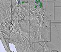 | 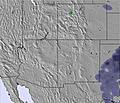 | 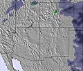 | 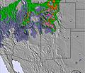 | 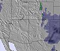 | 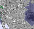 | ||||||||||||
— | — | — | — | — | — | — | — | — | — | — | — | — | — | — | — | — | — | |
mm | — | — | 1 | — | 4 | 5 | 1 | 3 | 1 | — | — | — | — | 5 | 2 | — | — | 1 |
max °C | 19 | 21 | 13 | 16 | 16 | 9 | 15 | 15 | 12 | 17 | 20 | 16 | 19 | 17 | 13 | 20 | 22 | 14 |
min °C | 16 | 19 | 11 | 14 | 10 | 8 | 11 | 13 | 11 | 14 | 20 | 13 | 16 | 12 | 12 | 16 | 21 | 13 |
chill °C | 16 | 19 | 11 | 14 | 10 | 7 | 10 | 13 | 11 | 14 | 20 | 13 | 16 | 12 | 11 | 16 | 21 | 12 |
Humid % | 37 | 22 | 55 | 48 | 49 | 96 | 73 | 50 | 60 | 49 | 24 | 45 | 39 | 42 | 54 | 39 | 23 | 59 |
Freeze m | 5700 | 5950 | 5550 | 5550 | 5750 | 5100 | 5350 | 5650 | 5400 | 5500 | 5900 | 5750 | 5700 | 5750 | 5450 | 5750 | 5950 | 5550 |
5:54 | — | — | 5:54 | — | — | 5:56 | — | — | 5:56 | — | — | 5:58 | — | — | 5:58 | — | — | |
— | 8:28 | — | — | 8:27 | — | — | 8:27 | — | — | 8:25 | — | — | 8:24 | — | — | 8:23 | — | |
Go pro and carve into:
Avalanche information: Colorado Avalanche Information Center
Latest snow reports near Vail:
| Top snow depth: | 0 cm |
|---|---|
| Bottom snow depth: | 0 cm |
| Fresh snowfall depth: | — |
| Last snowfall: | 21 May 2026 |
| Snow Alerts | Create Alert |
0.0 | Bluebird Powder days Fresh snow, mostly sunny, light wind. |
|---|---|
0.0 | Powder days Fresh snow, limited sun, any wind. |
0.0 | Bluebird days Average snow, mostly sunny, light wind. |


The above table gives the weather forecast for Vail at the specific elevation of 3498 m. Our sophisticated weather models allow us to provide snow forecasts for the top, middle and bottom ski stations of Vail. To access the weather forecasts for the other elevations, use the tab navigation above the table. For a wider view of the weather, check out the Weather Map of United States.
Click here to read further information on freezing levels and how we forecast our temperatures.
Overall 4.3 Based on 20 votes and 18 reviews
Of all the companies I have ever dealt with Vail Resorts is among the worst. They honestly do not care about their customers, all you are to them is a dollar figure and they will cycle to the next victim. The skiing might be great, but there are other resorts that actually care about their customers.
Todd Chamberlin from United States writes:
Of all the companies I have ever dealt with Vail Resorts is among the worst. They honestly do not care about their customers, all you are to them is a dollar figure and they will cycle to the next victim. The skiing might be great, but there are other resorts that actually care about their customers.


 Nearest