


Portillo Storm Snowfall Total Passes 5m / 17 Feet
A snow storm that has now continued for nine days has taken Chilean ski resort Portillo to a snowfall total of 5.2 metres (17 feet) so far, with more snow forecast.

Next 3 days weather summary:Moderate rain (total 11.0mm), heaviest on Wed afternoon. Warm (max 23°C on Fri afternoon, min 12°C on Wed night). Wind will be generally light. | Days 4-6 weather summary:Mostly dry. Warm (max 26°C on Sun afternoon, min 14°C on Sat night). Wind will be generally light. | ||||||||||||||||
Wed 29 | Thursday 30 | Friday 31 | Saturday 1 | Sunday 2 | Monday 3 | ||||||||||||
PM | night | AM | PM | night | AM | PM | night | AM | PM | night | AM | PM | night | AM | PM | night | |
rain shwrs | rain shwrs | some clouds | rain shwrs | clear | clear | cloudy | rain shwrs | clear | some clouds | clear | clear | some clouds | some clouds | clear | cloudy | some clouds | |
km/h | |||||||||||||||||
Snow map | 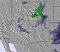 | 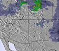 | 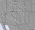 |  |  |  | |||||||||||
— | — | — | — | — | — | — | — | — | — | — | — | — | — | — | — | — | |
mm | 6 | 2 | — | 2 | — | — | — | 1 | — | — | — | — | — | — | — | — | — |
max °C | 16 | 14 | 18 | 20 | 17 | 21 | 23 | 18 | 21 | 23 | 19 | 22 | 26 | 22 | 24 | 26 | 19 |
min °C | 14 | 12 | 15 | 17 | 14 | 18 | 21 | 13 | 18 | 23 | 14 | 19 | 25 | 16 | 21 | 24 | 15 |
chill °C | 14 | 12 | 15 | 17 | 14 | 18 | 21 | 12 | 18 | 23 | 13 | 19 | 25 | 16 | 21 | 24 | 15 |
Humid % | 59 | 69 | 66 | 33 | 45 | 33 | 19 | 47 | 35 | 16 | 55 | 34 | 13 | 18 | 19 | 13 | 41 |
Freeze m | 5450 | 5250 | 5300 | 5550 | 5250 | 5350 | 5550 | 5050 | 5350 | 5700 | 5500 | 5650 | 5950 | 5600 | 5650 | 5750 | 5400 |
— | — | 6:01 | — | — | 6:03 | — | — | 6:03 | — | — | 6:05 | — | — | 6:05 | — | — | |
8:21 | — | — | 8:20 | — | — | 8:19 | — | — | 8:17 | — | — | 8:16 | — | — | 8:15 | — | |
Go pro and carve into:
Avalanche information: Colorado Avalanche Information Center
Latest snow reports near Vail:
| Top snow depth: | 0 cm |
|---|---|
| Bottom snow depth: | 0 cm |
| Fresh snowfall depth: | — |
| Last snowfall: | 21 May 2026 |
| Snow Alerts | Create Alert |
0.0 | Bluebird Powder days Fresh snow, mostly sunny, light wind. |
|---|---|
0.0 | Powder days Fresh snow, limited sun, any wind. |
0.0 | Bluebird days Average snow, mostly sunny, light wind. |


The above table gives the weather forecast for Vail at the specific elevation of 2986 m. Our sophisticated weather models allow us to provide snow forecasts for the top, middle and bottom ski stations of Vail. To access the weather forecasts for the other elevations, use the tab navigation above the table. For a wider view of the weather, check out the Weather Map of United States.
Click here to read further information on freezing levels and how we forecast our temperatures.
Overall 4.3 Based on 20 votes and 18 reviews
Worst scamming company I have ever seen. Haven't been able to ski due to weather and the lifts closed here at Falls creek. No refund just stupid snow credits only valid for 12mths. We are in Europe next year and was not planning on coming back. Disgraceful. Why on earth does anyone book early or want to come back?
Les from Australia writes:
Worst scamming company I have ever seen.
Haven't been able to ski due to weather and the lifts closed here at Falls creek.
No refund just stupid snow credits only valid for 12mths.
We are in Europe next year and was not planning on coming back. Disgraceful.
Why on earth does anyone book early or want to come back?


 Nearest