

America’s Next Indoor Snow Centre Takes Shape
Construction of a new indoor snow centre for skiers, boarders and tubers appears to be making good progress at Heritage Farm in Wayne County, West Virginia.

Next 4 days weather summary:Mostly dry. Very mild (max 13°C on Mon night, min 9°C on Tue night). Winds increasing (light winds from the N on Mon night, fresh winds from the W by Thu afternoon). | Days 5-7 weather summary:Heavy rain (total 20.0mm), heaviest during Sat morning. Very mild (max 10°C on Thu night, min 5°C on Sat night). Winds decreasing (strong winds from the W on Fri night, light winds from the NW by Sun morning). | |||||||||||||||
Tuesday 21 | Wednesday 22 | Thursday 23 | Friday 24 | Saturday 25 | ||||||||||||
night | AM | PM | night | AM | PM | night | AM | PM | night | AM | PM | night | AM | PM | night | |
clear | some clouds | some clouds | some clouds | some clouds | some clouds | cloudy | clear | clear | light rain | light rain | light rain | mod. rain | light rain | light rain | rain shwrs | |
km/h | ||||||||||||||||
Snow map | 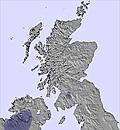 | 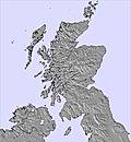 | 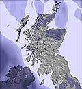 | 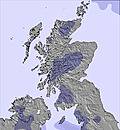 | 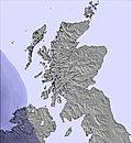 | 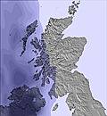 | ||||||||||
— | — | — | — | — | — | — | — | — | — | — | — | — | — | — | — | |
mm | — | — | — | — | — | — | — | — | — | 2 | 1 | 2 | 6 | 5 | 2 | 2 |
max °C | 13 | 13 | 13 | 10 | 11 | 11 | 10 | 11 | 11 | 10 | 10 | 8 | 7 | 8 | 8 | 7 |
min °C | 11 | 13 | 13 | 9 | 10 | 11 | 9 | 11 | 11 | 7 | 9 | 8 | 7 | 8 | 8 | 5 |
chill °C | 9 | 11 | 12 | 6 | 7 | 9 | 6 | 8 | 8 | 2 | 5 | 4 | 2 | 4 | 4 | 1 |
Humid % | 65 | 50 | 62 | 84 | 90 | 87 | 95 | 55 | 74 | 94 | 64 | 95 | 99 | 99 | 98 | 96 |
Freeze m | 3900 | 3800 | 3650 | 3300 | 3250 | 3250 | 3400 | 3600 | 3800 | 4000 | 3600 | 3000 | 3300 | 3100 | 3150 | 2850 |
— | 4:58 | — | — | 5:00 | — | — | 5:01 | — | — | 5:03 | — | — | 5:05 | — | — | |
— | — | 9:51 | — | — | 9:49 | — | — | 9:47 | — | — | 9:45 | — | — | 9:44 | — | |
Go pro and carve into:
Avalanche information: European Avalanche Warning Services (EAWS)
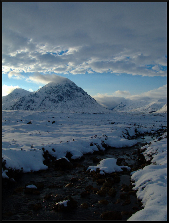
Latest snow reports near Glencoe Mountain Resort:
| Top snow depth: | 0 cm |
|---|---|
| Bottom snow depth: | 0 cm |
| Fresh snowfall depth: | — |
| Last snowfall: | 12 May 2026 |
| Snow Alerts | Create Alert |
0.0 | Bluebird Powder days Fresh snow, mostly sunny, light wind. |
|---|---|
0.0 | Powder days Fresh snow, limited sun, any wind. |
0.0 | Bluebird days Average snow, mostly sunny, light wind. |
The above table gives the weather forecast for Glencoe Mountain Resort at the specific elevation of 1108 m. Our sophisticated weather models allow us to provide snow forecasts for the top, middle and bottom ski stations of Glencoe Mountain Resort. To access the weather forecasts for the other elevations, use the tab navigation above the table. For a wider view of the weather, check out the Weather Map of United Kingdom.
Click here to read further information on freezing levels and how we forecast our temperatures.
Overall 3.3 Based on 31 votes and 27 reviews
To those expecting the newest lifts and thousands of meters of vertical you will be disappointed. However, if you pick your day you get some fantastic powder skiing, no queues, incredible views and friendly staff. Oh and it's just an hour and a half from Glasgow, and midweek is quite frankly a bargain at £20 for a student.
Jack from United Kingdom writes:
To those expecting the newest lifts and thousands of meters of vertical you will be disappointed. However, if you pick your day you get some fantastic powder skiing, no queues, incredible views and friendly staff.
Oh and it's just an hour and a half from Glasgow, and midweek is quite frankly a bargain at £20 for a student.
Read 26 more reviews of Glencoe Mountain Resort or submit your own


 Nearest