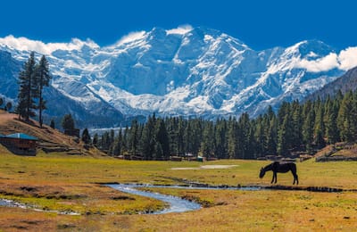
Whakapapa snow
Ski New Zealand

Whakapapa Snow Forecast

Weather Forecast for Whakapapa at 1962 m
Issued: 11 am  29 Apr 2024 (local time)

New snow in Whakapapa

3.9cm1.5in
Wed 1st (PM)
The snow forecast for Whakapapa is: Mild with light rain (total 4.0mm) on Wed afternoon Becoming colder with a light covering of snow, mostly falling on Wed night. Freeze-thaw conditions (max 5°C on Mon afternoon, min -4°C on Wed night). Winds increasing (calm on Mon night, strong winds from the NW by Wed afternoon).

Whakapapa Weather (Next 3 days): The snow forecast for Whakapapa is: Mild with light rain (total 4.0mm) on Wed afternoon Becoming colder with a light covering of snow, mostly falling on Wed night. Freeze-thaw conditions (max 5°C on Mon afternoon, min -4°C on Wed night). Winds increasing (calm on Mon night, strong winds from the NW by Wed afternoon).

Whakapapa Weather (Days 4-6): A dusting of new snow. Freeze-thaw conditions (max 4°C on Fri afternoon, min -2°C on Thu morning). Winds decreasing (strong winds from the WSW on Thu afternoon, calm by Fri afternoon).


Whakapapa Live Weather

ResortSnow DepthTemp. (°C)Wind (km/h)Weather
Top Lift: 0.0m
3
10
part cloud
Middle Lift: 
5
5
part cloud
Bottom Lift: 0.0m
7
0
part cloud
Powered by Snow-Forecast.comSnow-Forecast.com
6 Day Forecast
Issued: 11 am 29 Apr 2024 / Updates in ::
Change Forecast Height
Choose Forecast
Last 6 daysScroll left for last 6 daysNow
Monday
29
Tuesday
30
Wednesday
1
Thursday
2
Friday
3
Saturday
4
Sunday
5
AM
PM
night
AM
PM
night
AM
PM
night
AM
PM
night
AM
PM
night
AM
PM
night
AM
PM
night
clear
part cloud
part cloud
cloud
part cloud
clear
cloud
snow showers
mod snow
snow showers
light snow
light snow
cloud
clear
part cloud
part cloud
part cloud
part cloud
part cloud
part cloud
part cloud
clear
some clouds
some clouds
cloudy
some clouds
clear
cloudy
snow shwrs
mod. snow
snow shwrs
light snow
light snow
cloudy
clear
some clouds
some clouds
some clouds
some clouds
some clouds
some clouds
some clouds
 km/h
5
ENE
5
NE
5
N
5
S
10
SW
20
SW
20
W
25
WNW
35
W
30
WSW
40
WSW
35
WSW
20
SW
0
SW
15
N
20
WNW
20
W
0
SSE
15
NE
10
N
0
WNW
Snow map
 cm 
1.0
7
1.0
 mm 
4
max°C
4
5
3
4
4
3
2
2
-2
-1
-1
1
2
4
3
2
2
2
2
2
2
min°C
3
4
3
3
3
2
2
0
-4
-2
-1
-1
2
4
2
2
2
1
1
2
1
chill°C 
1
3
1
3
0
-3
-3
-8
-12
-9
-9
-8
-2
4
-3
-3
-2
-2
-3
-1
1
Humid% 
55
53
62
53
54
70
85
98
93
82
93
76
77
64
72
70
69
63
63
52
55
Freezing level (m
3000
3050
2750
2700
2800
2750
2500
2350
1300
1600
1750
2100
3050
3150
3250
2900
3000
2600
2400
2500
2500
topliftbotliftSea lvl1000m2000m3000m4000m5000m
3322211-1-5-3-3-123212111165365343-1011352331331
Sunrise
6:58
7:00
7:01
7:01
7:03
7:03
7:05
Sunset
5:30
5:29
5:28
5:25
5:24
5:23
5:22

Snow Radar

Latest snow reports near Whakapapa:

No recent snow reports

No recent snow reports

Whakapapa Snow Conditions

Top snow depth:0cm
Bottom snow depth:0cm
Fresh snowfall depth:
Last snowfall:29 Mar 2024
Snow AlertsCreate Alert
Other resorts in New Zealand are reporting: powder (0) / good piste (0)

Snow-Forecast Partner Offers

Snow History

Week 4 of April has on average:
0.0
Bluebird Powder days
Fresh snow, mostly sunny, light wind.
0.1
Powder days
Fresh snow, limited sun, any wind.
0.1
Bluebird days
Average snow, mostly sunny, light wind.