

Niseko Announce New Gondola
Niseko Village has confirmed a major lift expansion that will reshape access on the southern side of the Niseko United ski area, with a new gondola scheduled to open next winter and a second stage planned for 2027–28.

Next 3 days weather summary:Mostly dry. Freeze-thaw conditions (max 4°C on Thu morning, min -2°C on Wed night). Winds increasing (calm on Wed afternoon, fresh winds from the NNW by Sat morning). | Days 4-6 weather summary:Moderate rain (total 11.0mm), heaviest on Sat night giving way to a moderate fall of snow, heaviest on Sun night. Freeze-thaw conditions (max 3°C on Sun morning, min -2°C on Mon afternoon). Winds decreasing (strong winds from the NNE on Sun night, light winds from the NE by Mon night). | ||||||||||||||||
Wed 1 | Thursday 2 | Friday 3 | Saturday 4 | Sunday 5 | Monday 6 | ||||||||||||
PM | night | AM | PM | night | AM | PM | night | AM | PM | night | AM | PM | night | AM | PM | night | |
clear | clear | clear | clear | clear | clear | clear | clear | cloudy | cloudy | light snow | rain shwrs | some clouds | light snow | light snow | snow shwrs | some clouds | |
km/h | |||||||||||||||||
Snow map |  |  |  |  |  | 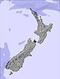 | |||||||||||
— | — | — | — | — | — | — | — | — | — | — | — | — | 5 | 3 | 2 | — | |
mm | — | — | — | — | — | — | — | — | — | — | 6 | 2 | — | 3 | — | — | — |
max °C | 3 | -1 | 4 | 3 | -1 | 4 | 3 | 0 | 1 | 1 | 2 | 3 | 3 | 2 | 0 | -1 | -1 |
min °C | -1 | -2 | 1 | -1 | -2 | 1 | 0 | -2 | 0 | 1 | 1 | 2 | 2 | 2 | 0 | -2 | -2 |
chill °C | -1 | -2 | 1 | -3 | -5 | -2 | -2 | -8 | -6 | -6 | -6 | -4 | -4 | -5 | -5 | -8 | -7 |
Humid % | 67 | 60 | 41 | 61 | 33 | 38 | 73 | 67 | 80 | 87 | 97 | 92 | 86 | 87 | 100 | 95 | 77 |
Freeze m | 2000 | 1950 | 2000 | 2100 | 2000 | 2100 | 2050 | 1900 | 1500 | 1850 | 2100 | 2000 | 2000 | 2000 | 1500 | 1350 | 1400 |
— | — | 7:37 | — | — | 7:37 | — | — | 7:37 | — | — | 7:37 | — | — | 7:37 | — | — | |
5:04 | — | — | 5:04 | — | — | 5:05 | — | — | 5:05 | — | — | 5:06 | — | — | 5:06 | — | |
Go pro and carve into:
Avalanche information: New Zealand Avalanche Advisory
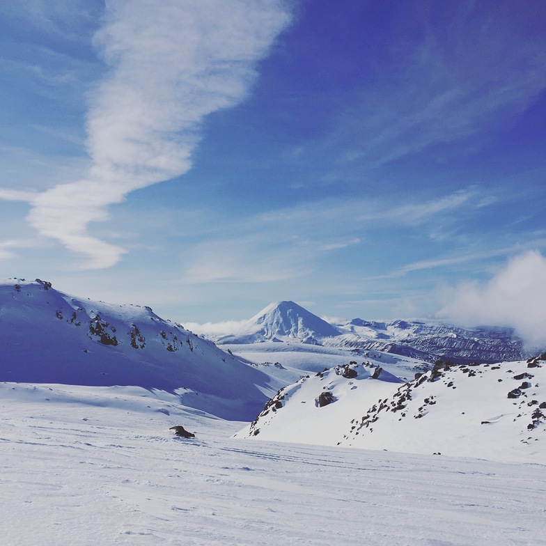
Latest snow reports near Tukino:
| Top snow depth: | — |
|---|---|
| Bottom snow depth: | — |
| Fresh snowfall depth: | — |
| Last snowfall: | 26 Jun 2026 |
| Snow Alerts | Create Alert |
0.2 | Bluebird Powder days Fresh snow, mostly sunny, light wind. |
|---|---|
1.1 | Powder days Fresh snow, limited sun, any wind. |
0.6 | Bluebird days Average snow, mostly sunny, light wind. |
The above table gives the weather forecast for Tukino at the specific elevation of 1489 m. Our sophisticated weather models allow us to provide snow forecasts for the top, middle and bottom ski stations of Tukino. To access the weather forecasts for the other elevations, use the tab navigation above the table. For a wider view of the weather, check out the Weather Map of New Zealand.
Click here to read further information on freezing levels and how we forecast our temperatures.
Overall 2.7 Based on 6 votes and 4 reviews
Such a shame because the mountain is good but run by racist staff. Would advise people to avoid.
Marcelo F from Uruguay writes:
Such a shame because the mountain is good but run by racist staff.
Would advise people to avoid.


 Nearest