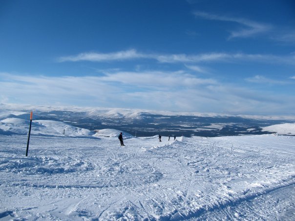


Portillo Storm Snowfall Total Passes 5m / 17 Feet
A snow storm that has now continued for nine days has taken Chilean ski resort Portillo to a snowfall total of 5.2 metres (17 feet) so far, with more snow forecast.

Next 3 days weather summary:Light rain (total 6.0mm), mostly falling on Thu afternoon. Mild temperatures (max 7°C on Sat afternoon, min 3°C on Thu night). Winds decreasing (near gales from the WSW on Thu morning, light winds from the WSW by Fri morning). | Days 4-6 weather summary:Light rain (total 8.0mm), mostly falling on Tue afternoon. Very mild (max 10°C on Sun afternoon, min 5°C on Sun morning). Wind will be generally light. | |||||||||||||||||
Thursday 30 | Friday 31 | Saturday 1 | Sunday 2 | Monday 3 | Tuesday 4 | |||||||||||||
AM | PM | night | AM | PM | night | AM | PM | night | AM | PM | night | AM | PM | night | AM | PM | night | |
some clouds | rain shwrs | clear | cloudy | rain shwrs | clear | rain shwrs | rain shwrs | some clouds | some clouds | some clouds | clear | clear | light rain | light rain | light rain | light rain | rain shwrs | |
km/h | ||||||||||||||||||
Snow map | 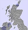 | 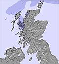 | 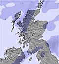 | 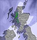 | 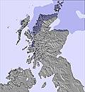 | 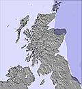 | ||||||||||||
— | — | — | — | — | — | — | — | — | — | — | — | — | — | — | — | — | — | |
mm | — | 2 | — | — | 2 | — | 1 | 1 | — | — | — | — | — | 1 | 2 | 1 | 3 | 1 |
max °C | 5 | 5 | 4 | 6 | 6 | 5 | 6 | 7 | 6 | 8 | 10 | 7 | 10 | 10 | 8 | 8 | 8 | 7 |
min °C | 5 | 5 | 3 | 4 | 6 | 4 | 5 | 6 | 4 | 5 | 9 | 7 | 8 | 8 | 7 | 7 | 8 | 6 |
chill °C | 0 | -1 | -1 | 1 | 2 | -1 | 0 | 2 | -1 | 2 | 8 | 6 | 8 | 6 | 6 | 6 | 7 | 5 |
Humid % | 81 | 94 | 79 | 89 | 84 | 84 | 88 | 82 | 83 | 84 | 62 | 75 | 58 | 75 | 96 | 88 | 94 | 89 |
Freeze m | 1800 | 1850 | 1750 | 1600 | 1950 | 1900 | 1850 | 2150 | 2050 | 2000 | 2400 | 2400 | 2400 | 2400 | 2350 | 2200 | 2400 | 2350 |
5:07 | — | — | 5:09 | — | — | 5:11 | — | — | 5:13 | — | — | 5:15 | — | — | 5:16 | — | — | |
— | 9:32 | — | — | 9:30 | — | — | 9:29 | — | — | 9:27 | — | — | 9:23 | — | — | 9:22 | — | |
Go pro and carve into:
Avalanche information: European Avalanche Warning Services (EAWS)
Latest snow reports near Cairngorm:
| Top snow depth: | 0 cm |
|---|---|
| Bottom snow depth: | 0 cm |
| Fresh snowfall depth: | — |
| Last snowfall: | 14 May 2026 |
| Snow Alerts | Create Alert |
0.0 | Bluebird Powder days Fresh snow, mostly sunny, light wind. |
|---|---|
0.0 | Powder days Fresh snow, limited sun, any wind. |
0.0 | Bluebird days Average snow, mostly sunny, light wind. |


The above table gives the weather forecast for Cairngorm at the specific elevation of 1097 m. Our sophisticated weather models allow us to provide snow forecasts for the top, middle and bottom ski stations of Cairngorm. To access the weather forecasts for the other elevations, use the tab navigation above the table. For a wider view of the weather, check out the Weather Map of United Kingdom.
Click here to read further information on freezing levels and how we forecast our temperatures.
Overall 3.2 Based on 43 votes and 87 reviews
The weather has largely been perfect all week. Blue sky and very little wind. Quite misty today, but still plenty of skiing to be done and most lofts and runs still open. The snow cannons are making a real difference this year. Like has been sad before; check the forecast, get up early (top car park will probably Be full by 10) or use the bus, use the restaurant outside peak times when the ski schools descend and have a fab time using the great snow sports on offer.
Jo from United Kingdom writes:
The weather has largely been perfect all week. Blue sky and very little wind. Quite misty today, but still plenty of skiing to be done and most lofts and runs still open. The snow cannons are making a real difference this year.
Like has been sad before; check the forecast, get up early (top car park will probably Be full by 10) or use the bus, use the restaurant outside peak times when the ski schools descend and have a fab time using the great snow sports on offer.


 Nearest