

Global Weekly Snow Roundup #314
Weekly Global Snow News, updated 14 May 2026: Fresh snowfall in Argentina, Australia and Lesotho signals winter’s approach, while Japan maintains the world’s deepest snowpack.

Next 3 days weather summary:A dusting of snow. Milder later with heavy rain (total 30.0mm) on Mon night. Freeze-thaw conditions (max 11°C on Mon afternoon, min 0°C on Sat morning). Wind will be generally light. | Days 4-6 weather summary:Heavy rain (total 24.0mm), heaviest during Thu afternoon. Very mild (max 10°C on Thu afternoon, min 3°C on Tue morning). Wind will be generally light. | |||||||||||||||||
Saturday 16 | Sunday 17 | Monday 18 | Tuesday 19 | Wednesday 20 | Thursday 21 | |||||||||||||
AM | PM | night | AM | PM | night | AM | PM | night | AM | PM | night | AM | PM | night | AM | PM | night | |
light snow | light snow | light snow | some clouds | cloudy | clear | clear | risk thun- der | heavy rain | light rain | some clouds | light rain | light rain | light rain | light rain | rain shwrs | rain shwrs | rain shwrs | |
km/h | ||||||||||||||||||
Snow map |  |  |  |  |  |  | ||||||||||||
3 | 1 | — | — | — | — | — | — | — | — | — | — | — | — | — | — | — | — | |
— | 2 | 2 | — | — | — | — | 1 | 25 | 2 | — | 3 | 3 | 1 | 4 | 4 | 6 | 1 | |
max °C | 0 | 3 | 2 | 4 | 8 | 7 | 9 | 11 | 8 | 4 | 9 | 9 | 7 | 8 | 9 | 8 | 10 | 10 |
min °C | 0 | 1 | 2 | 3 | 7 | 6 | 7 | 10 | 3 | 3 | 8 | 6 | 6 | 7 | 8 | 8 | 9 | 9 |
-4 | -3 | -2 | 2 | 7 | 5 | 7 | 10 | 1 | 1 | 8 | 4 | 5 | 4 | 6 | 6 | 7 | 8 | |
98 | 94 | 91 | 67 | 55 | 65 | 55 | 67 | 98 | 93 | 67 | 98 | 87 | 85 | 88 | 91 | 82 | 78 | |
1400 | 1700 | 1600 | 1950 | 2200 | 2350 | 2450 | 2600 | 2000 | 2100 | 2600 | 2350 | 2400 | 2650 | 2650 | 2700 | 2900 | 2950 | |
5:28 | — | — | 5:26 | — | — | 5:24 | — | — | 5:24 | — | — | 5:22 | — | — | 5:22 | — | — | |
— | — | 8:37 | — | — | 8:38 | — | — | 8:39 | — | — | 8:40 | — | — | 8:43 | — | — | 8:44 | |
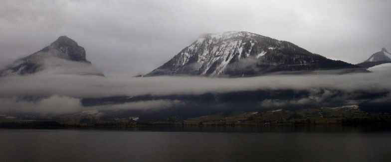
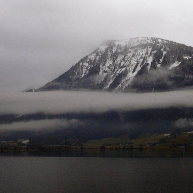
Latest snow reports near St Wolfgang:
| Top snow depth: | — |
|---|---|
| Bottom snow depth: | — |
| Fresh snowfall depth: | 1 cm |
| Last snowfall: | 15 May 2026 |
| Snow Alerts | Create Alert |
0.0 | Bluebird Powder days Fresh snow, mostly sunny, light wind. |
|---|---|
0.1 | Powder days Fresh snow, limited sun, any wind. |
0.0 | Bluebird days Average snow, mostly sunny, light wind. |
The above table gives the weather forecast for St Wolfgang at the specific elevation of 1350 m. Our sophisticated weather models allow us to provide snow forecasts for the top, middle and bottom ski stations of St Wolfgang. To access the weather forecasts for the other elevations, use the tab navigation above the table. For a wider view of the weather, check out the Weather Map of Austria.
Click here to read further information on freezing levels and how we forecast our temperatures.
Overall 3.5 Based on 1 vote and 7 reviews
St. Wolfgang can be reached in just under 1 hour from Salzburg Airport. We had early flight from Birmingham and were in the hotel Leifer by 1.30pm for lunch. Being picked up at 4.40pm on the following Saturday allowed for plenty of shopping in the resort and a walk up to one of the small waterfalls. The resort is very traditional and picturesque being located next to Wolfgangsee lake. Well worth getting a lake view. Slopes are a 30 mins (good weather) to 50 mins (it's snowing) bus ride away (you do get a seat) which is again very picturesque but becomes a bit tiresome by the end of the week. You can be picked up from outside of some hotels but can never be on the slopes until 10:15am (10:30am ski school start) and the bus(es) all leave at 4pm sharp! Ski school is the best we've ever had - I was in the intermediate group with "Killer" Fred and he was brilliant. The piste map looks tiny compared to most ski resorts being split into mainly blue runs on the one side (all T-bar lifts) and reds and one black on the other (4-seat chairlift). The reds are a good challenge and even the longer blue run from the top suddenly turns into a red near the bottom. Both sides have off limited off-piste, however, go with the right ski school instructor and they will take you through forest and away from the crowds to virgin snow that the crowds never visit. Overall, it is very small compared to the typical ski resort but you could always travel to Gossau near the Dachstien Glacier (1 hour on the ski bus though) for 130km of runs.
Nick White from United Kingdom writes:
St. Wolfgang can be reached in just under 1 hour from Salzburg Airport. We had early flight from Birmingham and were in the hotel Leifer by 1.30pm for lunch. Being picked up at 4.40pm on the following Saturday allowed for plenty of shopping in the resort and a walk up to one of the small waterfalls. The resort is very traditional and picturesque being located next to Wolfgangsee lake. Well worth getting a lake view.
Slopes are a 30 mins (good weather) to 50 mins (it's snowing) bus ride away (you do get a seat) which is again very picturesque but becomes a bit tiresome by the end of the week. You can be picked up from outside of some hotels but can never be on the slopes until 10:15am (10:30am ski school start) and the bus(es) all leave at 4pm sharp!
Ski school is the best we've ever had - I was in the intermediate group with "Killer" Fred and he was brilliant.
The piste map looks tiny compared to most ski resorts being split into mainly blue runs on the one side (all T-bar lifts) and reds and one black on the other (4-seat chairlift). The reds are a good challenge and even the longer blue run from the top suddenly turns into a red near the bottom. Both sides have off limited off-piste, however, go with the right ski school instructor and they will take you through forest and away from the crowds to virgin snow that the crowds never visit.
Overall, it is very small compared to the typical ski resort but you could always travel to Gossau near the Dachstien Glacier (1 hour on the ski bus though) for 130km of runs.


 Nearest