Europe Weekly Snow Roundup #289
Weekly Snow News for Europe, updated 19 November 2025: early-season openings expand as colder air returns and fresh snow improves glacier and high-altitude ski conditions.
- Early-season ski openings expand across the European Alps
- Austria eases back as Switzerland leads with most open ski areas
- French, Italian and Swiss resorts prepare more lifts after fresh snow
- Scandinavia enjoys deep early winter snow and improving conditions
- Snowmaking supports limited openings in Spain and Eastern Europe
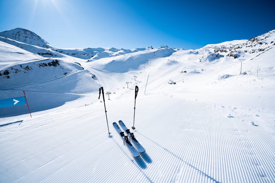
Europe’s season is starting to pick up pace, with the first ski areas set to open in the next few days that don’t rely on glaciers or on snow farmed from last spring to open some terrain – in other words, a combination of fresh natural snowfall and some base building from snow cannons. That said, the first ski areas due to start the French ski season this weekend, Tignes and Val Thorens, both have glacier slopes.
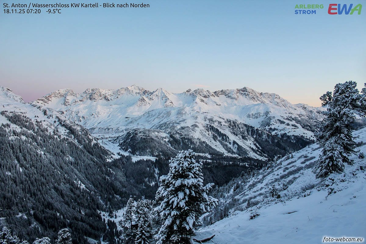
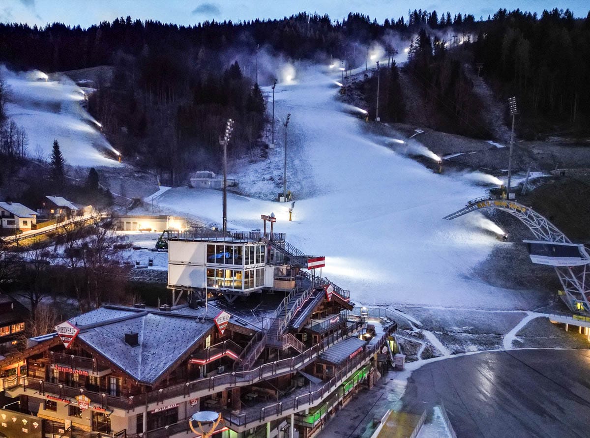
The good news is that after a milder, drier spell of weather in the first half of November than the seasonal average, following some good snowfalls in late October, it has now started snowing again on higher slopes in the Alps, with the snowline dropping. Temperatures are plummeting, so that’s good timing, although it remains to be seen how much can open on Friday or Saturday. Switzerland now has the most areas open in Europe, reaching 11 centres last weekend to overtake Austria, but that might change again this weekend with Obergurgl, Obertauern, Schladming, and Innsbruck’s Axamer Lizum ski areas all expected to open.
In Switzerland, Engelberg currently has 6 of 17 lifts running, with Andermatt operating 3 of 4 lifts and Les Diablerets 4 of 11, and upper slopes generally holding 15–30 cm of snow after recent falls.  Elsewhere in Europe, snowfall has been reported in many areas. The Pyrenees benefited from a major snowstorm last weekend, and a week of low temperatures and snowfall in Scotland has turned everything white there, too. Further north in Scandinavia, it has been snowing as well, with temperatures as low as -20 °C reported. There has also been fresh snowfall on mountains across Eastern Europe, with even Croatia’s slopes at Platak turning white.
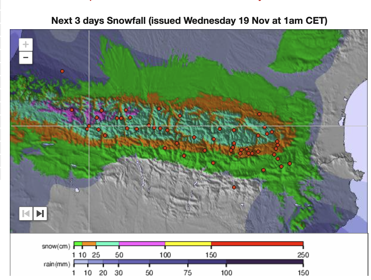
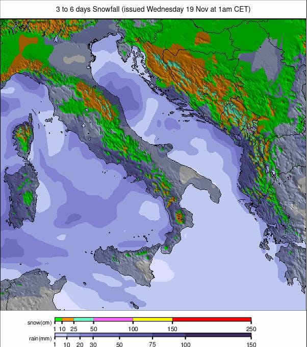
In Spain, all monitored ski resorts remain closed, with 0 cm of snow depth reported at all elevations, but a major snowfall is expected over the next three days, with forecasts of up to 50 cm in Astún and 46 cm in nearby Pyrenean areas such as Picos de Europa and Candanchú. Further afield in the northern hemisphere, all six monitored Japanese resorts remain closed for now, with no lifts running and a 0 cm base reported, despite recent snowfalls of roughly 30–80 cm across Gassan Glacier, Asahidake, and the Hakuba resorts. No openings are yet scheduled for the next eight weeks, although Gassan and Asahidake are expected to see further heavy snowfall over the next three days. 
🇦🇹 Austria Snow Report and Ski Conditions 2025/26
Austria is having one of the strongest early-season showings in Europe.
- Sölden — Classic early-season winner. Powder conditions, 10 cm fresh snow, with 60 % of lifts running and 0–24 cm on piste. Expect ~28 cm more over the next 3 days.
- Hintertux — Glacier reliability on show: 65 % open with solid upper-mountain depth (65 cm). 16 cm fresh and more on the way. Packed powder and groomed snow.
After several months of leading the world in the number of open ski areas, Austria has lost its top spot to Switzerland and the US, both now with double-digit numbers of open resorts. However, this coming weekend will see the first non-glacier ski areas opening in the country, all going well (excluding Kitzbühel, 0/65cm / 0/26”, which is currently opening on weekends thanks to snow-farmed snow recycled from last spring). Among the new openings are Obergurgl, which is also set to host the second round of World Cup slalom races after receiving the green light from the FIS earlier this month, as well as Obertauern, Schladming, and Innstraße ski area Axamer Lizum.
Of those already open, Sölden (0/25cm / 0/10”) continues to lead with a significant increase in open terrain thanks to both its Gaislachkogl and Giggijoch sectors opening. It is now the first in the world to have over 60 km (62 km / 39 miles) of slopes open this season, more than 40% of its total area. Hintertux (0/65cm / 0/32”) and the Stubai (10/45cm / 4/18”) also report more than 32 km (20 miles) of run available. The Kitzsteinhorn (0/70cm / 0/28”), Pitztal (10/75cm / 4/30”), Molltal (0/80cm / 0/32”), and Kaunertal (10/60cm / 4/24”) glaciers are all open.
We have yet to see typical winter conditions in November, with mostly dry and often mild weather. However, the freezing point has dropped below 1500 metres in recent days, and there has been light snowfall, with higher Austrian slopes reporting 0–15 cm (0-6”) of fresh snow in the past 48 hours. Snowpack levels are currently around 40% of normal for this time of year.
Austria Weather and Snow Forecast
Austrian ski areas are hopeful for a wintry change over the coming days, with fresh snow and colder temperatures favouring high-altitude resorts. A series of cold fronts will bring 10–30 cm (4-12 inches) of new snow to glacial and higher-altitude ski areas. Snowfall is expected to peak around 20–21 November, with freezing levels dropping below 1,500 m, enhancing snowmaking conditions nationwide. Winds will be moderate to strong at altitude, with temperatures ranging from -8°C to -2°C on upper slopes. Lower resorts may experience rain or sleet early on, but colder air should support snow cover by the weekend.
🇫🇷 France Snow Report and Ski Conditions 2025/26
A solid reset across the French Alps, with widespread fresh snowfall and more queued up.
- Courchevel — 7 cm recent snow, opening the day after tomorrow. More snowfall today and ~24 cm over the next 3 days.
- Méribel — Received 10 cm earlier this week. Fresh snow arrives today. Still closed, but the base is forming.
- Tignes — One of the stronger performers: 13 cm new, more today, and an additional 17 cm forecast. Opening in 2 days. Cold and snowy outlook.
- Val d’Isère — Similar pattern to Tignes: 14 cm new, more today, with 13 cm incoming. Opening in 2 days.
- Val Thorens — Deepest in France so far with 27–51 cm cover and 12 cm fresh. Opening the day after tomorrow. Another 13 cm due soon.
Anticipation is growing as the French ski season approaches, with Tignes and Val Thorens set to kick off this weekend. It’s not yet certain how much will be open. The French Alps received some healthy snowfall at the end of October, but mild temperatures early this month affected that. However, temperatures have dropped again in the past week, restoring good snowmaking conditions on higher terrain, and some fresh snowfall has arrived. So, fingers crossed. Current resort data show that all monitored French ski areas remain closed, but Val Thorens is already reporting 27 cm of snow at resort level and 51 cm on upper slopes after recent snowfalls, with a further 10–15 cm expected in the next few days. 
France Weather and Snow Forecast
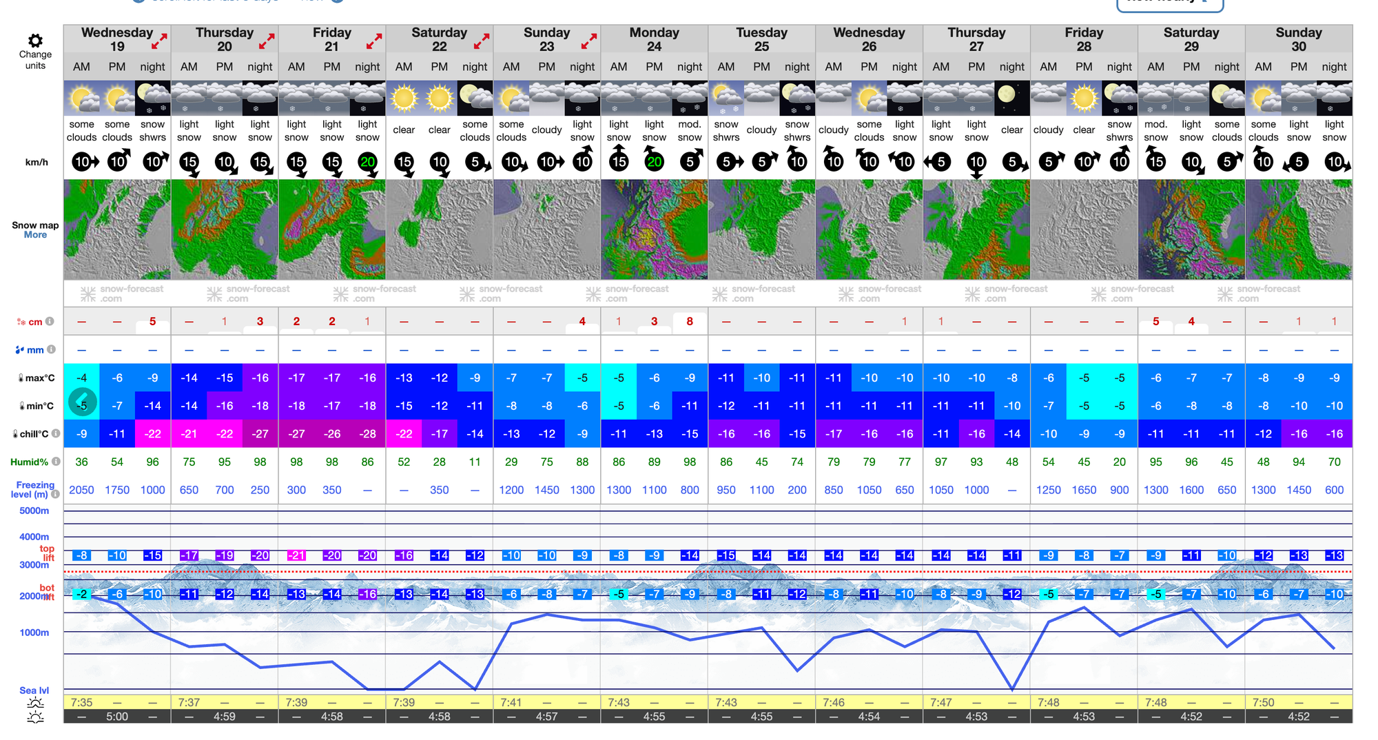
A new cold front will move through the French Alps midweek, bringing fresh snow to higher elevations and cooler temperatures across the region. From Wednesday, French ski areas could see 20–30cm (8-12”) of new snow, especially on upper slopes. Daytime highs will range around 5–10°C below 1500m, but will drop below freezing at higher altitudes, with overnight lows significantly colder.
Italy Snow Report and Ski Conditions 2025/26
Good early snowfalls, though most resorts remain closed for now.
- Courmayeur — 9 cm of recent snow, more due today. Closed, opening in 9 days. Additional 15 cm forecast.
- Sulden/Solda — Reliable showing: 20–40 cm base, 12 cm fresh, and 45 % open. More snow (24 cm) expected in the next few days.
- Cervinia — Strongest in Italy: 150 cm upper slope depth, 10 cm fresh, and 35 % open. More light snowfall today.
Italy has experienced similar warm weather to other parts of Western Europe until recently, and there has been no change in the three areas that have been open since last week. Cervinia (0/150cm / 0/60”) now shares 55km (35 miles) of slopes with its Swiss neighbour Zermatt, the second most in Europe and the world at present. You can also ski at Sulden (20/40cm / 6/16”) in the Ortler Alps or Val Senales (0/50cm / 0/20”), with Ponte di Legno/Passo Tonale opening next, this coming weekend. Temperatures have been falling, and snowfall has returned, resulting in much more wintry conditions over the past few days. Latest operational reports show Cervinia running 19 of 51 lifts with its 150 cm upper base, Sulden operating 5 of 11 lifts with around 40 cm at the top, and Val Senales also running 5 lifts with close to 50 cm at upper elevations.
Italy Weather and Snow Forecast
Italian ski resorts, especially in the Dolomites and western Alps, are expected to receive fresh snow and colder temperatures in the second half of this week, enhancing early-season prospects. Higher resorts such as Cervinia, Livigno, and Passo Tonale could experience 15–40 cm (6-16 inches) of snowfall, with peak accumulation likely around 20–21 November. Freezing levels will fall to 1,200–1,600 m, aiding snowmaking and natural coverage across mid-altitude terrain. Temperatures on upper slopes will range from -9°C to -3°C, with moderate winds and occasional cloud cover. Lower resorts may receive mixed precipitation early on, but colder air is forecast to favour snow by the weekend.
Switzerland Snow Report and Ski Conditions 2025/26
Fresh snow across much of the Alps, with several areas seeing double-digit totals and more on the way.
- Les Diablerets — Packed powder and groomed snow, with 15 cm recent snowfall and another top-up expected today. Around 35 % of the area is open, though cover remains thin at lower elevations (0–30 cm). Cold temperatures and a further 30 cm in the next 3 days keep things moving in the right direction.
- Mürren — A quieter start: 16 cm of new snow yesterday, and more falling today. Still not open (0 % lifts), with upper slopes carrying 24 cm. Expect improvement as this week’s snowfall accumulates.
- Verbier — Snowmaking dominates early season conditions, with 16 cm of natural snow earlier in the week. Currently 0 % open with light artificial cover (0–30 cm). Fresh snow arrives today — helpful, but still early days.
- Engelberg — One of Switzerland’s brightest spots. 28 cm new snow and more due tomorrow. 35 % open, with 1–30 cm on piste. Forecast shows another 31 cm over the next 3 days, staying cold.
- Andermatt — Powder reported, with 21 cm fresh snow and 75 % open — the strongest offering in the country right now. Cover is still modest (5–15 cm), but conditions are skiing well thanks to the colder temperatures.
- Davos — 15 cm fresh snowfall and a further 29 cm expected. Currently closed but opening tomorrow. Coverage remains thin for now (0–24 cm).
Switzerland has seen more ski areas open than anywhere else so far this winter, with Andermatt among the latest to open last weekend, bringing the total to 11; however, most are currently only opening on weekends. As with the rest of the Alps, early snow cover has been affected by mild weather in the first half of the month, but recently it has been colder with fresh snowfall and good snowmaking conditions. Saas Fee (100/175cm / 40/70”) has the deepest reported snow in Europe and 25 km (16 miles) of slopes are open.
Zermatt has extended its open terrain this week, more than doubling what is available to 55 km (35 miles), the second most in Europe at present, with skiing now possible across the border into Italy. Engelberg (5/30 cm / 2/12”) is also open daily, with the best conditions above 2,500 m altitude. Also open — though some only at weekends for now — are Adelboden (0/11cm / 0/4”), Andermatt (5/15cm / 2/6”), Arosa (0/10cm / 0/4”), Davos (0/20cm / 0/8”), Gstaad (Glacier 3000), Murren (0/20cm / 0/8”), St Moritz (Diavolezza glacier) (5/50cm / 2/20”), and Verbier (0/30cm / 0/12”). Recent reports highlight Engelberg as the most operational of the monitored Swiss resorts at present, with 6 lifts running and 30 cm of snow at the top, while Andermatt has 3 lifts open and Les Diablerets 4, all having seen fresh snow within the past 48 hours. 
Switzerland Weather and Snow Forecast
Swiss ski resorts are expected to receive fresh snow and colder air, with high-altitude areas likely to benefit most. Snowfall totals could reach 15–35 cm (6-14 inches) across glacial and elevated terrain, especially around 20–21 November. Freezing levels will drop to 1,200–1,600 m, supporting both snowmaking and natural accumulation. Upper slopes will experience temperatures between -10°C and -4°C, with moderate winds and variable cloud cover. Lower resorts may see rain or sleet early in the period, but colder air should turn conditions to snow by the weekend. Overall, it’s a promising period for Swiss glacier resorts, with improving piste conditions and scope for expanded terrain openings.
Scandinavia Snow Report and Ski Conditions 2025/26
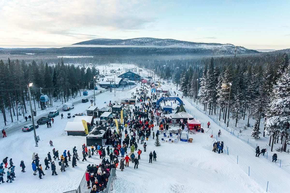
It has been a deep winter in Scandinavia over the past week, offering relief to skiers after mild spells in October and earlier this month. In Finland, Levi hosted the opening World Cup Slalom races of the 25-26 season at the weekend, and instead of the ribbons of white farmed snow on its slopes against an autumnal brown mountainside as seen until a week ago, the landscape looked very wintery and white with fresh snowfall and temperatures dropping to -18c. Currently, only a few centres remain open, each with just a few kilometres of terrain, mostly relying on snow farmed from last winter.
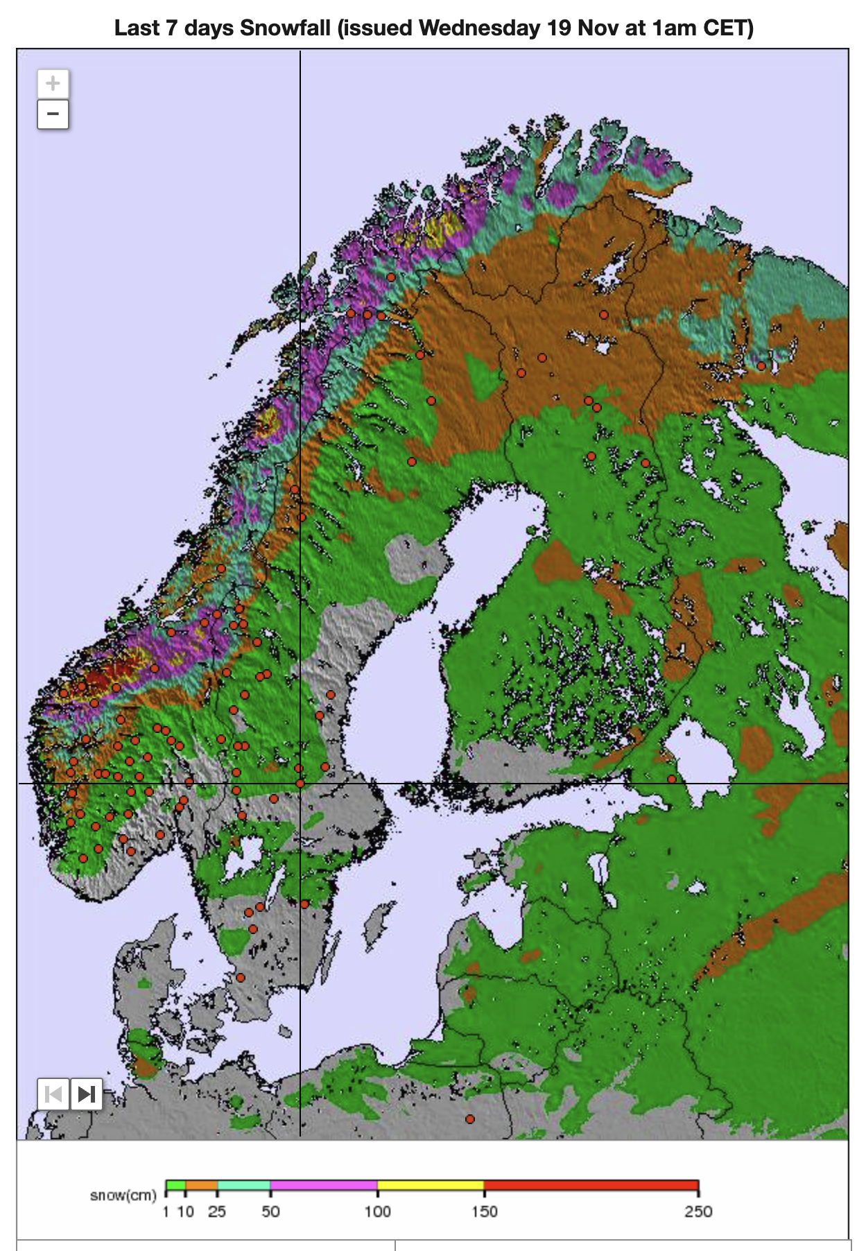
However, Sweden’s Tärnaby (30/50cm / 12/20”) opened at the weekend, becoming the second centre in the country to open, alongside Kåbdalis (20/60cm / 8/24”). There is no open ski area in Norway at the moment, as the Galdhopiggen glacier has ended its lengthy 2025 summer ski season. Still, centres including Geilo are expected to reopen this weekend for their 25-26 seasons. Also operational are Finland’s Levi (5/30cm / 2/12”) and Ruka (5/30cm / 2/12”), experiencing very low temperatures, approaching -20C, with natural snowfall now occurring.
Scandinavia Weather and Snow Forecast
Expect further fresh snowfall and colder temperatures across Scandinavia in the coming week, with ski slopes potentially receiving 10–25 cm (4-10 inches) of new snow by the weekend. Freezing levels will stay low, aiding both snowmaking and natural accumulation across most terrain. Upper-slope temperatures are forecast to range from -12°C to -6°C, with light to moderate winds and variable cloud cover. Early in the period, lower altitudes and more southerly resorts may experience mixed precipitation, but colder air should favour snow by the weekend.