Europe Weekly Snow Roundup #305
Weekly Snow News for Europe, updated 12 March 2026: Scandinavia leads snowfall again while spring sunshine dominates Alpine resorts and Saharan dust returns.
- Sunny spring skiing dominates the Alps
- Saharan dust clouds return to Alpine skies
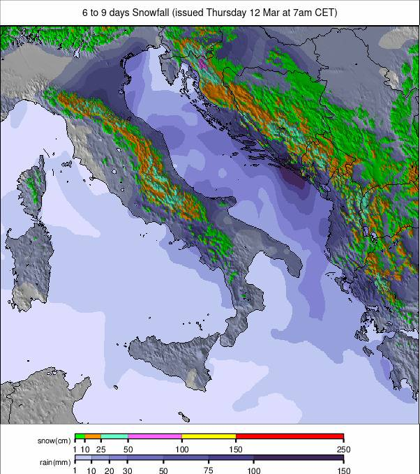
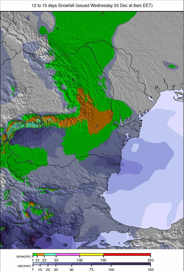
- Norway posts Europe’s biggest snowfalls again
- Southern Alps and Pyrenees see scattered snowfall
- Scottish ski centres receive fresh hill snow
Europe Intro
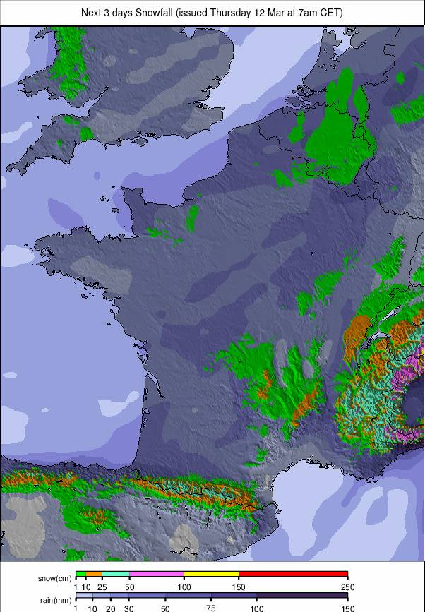
The Alps have now experienced a third consecutive week of predominantly sunny, springlike weather. Clear skies and mild temperatures have produced classic spring skiing conditions. Valley temperatures have climbed as high as +15°C in the afternoons, although higher slopes have remained closer to freezing. One change this week has been the arrival of weak weather fronts moving in from the southwest. These have brought occasional showers to the Pyrenees and the southern Alps, particularly in France.
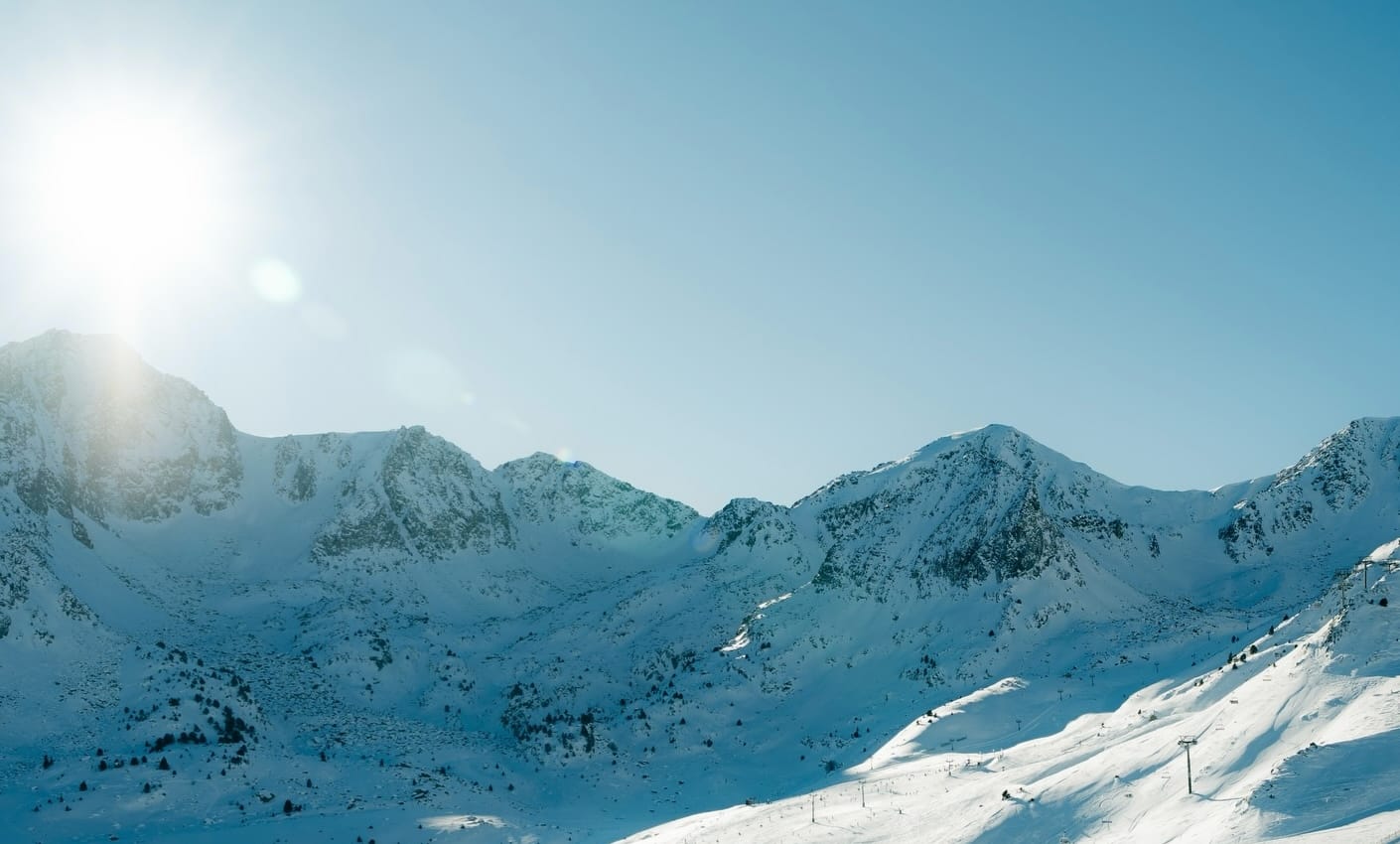
Meanwhile, Saharan dust has once again drifted north across parts of the Alps, producing hazy skies and leaving a light orange tint on some snow surfaces. Elsewhere, Scandinavia continues to deliver the most wintry weather in Europe. Temperatures remain largely below freezing across much of Norway, Sweden and Finland, particularly in northern and eastern areas. Snowfall has continued through the past week, with Norwegian resorts once again posting the largest totals in Europe — modest accumulations, but enough to refresh slopes.
Austria Snow Report
The Austrian Alps remain locked in a pattern of dry, sunny weather with increasingly spring-like conditions. Valley temperatures have been reaching 10–18°C, while mid-mountain elevations generally sit between –5°C and +5°C.
Glacier resorts including Stubai, Sölden and Kitzsteinhorn continue to hold the most reliable snow, maintaining sub-zero temperatures and occasional light snowfall. Lower resorts such as the Kitzbüheler Alpen, SkiWelt and Zillertal Arena are experiencing typical freeze–thaw cycles, with slopes softening through late morning. Overall snow cover remains strongest above 2,000m.
Austria Snow Forecast
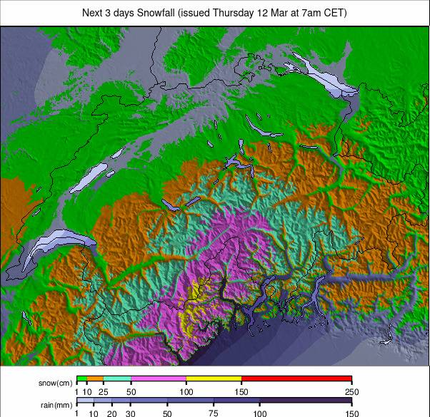
Light showers of rain, sleet and snow are expected mid-week across Austrian resorts, with freezing levels around 1,800–2,000m and summit temperatures between –4°C and –6°C. Snowfall totals are expected to be modest, generally just a dusting to a few centimetres before brighter skies return later in the day. Conditions should remain largely dry and mild through Thursday and Friday, with valley highs reaching 14–16°C.
France Snow Report
The French Alps also remain in spring mode, with mild valley temperatures but colder, firmer snow at altitude. Recent snowfall has returned to parts of the southern French Alps, although totals were generally only a few centimetres rather than the 20–50cm originally forecast. Isola 2000 recorded the largest total with around 25cm (10”).
High-altitude resorts including Tignes–Val d’Isère, Les 2 Alpes, Val Thorens and Alpe d’Huez continue to report deep cover despite some settling from the early-month peak of around 4m (160”).
Mid-mountain temperatures range between –5°C and +5°C, while lower slopes soften during the day due to freeze–thaw cycles. Above 2,000m the snowpack remains much more consistent, particularly on north-facing slopes and glacial terrain. Saharan dust has also been reported in parts of the French Alps, including St Gervais.
France Snow Forecast
Light snowfall is expected across the Southern Alps from mid-week, bringing modest fresh cover to resorts such as Serre Chevalier, Risoul and Isola 2000. More widespread snowfall may arrive by Saturday above roughly 1,600m, improving conditions for the weekend.
Italy Snow Report
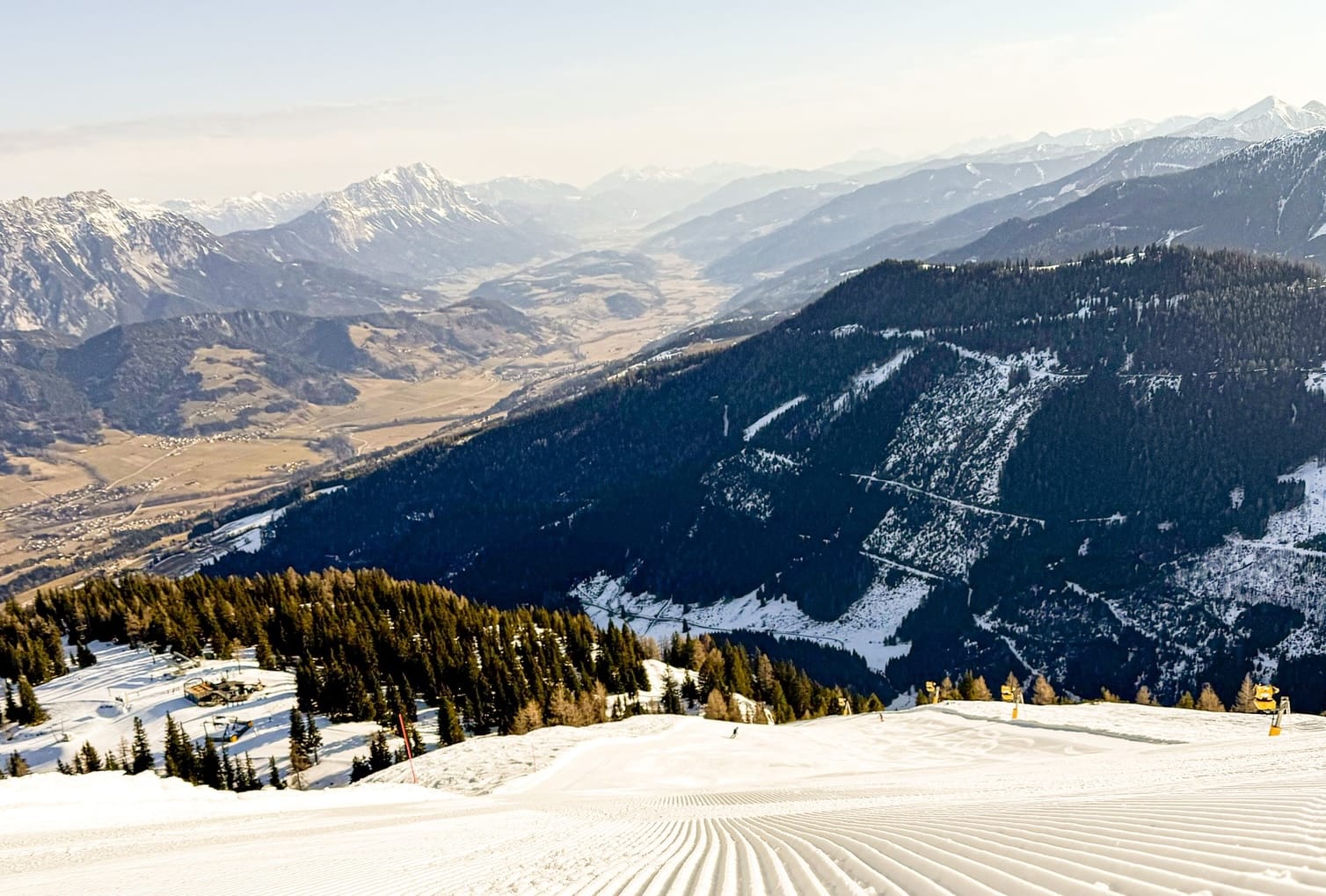
The Italian Alps and Dolomites are also experiencing mixed spring conditions, with mild temperatures in the valleys but colder, more reliable snow higher up. High-altitude resorts such as Cervinia and Livigno continue to offer the most dependable skiing above 2,000m, although lower slopes remain open despite increasingly variable conditions. As expected for mid-March, upper mountain terrain generally maintains firm, dry snow with regular sub-zero temperatures. Lower and mid-mountain pistes are experiencing regular freeze–thaw cycles, softening from late morning onwards.
Lower runs are becoming increasingly springlike with changing surface quality throughout the day. With about 85% of its terrain open, the vast Via Lattea area (60/360cm / 24/104”) — linking resorts including Sestriere and Sauze d’Oulx — currently offers the largest interconnected ski domain in the country. Nearby Mondolè Ski (160/270cm / 64/108”), which includes slopes above Artesina, Frabosa Soprana and Prato Nevoso, reports the deepest snowpack in Italy.
Italy Snow Forecast
Light snowfall is expected across parts of the higher Dolomites this week, with flurries possible in areas such as Val Gardena, Alta Badia, Arabba/Marmolada and Cortina. Elsewhere across the western Alps — including Cervinia, Monterosa and the Via Lattea — conditions are expected to remain largely dry, although cold enough at altitude to preserve the existing snowpack. Lombardy and Trentino show a similar pattern, with firm upper slopes but little meaningful new snowfall expected. Freezing levels are likely to remain around 2,000–2,400m.
Switzerland Snow Report
Across Switzerland, conditions continue to vary significantly depending on altitude. High alpine resorts with glacial terrain — including Zermatt, Saas-Fee, Engelberg and Andermatt — continue to provide some of the most reliable snow conditions. Upper-mountain depths here are widely reported between 150–230cm (5–8 feet), with temperatures remaining below freezing. At around 2,000m, many resorts report firm morning pistes that gradually soften into classic spring snow by the afternoon.
Lower slopes are showing signs of thinning cover after repeated freeze–thaw cycles, particularly on south-facing terrain. Overall, the strongest skiing continues to be found on higher north-facing terrain above 2,000m. Crans-Montana (140/192cm / 56/77”), another resort with glacial terrain, currently reports the deepest snowpack in Switzerland.
Switzerland Snow Forecast
Light snowfall is expected across parts of southern and eastern Switzerland from mid-week, bringing modest accumulations. Temperatures are forecast to drop slightly, helping maintain firmer piste conditions and improving overnight refreezing. Occasional flurries may continue through Thursday and Friday, mainly above mid-mountain elevations. A stronger system is expected to move through on Saturday, bringing more widespread snowfall across the central and southern Alps, particularly above 1,500–1,700m.
Pyrenees Snow Report
After largely sunny weather earlier in the forecast period, conditions across the Pyrenees have been more changeable than in the Alps. A mix of snow showers, cloud and occasional snowfall has moved through the region, depending largely on altitude. Major resorts including Baqueira Beret, Grandvalira, Formigal and Saint-Lary continue to report excellent upper-mountain depths, often between 200–350cm (7–12 feet). Conditions can change quickly as passing fronts bring sleet, snow showers and shifting visibility. As elsewhere in southern Europe, skiing is best at altitude, although most resorts in the region still report almost all slopes open.
Pyrenees Snow Forecast
After the recent unsettled spell, the Pyrenees are expected to return to a brighter and drier pattern. Sunshine should dominate across Andorra, France and Spain, with light winds and freezing levels climbing well above 2,000m. Mid-mountain temperatures are forecast to remain comfortably above freezing during the afternoon, although clear nights will allow the snowpack to refreeze. Resorts including Grandvalira, Baqueira Beret, Saint-Lary and Formigal should see stable spring conditions through the weekend. Early next week, forecast models suggest a shift toward cooler and more unsettled weather that could bring fresh snowfall, particularly at higher elevations.
Scandinavia Snow Report
Scandinavia continues to offer the most wintry conditions in Europe as meteorological spring begins. Across Norway, Sweden and Finland, temperatures remain largely below freezing, particularly across northern and eastern regions.
Snow still covers trees and landscapes in many areas. Fresh snowfall has been reported during the past week, with Norwegian resorts once again topping Europe’s snowfall charts. The totals have not been especially large, but they have provided a welcome refresh to slopes. Coastal resort Voss (105/110cm / 42/44”) reported around 13cm (5”) at the end of last week, the largest snowfall recorded in Europe during that period, although the snow was described locally as “wet”.
Clear skies have also produced very cold nights in parts of the region, with temperatures dropping to –10°C or even –15°C in northern and eastern areas. Further south, daytime highs are typically around –5°C.
Scandinavia Snow Forecast
A strong Atlantic flow is expected to push repeated snowfall systems into western Norway from mid-week. Coastal resorts such as Voss and Myrkdalen could see significant accumulations as moist air hits the fjord-side mountains. Snow levels should remain low thanks to the colder air mass. Further inland and across Sweden, snowfall is expected to be lighter and more intermittent, with clearer spells around major resorts such as Åre and Sälen. Another vigorous system is likely to arrive over the weekend, bringing renewed heavy snowfall to western Norway and lighter flurries across central Sweden.
Eastern Europe Snow Report
Eastern Europe is currently experiencing classic spring conditions, with temperatures fluctuating between roughly –10°C and +10°C through the daily cycle. The freezing level generally sits between 1,000m and 1,500m.
Bulgarian ski resorts have enjoyed almost continuous sunshine during the day, although Bansko (10/190cm / 4/76”) has seen snow cover at resort level roughly halve over the past week. Despite this, the resort still reports top-to-bottom skiing. In Slovakia, Jasná (40/90cm / 16/36”) currently reports around 90% of its terrain open, the most extensive coverage in the region.
Eastern Europe Snow Forecast
Conditions across the region are expected to turn slightly cooler later this week, although largely dry weather should continue. Bansko is forecast to remain springlike with daytime highs around 9–10°C and little significant new snowfall expected. Higher slopes may still see occasional flurries. Jasná is expected to remain colder, with upper-mountain temperatures between –6°C and 0°C and stable snow conditions maintained through artificial snowmaking. Overall, most ski areas across the region remain fully operational.
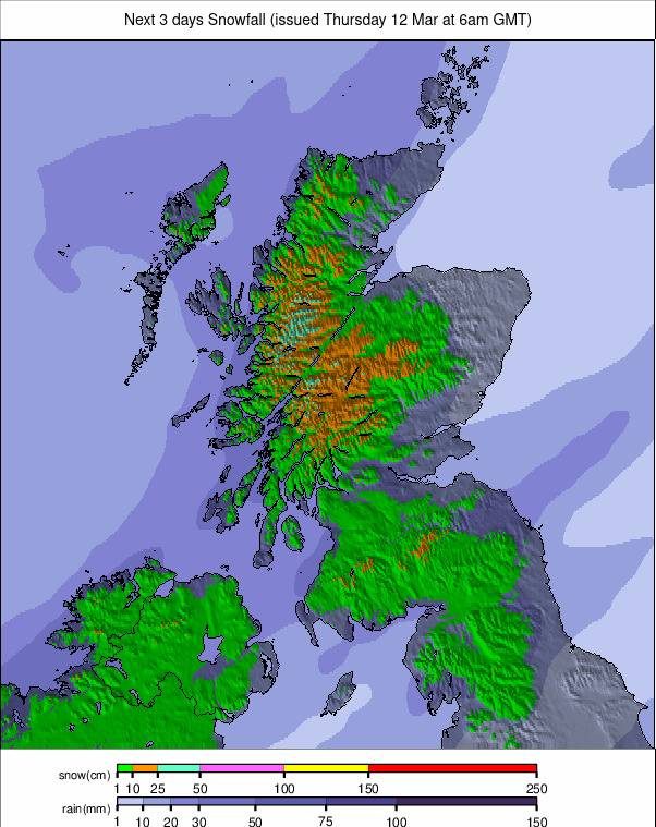
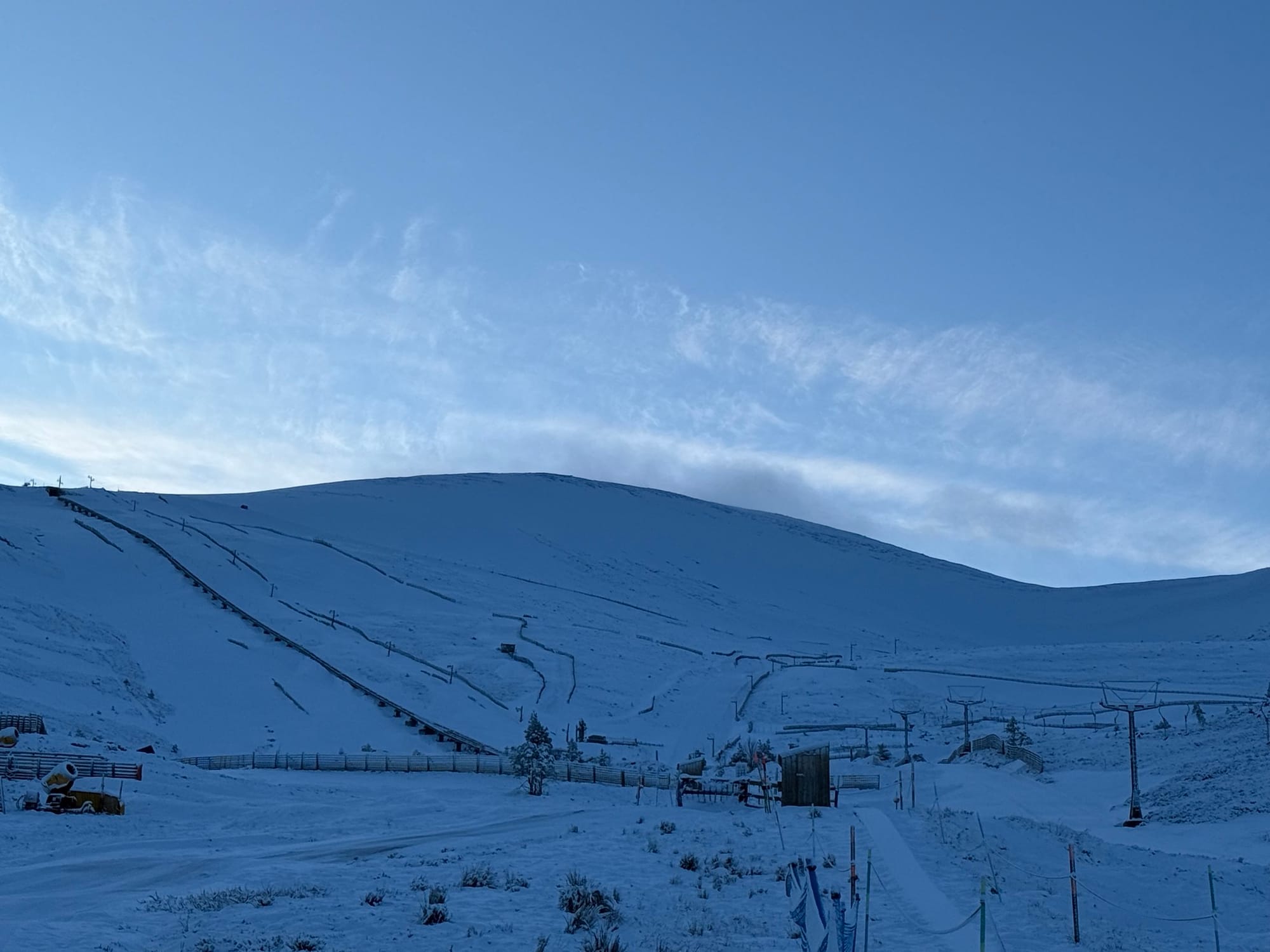
Scotland Snow Report
Scotland’s ski centres have experienced mixed conditions with milder afternoons but periodic showers bringing fresh snowfall to higher terrain. Nevis Range remains closed for snowsports, while The Lecht currently has only limited terrain open and was closed earlier this week. Cairngorm, Glencoe and Glenshee continue to offer natural snow terrain beyond that supported by snowmaking, particularly on higher runs.
Glencoe advises that most currently open terrain is best suited to confident intermediate and advanced skiers, although its all-weather nursery slope remains available at the base.
Scotland Snow Forecast
Unsettled Atlantic weather is expected to continue across the Scottish Highlands. Resorts including Cairngorm, Glencoe and Nevis Range may see periods of rain, sleet and hill snow through the remainder of the week.
Colder air should allow more consistent snowfall on higher slopes, although strong winds could occasionally disrupt uplift operations. Further pulses of wintry weather are possible into the weekend, potentially improving cover on higher terrain where temperatures remain low enough.