
Ski Lessons by SkiBro
BOOK NOW
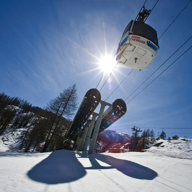
Ski lessons in Serre Chevalier
Book now

Serre Chevalier Weather (Next 3 days): The snow forecast for Serre Chevalier is: Heavy rain (total 45.0mm), heaviest during Mon afternoon. Later becoming colder with a dusting of snow on Mon night. Mild temperatures (max 7°C on Sun afternoon, min 1°C on Sat morning). Wind will be generally light.
Serre Chevalier Weather (Days 4-6): Light rain (total 7.0mm) at first, then becoming colder with a dusting of snow on Tue night. Freeze-thaw conditions (max 8°C on Thu afternoon, min -1°C on Tue night). Wind will be generally light.
| Resort | Snow Depth | Temp. (°C) | Wind (km/h) | Weather | ||
|---|---|---|---|---|---|---|
| Top Lift: | 0.0 m | -3 | ||||
| Middle Lift: | 3 | |||||
| Bottom Lift: | 0.0 m | 9 |
Latest snow reports near Serre Chevalier:
Great snow conditions throughout area. Cloudy this morning, clearing later. from Val Thorens

Saturday 4 | Sunday 5 | Monday 6 | Tuesday 7 | Wednesday 8 | Thursday 9 | Friday 10 | |||||||||||||||
AM | PM | night | AM | PM | night | AM | PM | night | AM | PM | night | AM | PM | night | AM | PM | night | AM | PM | night | |
cloudy | light rain | light rain | light rain | light rain | light rain | mod. rain | heavy rain | light snow | light snow | light snow | light snow | some clouds | rain shwrs | rain shwrs | some clouds | risk thun- der | rain shwrs | clear | rain shwrs | rain shwrs | |
km/h | |||||||||||||||||||||
Snow map |  |  |  |  |  |  |  | ||||||||||||||
— | — | — | — | — | — | — | — | 2.0 | — | 1.0 | 3 | — | — | — | — | — | — | — | — | — | |
— | 1.0 | 4 | 2.0 | 2.0 | 4 | 10 | 13 | 9 | — | 2.0 | — | — | 2.0 | 1.0 | — | 1.0 | 1.0 | — | 1.0 | 1.0 | |
max°C | 3 | 4 | 4 | 4 | 7 | 6 | 3 | 3 | 3 | 2 | 2 | 1 | 3 | 5 | 4 | 6 | 8 | 7 | 7 | 10 | 8 |
min°C | 1 | 4 | 3 | 4 | 7 | 4 | 3 | 3 | 1 | 1 | 2 | -1 | 1 | 4 | 2 | 4 | 8 | 4 | 5 | 9 | 5 |
0 | 3 | 1 | 3 | 6 | 2 | 1 | 1 | 0 | 0 | 0 | -4 | -1 | 3 | 1 | 4 | 8 | 4 | 5 | 8 | 4 | |
71 | 92 | 99 | 97 | 82 | 91 | 99 | 99 | 99 | 95 | 95 | 96 | 85 | 82 | 82 | 73 | 75 | 91 | 72 | 71 | 74 | |
2400 | 2600 | 2600 | 2700 | 3000 | 2800 | 2650 | 2600 | 2350 | 2250 | 2250 | 2050 | 2500 | 2700 | 2600 | 2950 | 3100 | 2900 | 2900 | 3150 | 3150 | |
6:18 | — | — | 6:16 | — | — | 6:15 | — | — | 6:13 | — | — | 6:13 | — | — | 6:11 | — | — | 6:09 | — | — | |
— | — | 8:43 | — | — | 8:44 | — | — | 8:45 | — | — | 8:46 | — | — | 8:47 | — | — | 8:49 | — | — | 8:50 | |
Heavy rain (total 45.0mm), heaviest during Mon afternoon. Later becoming colder with a dusting of snow on Mon night. Mild temperatures (max 7°C on Sun afternoon, min 1°C on Sat morning). Wind will be generally light.
Light rain (total 7.0mm) at first, then becoming colder with a dusting of snow on Tue night. Freeze-thaw conditions (max 8°C on Thu afternoon, min -1°C on Tue night). Wind will be generally light.
Latest snow reports near Serre Chevalier:
Great snow conditions throughout area. Cloudy this morning, clearing later. from Val Thorens
| Top snow depth: | 0 cm |
|---|---|
| Bottom snow depth: | 0 cm |
| Fresh snowfall depth: | 19 cm |
| Last snowfall: | 2 May 2024 |
| Snow Alerts | Create Alert |
0.1 | Bluebird Powder days Fresh snow, mostly sunny, light wind. |
|---|---|
0.1 | Powder days Fresh snow, limited sun, any wind. |
0.0 | Bluebird days Average snow, mostly sunny, light wind. |
The above table gives the weather forecast for Serre Chevalier at the specific elevation of 2000 m. Our sophisticated weather models allow us to provide snow forecasts for the top, middle and bottom ski stations of Serre Chevalier. To access the weather forecasts for the other elevations, use the tab navigation above the table. For a wider view of the weather, check out the Weather Map of France.
Click here to read further information on freezing levels and how we forecast our temperatures.
Overall 4.4 Based on 45 votes and 57 reviews
Probably my favourite ski resort! I spent a good few weeks here in 2022 on a season pass, it is one of the biggest resorts in France for piste length, I didn't go off piste but I was told they have good options for that too. Getting here is perfectly easy, although not necessarily from Geneva. I like the night train from Paris to Briancon, which is the main town and genuinely in Serre Chevalier, there is also a regular bus from Grenoble and connections from Turin by either bus or train. The variety of pistes is great and the area itself is quite compact. Possibly there could ideally be a few more black runs but a few of their reds could easily be upgraded in all honesty. Pylons is the best black and petit Alpe and Echaillon are challenging reds. You can basically go everywhere on chairlifts - the way up from Briancon is the only exception - so no need to take off your skis and the time spent going up to going down is much better than other resorts I have been to (eg Alpe d'Huez). Despite the size of the resort even relatively basic intermediate skiers have a lot of options. The whole resort can be traversed "left to right" on blue slopes, coming back there is the bus, or one long but relatively easy red (Cucumelle) is the only difficulty. Decent and better skiers can also enjoy some fun blue runs, the half-pipe-esqe Tetras stands out as well as Pas de l'Ane (take the first left). One of the defining features at Serre Che for me is that the pistes have character - these are not typically just roads of varying steepness on the side of a mountain - it feels like each piste, or most at least - are different with their own difficulties and characteristics. Some are bumpy, some narrow and undulating, some fill with powder and others, simply fun! Logistics deserve a mention. Serre Che is set out along one valley with a bus running end to end. This means if you end up in the wrong place at the end of the day the max cost is two euros, not a two hour taxi from another valley (or country - PdS!) The bus runs through the day, including to the train station, so is genuinely useful for bringing you to your accommodation and taking you home on the last day. The best places to stay probably are any of the villages except Monetier or Briancon - while both are very nice your chances to ski back directly rather than taking the afternoon bus are much greater here. Briancon also has trouble with wind - if the way up is closed the bus to other villages is thankfully free - but we all prefer skis to wheels so still not ideal. A few negatives. The wind in Briancon. Famous for sun, being on the southern side of the Alps means potentially less snow. When I was there unluckily it snowed very little, although many places in France had this experience, it is less snow sure than other resorts. However, snow making was good and the skiing was still great fun, we mostly lacked off piste. The bus is not really designed for skiers, Briancon is a real town in the Alps - in the morning you may squeeze your skis next to a real person going to work. The transport from Turin was a bit dysfunctional, although this is not really a fault of the resort it does complicate things. If you don't speak French and use public transport and ignore a warning that the bus is cancelled then that is on you, sorry! Quite a few pistes didn't open much or at all in 2022 - none of the blues down into Briancon were ever open that I saw, neither the black into Monetier. Finally, the eco credentials are worth mentioning. Serre Che seems to have gone in on renewables more than most resorts. Quite a few chairlifts are covered in solar panels which are alleged to produce more than they consume. The water pipes for snowmaking have been repurposed for hydro electric storage and generation, and there are two wind turbines as well. Only two seems like a gimmick - it seems that every ski resort should have more considering their elevation, but it is a start I suppose. And finally, for the eco conscious, by far the largest part of our carbon footprint when skiing is flying to the resort - and Serre Che has a direct overnight train from Paris to Briancon - and train + bus options from Paris via Grenoble or Modane, so if you really want to help make skiing greener, give the train a chance!
David Smith from United Kingdom writes:
Probably my favourite ski resort! I spent a good few weeks here in 2022 on a season pass, it is one of the biggest resorts in France for piste length, I didn't go off piste but I was told they have good options for that too.
Getting here is perfectly easy, although not necessarily from Geneva. I like the night train from Paris to Briancon, which is the main town and genuinely in Serre Chevalier, there is also a regular bus from Grenoble and connections from Turin by either bus or train.
The variety of pistes is great and the area itself is quite compact. Possibly there could ideally be a few more black runs but a few of their reds could easily be upgraded in all honesty. Pylons is the best black and petit Alpe and Echaillon are challenging reds. You can basically go everywhere on chairlifts - the way up from Briancon is the only exception - so no need to take off your skis and the time spent going up to going down is much better than other resorts I have been to (eg Alpe d'Huez).
Despite the size of the resort even relatively basic intermediate skiers have a lot of options. The whole resort can be traversed "left to right" on blue slopes, coming back there is the bus, or one long but relatively easy red (Cucumelle) is the only difficulty. Decent and better skiers can also enjoy some fun blue runs, the half-pipe-esqe Tetras stands out as well as Pas de l'Ane (take the first left). One of the defining features at Serre Che for me is that the pistes have character - these are not typically just roads of varying steepness on the side of a mountain - it feels like each piste, or most at least - are different with their own difficulties and characteristics. Some are bumpy, some narrow and undulating, some fill with powder and others, simply fun!
Logistics deserve a mention. Serre Che is set out along one valley with a bus running end to end. This means if you end up in the wrong place at the end of the day the max cost is two euros, not a two hour taxi from another valley (or country - PdS!) The bus runs through the day, including to the train station, so is genuinely useful for bringing you to your accommodation and taking you home on the last day. The best places to stay probably are any of the villages except Monetier or Briancon - while both are very nice your chances to ski back directly rather than taking the afternoon bus are much greater here. Briancon also has trouble with wind - if the way up is closed the bus to other villages is thankfully free - but we all prefer skis to wheels so still not ideal.
A few negatives. The wind in Briancon. Famous for sun, being on the southern side of the Alps means potentially less snow. When I was there unluckily it snowed very little, although many places in France had this experience, it is less snow sure than other resorts. However, snow making was good and the skiing was still great fun, we mostly lacked off piste. The bus is not really designed for skiers, Briancon is a real town in the Alps - in the morning you may squeeze your skis next to a real person going to work. The transport from Turin was a bit dysfunctional, although this is not really a fault of the resort it does complicate things. If you don't speak French and use public transport and ignore a warning that the bus is cancelled then that is on you, sorry! Quite a few pistes didn't open much or at all in 2022 - none of the blues down into Briancon were ever open that I saw, neither the black into Monetier.
Finally, the eco credentials are worth mentioning. Serre Che seems to have gone in on renewables more than most resorts. Quite a few chairlifts are covered in solar panels which are alleged to produce more than they consume. The water pipes for snowmaking have been repurposed for hydro electric storage and generation, and there are two wind turbines as well. Only two seems like a gimmick - it seems that every ski resort should have more considering their elevation, but it is a start I suppose. And finally, for the eco conscious, by far the largest part of our carbon footprint when skiing is flying to the resort - and Serre Che has a direct overnight train from Paris to Briancon - and train + bus options from Paris via Grenoble or Modane, so if you really want to help make skiing greener, give the train a chance!
The Serre Chevalier skiing weather widget is available to embed on external websites free of charge. It provides a daily summary of our Serre Chevalier snow forecast and current weather conditions. Simply go to the feed configuration page and follow the 3 simple steps to grab the custom html code snippet and paste it into your own site. You can choose the snow forecast elevation (summit, mid-mountain or bottom lift) and metric/imperial units for the snow forecast feed to suit your own website…. Click here to get the code.
View detailed snow forecast for Serre Chevalier at:
snow-forecast.com


 Nearest