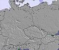
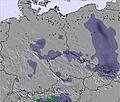
The above table gives the weather forecast for Winterberg at the specific elevation of 640 m. Our sophisticated weather models allow us to provide snow forecasts for the top, middle and bottom ski stations of Winterberg. To access the weather forecasts for the other elevations, use the tab navigation above the table. For a wider view of the weather, check out the Weather Map of Germany.
Click here to read further information on freezing levels and how we forecast our temperatures.
Winterberg is a completely different experience to anything that I have ever been to before. I have been skiing for 6 years and that has been at big alpine resorts (Garmisch-Partenkirchen) and Winterberg is a big down scale from that. I don't think it's quite as bad as some make it out to be but it is very small and it is a good place for beginners to learn and better than that if you live in the far south east of England it is closer to go to Winterberg rather than Scotland (so you can drive with help of a train or ferry). The trip on the other side is less than 5 hours. The only other thing is I recommend you don't drive through Essen as it's a log jam and go during the week (school holiday? so you can teach the kids) as during the weekend it's full of people from the Netherlands. Knowing a few words of German is a must as many don't speak any English. Finally, it's cheaper than any resort that I have seen of this size (Scotland) so it's good to learn because why pay for a big ski area pass if you're only going to use a few learner slopes. Whereas, in Winterberg, an adult day pass is 23 euros.
Winterberg is a completely different experience to anything that I have ever been to before. I have been skiing for 6 years and that has been at big alpine resorts (Garmisch-Partenkirchen) and Winterberg is a big down scale from that. I don't think it's quite as bad as some make it out to be but it is very small and it is a good place for beginners to learn and better than that if you live in the far south east of England it is closer to go to Winterberg rather than Scotland (so you can drive with help of a train or ferry). The trip on the other side is less than 5 hours. The only other thing is I recommend you don't drive through Essen as it's a log jam and go during the week (school holiday? so you can teach the kids) as during the weekend it's full of people from the Netherlands. Knowing a few words of German is a must as many don't speak any English. Finally, it's cheaper than any resort that I have seen of this size (Scotland) so it's good to learn because why pay for a big ski area pass if you're only going to use a few learner slopes. Whereas, in Winterberg, an adult day pass is 23 euros.
Free Snow-Forecast.com weather widget for your website
Embed the Winterberg weather widget on your site for free. It provides a weekly snapshot of snow and rain conditions across all elevations. Follow the two quick steps to grab your custom code and paste it into your site. Choose between metric or imperial units. Click here to get the code.


 Nearest