

America’s Next Indoor Snow Centre Takes Shape
Construction of a new indoor snow centre for skiers, boarders and tubers appears to be making good progress at Heritage Farm in Wayne County, West Virginia.

Next 3 days weather summary:Light rain (total 6.0mm) at first, then becoming colder with a dusting of snow on Thu afternoon. Freeze-thaw conditions (max 7°C on Tue afternoon, min -3°C on Thu night). Wind will be generally light. | Days 4-6 weather summary:Mostly dry. Freeze-thaw conditions (max 7°C on Mon morning, min -2°C on Fri afternoon). Wind will be generally light. | ||||||||||||||||
Tue 21 | Wednesday 22 | Thursday 23 | Friday 24 | Saturday 25 | Sunday 26 | ||||||||||||
PM | night | AM | PM | night | AM | PM | night | AM | PM | night | AM | PM | night | AM | PM | night | |
some clouds | some clouds | light rain | light rain | light snow | light snow | light snow | light snow | some clouds | some clouds | cloudy | light snow | light snow | some clouds | clear | clear | clear | |
km/h | |||||||||||||||||
Snow map | 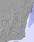 | 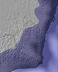 | 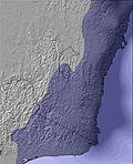 | 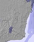 | 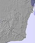 | 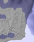 | |||||||||||
— | — | — | — | — | — | 1 | — | — | — | — | — | — | — | — | — | — | |
mm | — | — | 2 | 2 | 2 | — | — | — | — | — | — | — | — | — | — | — | — |
max °C | 7 | 3 | 4 | 4 | 3 | 1 | 0 | -2 | 2 | 0 | 0 | 2 | 0 | 1 | 6 | 5 | 1 |
min °C | 4 | 2 | 4 | 3 | 0 | 1 | -2 | -3 | 0 | -2 | -2 | 1 | 0 | -1 | 3 | 1 | -1 |
chill °C | 2 | -2 | 0 | -1 | -5 | -3 | -7 | -8 | -5 | -6 | -6 | -3 | -4 | -1 | 3 | 1 | -1 |
Humid % | 36 | 60 | 92 | 90 | 91 | 92 | 87 | 94 | 85 | 90 | 94 | 97 | 98 | 97 | 79 | 75 | 84 |
Freeze m | 3000 | 2600 | 2150 | 1950 | 1750 | 1450 | 1300 | 900 | 1350 | 1300 | 1450 | 1700 | 1550 | 1500 | 2000 | 2300 | 2150 |
— | — | 7:11 | — | — | 7:11 | — | — | 7:11 | — | — | 7:09 | — | — | 7:09 | — | — | |
5:13 | — | — | 5:14 | — | — | 5:14 | — | — | 5:15 | — | — | 5:15 | — | — | 5:15 | — | |
Go pro and carve into:
Avalanche information: Mountain Safety Collective
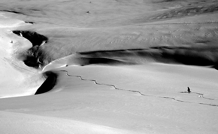
Latest snow reports near Thredbo:
| Top snow depth: | 45 cm |
|---|---|
| Bottom snow depth: | 30 cm |
| Fresh snowfall depth: | — |
| Last snowfall: | 14 Jul 2026 |
| Snow Alerts | Create Alert |
0.0 | Bluebird Powder days Fresh snow, mostly sunny, light wind. |
|---|---|
0.4 | Powder days Fresh snow, limited sun, any wind. |
0.0 | Bluebird days Average snow, mostly sunny, light wind. |


The above table gives the weather forecast for Thredbo at the specific elevation of 1365 m. Our sophisticated weather models allow us to provide snow forecasts for the top, middle and bottom ski stations of Thredbo. To access the weather forecasts for the other elevations, use the tab navigation above the table. For a wider view of the weather, check out the Weather Map of Australia.
Click here to read further information on freezing levels and how we forecast our temperatures.
Overall 3.2 Based on 30 votes and 44 reviews
After skiing in over 20 resorts in North America from December 2017 until April 2018, I have to say that Thredbo stacks up well. It would be nice if it were steeper but in so many ways Thredbo offers a great skiing experience., especially for families. Ticket prices are much cheaper than in the big resorts in North America, especially when taking the exchange rate into account. And Thredbo's snow making keeps the resort running when many in North America do not have the capacity to do so. In Thredbo car parking is free and within walking distance of the lifts. In the USA many resorts have you paying to park and then you wait for a bus or gondola to get you to the lifts. Thredbo's grooming is always excellent and the off-piste runs might often be short, but are rewarding. From my experience there are more rocks in the Rockies than at Thredbo, except the Canadian Rockies. And yes, Thredbo does get good dry powder and good dry windblown. It was a surprise for me that you could spend a week in a big name resort in peak season and not get a powder day. And often the new snow there is sticky and heavy. In North America we used Snow Forecast every day for our trip planning and found the data accurate and invaluable, as in Japan and at home. Thanks, Ted.
Ted from Australia writes:
After skiing in over 20 resorts in North America from December 2017 until April 2018, I have to say that Thredbo stacks up well. It would be nice if it were steeper but in so many ways Thredbo offers a great skiing experience., especially for families.
Ticket prices are much cheaper than in the big resorts in North America, especially when taking the exchange rate into account. And Thredbo's snow making keeps the resort running when many in North America do not have the capacity to do so.
In Thredbo car parking is free and within walking distance of the lifts. In the USA many resorts have you paying to park and then you wait for a bus or gondola to get you to the lifts.
Thredbo's grooming is always excellent and the off-piste runs might often be short, but are rewarding. From my experience there are more rocks in the Rockies than at Thredbo, except the Canadian Rockies.
And yes, Thredbo does get good dry powder and good dry windblown. It was a surprise for me that you could spend a week in a big name resort in peak season and not get a powder day. And often the new snow there is sticky and heavy.
In North America we used Snow Forecast every day for our trip planning and found the data accurate and invaluable, as in Japan and at home. Thanks, Ted.


 Nearest