

Portillo Re-Opens To Guests Arriving By Helicopter
Chile’s famous Portillo ski resort is reported to have re-opened to guests arriving by helicopter after being cut off by road for more than two weeks by over 6m/20 feet of snowfall.

Next 3 days weather summary:Moderate rain (total 13.0mm), heaviest on Mon morning. Warm (max 20°C on Wed afternoon, min 11°C on Mon night). Winds decreasing (near gales from the WNW on Mon night, light winds from the WSW by Tue night). | Days 4-6 weather summary:Moderate rain (total 10.0mm), heaviest on Thu night. Warm (max 23°C on Thu afternoon, min 17°C on Fri night). Wind will be generally light. | |||||||||||||||||
Monday 3 | Tuesday 4 | Wednesday 5 | Thursday 6 | Friday 7 | Saturday 8 | |||||||||||||
AM | PM | night | AM | PM | night | AM | PM | night | AM | PM | night | AM | PM | night | AM | PM | night | |
t-storm risk | mod. rain | rain shwrs | clear | clear | clear | some clouds | cloudy | some clouds | clear | cloudy | rain shwrs | t-storm risk | t-storm risk | rain shwrs | some clouds | t-storm risk | rain shwrs | |
km/h | ||||||||||||||||||
Snow map |  |  |  |  |  |  | ||||||||||||
— | — | — | — | — | — | — | — | — | — | — | — | — | — | — | — | — | — | |
mm | 5 | 7 | 1 | — | — | — | — | — | — | — | — | 2 | 1 | 2 | 2 | — | 2 | 1 |
max °C | 17 | 18 | 12 | 15 | 19 | 18 | 19 | 20 | 19 | 20 | 23 | 20 | 20 | 21 | 19 | 18 | 19 | 19 |
min °C | 17 | 14 | 11 | 14 | 17 | 16 | 17 | 20 | 17 | 18 | 22 | 18 | 19 | 20 | 17 | 17 | 19 | 17 |
chill °C | 15 | 11 | 6 | 12 | 16 | 16 | 17 | 20 | 17 | 18 | 22 | 17 | 19 | 20 | 16 | 16 | 19 | 17 |
Humid % | 96 | 97 | 78 | 56 | 44 | 54 | 43 | 48 | 65 | 67 | 68 | 81 | 79 | 80 | 82 | 88 | 82 | 87 |
Freeze m | 4550 | 4050 | 3750 | 4600 | 4750 | 4800 | 4750 | 4900 | 4650 | 4550 | 4550 | 4700 | 4550 | 4450 | 4300 | 4300 | 4300 | 4550 |
5:39 | — | — | 5:39 | — | — | 5:41 | — | — | 5:41 | — | — | 5:43 | — | — | 5:45 | — | — | |
— | — | 8:13 | — | — | 8:12 | — | — | 8:10 | — | — | 8:08 | — | — | 8:07 | — | — | 8:07 | |
Go pro and carve into:
Avalanche information: National Avalanche Center
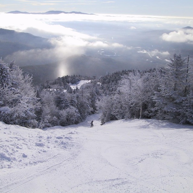
Latest snow reports near Stowe:
| Top snow depth: | 0 cm |
|---|---|
| Bottom snow depth: | 0 cm |
| Fresh snowfall depth: | — |
| Last snowfall: | 2 May 2026 |
| Snow Alerts | Create Alert |
0.0 | Bluebird Powder days Fresh snow, mostly sunny, light wind. |
|---|---|
0.0 | Powder days Fresh snow, limited sun, any wind. |
0.0 | Bluebird days Average snow, mostly sunny, light wind. |
The above table gives the weather forecast for Stowe at the specific elevation of 1109 m. Our sophisticated weather models allow us to provide snow forecasts for the top, middle and bottom ski stations of Stowe. To access the weather forecasts for the other elevations, use the tab navigation above the table. For a wider view of the weather, check out the Weather Map of United States.
Click here to read further information on freezing levels and how we forecast our temperatures.
Overall 3.9 Based on 17 votes and 9 reviews
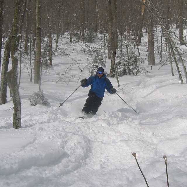
it was said best in 2003: "Stowe is probably the closest you can come to western skiing in the East, unless you have skied at Tuckerman Ravine. But the best of Stowe is not on the trail map, other than Goat, Lookout and Starr, but off piste." The locals take pride in their off-piste skiing from Vermont's highest peak! I am really not sure why Stowe get's so much flack for long lift lines. Have you ever been to the other areas on a busy day? Same lift line except it takes you twice as long to get to the top of the mountain and you may still have to take another lift to get to the top. You can ski twice if not 3X the vertical in one day at Stowe when compared to the other areas in Vermont. Yes, each area has it's own unique charm, but no one matches the skiing at Stowe. Not even close. [note from the editor: names not included in reviews.]
DH from United States writes:
it was said best in 2003: "Stowe is probably the closest you can come to western skiing in the East, unless you have skied at Tuckerman Ravine. But the best of Stowe is not on the trail map, other than Goat, Lookout and Starr, but off piste." The locals take pride in their off-piste skiing from Vermont's highest peak! I am really not sure why Stowe get's so much flack for long lift lines. Have you ever been to the other areas on a busy day? Same lift line except it takes you twice as long to get to the top of the mountain and you may still have to take another lift to get to the top. You can ski twice if not 3X the vertical in one day at Stowe when compared to the other areas in Vermont. Yes, each area has it's own unique charm, but no one matches the skiing at Stowe. Not even close.
[note from the editor: names not included in reviews.]


 Nearest