

America’s Next Indoor Snow Centre Takes Shape
Construction of a new indoor snow centre for skiers, boarders and tubers appears to be making good progress at Heritage Farm in Wayne County, West Virginia.

Next 3 days weather summary:A light covering of new snow, mostly falling on Thu night. Freeze-thaw conditions (max 2°C on Tue afternoon, min 0°C on Wed morning). Winds increasing (light winds from the NW on Wed morning, fresh winds from the NW by Thu afternoon). | Days 4-6 weather summary:A heavy fall of snow, heaviest during Fri afternoon. Temperatures will be below freezing (max -1°C on Fri afternoon, min -9°C on Sat night). Wind will be generally light. | ||||||||||||||||
Tue 21 | Wednesday 22 | Thursday 23 | Friday 24 | Saturday 25 | Sunday 26 | ||||||||||||
PM | night | AM | PM | night | AM | PM | night | AM | PM | night | AM | PM | night | AM | PM | night | |
cloudy | some clouds | some clouds | some clouds | some clouds | light snow | snow shwrs | light snow | snow shwrs | mod. snow | light snow | light snow | light snow | mod. snow | light snow | snow shwrs | some clouds | |
km/h | |||||||||||||||||
Snow map |  | 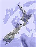 | 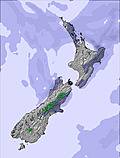 |  |  | 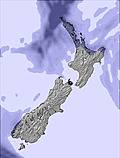 | |||||||||||
— | — | — | — | — | — | — | 4 | — | 6 | 2 | 1 | 4 | 7 | 1 | — | — | |
mm | — | — | — | — | — | — | — | — | — | — | — | — | — | — | — | — | — |
max °C | 2 | 2 | 0 | 0 | 0 | 0 | 1 | 0 | 0 | -1 | -2 | -4 | -6 | -7 | -9 | -8 | -7 |
min °C | 2 | 1 | 0 | 0 | 0 | 0 | 0 | 0 | 0 | -1 | -4 | -5 | -7 | -9 | -9 | -9 | -9 |
chill °C | -1 | -2 | -2 | -3 | -4 | -6 | -7 | -6 | -6 | -7 | -6 | -5 | -7 | -13 | -12 | -14 | -14 |
Humid % | 39 | 56 | 79 | 85 | 71 | 73 | 79 | 89 | 77 | 92 | 92 | 89 | 96 | 97 | 96 | 73 | 56 |
Freeze m | 2100 | 1950 | 1800 | 1750 | 1750 | 1800 | 1850 | 1700 | 1650 | 1550 | 1300 | 1100 | 900 | 500 | 350 | 500 | 0 |
— | — | 8:02 | — | — | 8:00 | — | — | 8:00 | — | — | 7:58 | — | — | 7:58 | — | — | |
5:23 | — | — | 5:24 | — | — | 5:25 | — | — | 5:27 | — | — | 5:28 | — | — | 5:29 | — | |
Go pro and carve into:
Avalanche information: New Zealand Avalanche Advisory
Latest snow reports near Roundhill:
| Top snow depth: | — |
|---|---|
| Bottom snow depth: | — |
| Fresh snowfall depth: | — |
| Last snowfall: | 15 Jul 2026 |
| Snow Alerts | Create Alert |
0.5 | Bluebird Powder days Fresh snow, mostly sunny, light wind. |
|---|---|
1.2 | Powder days Fresh snow, limited sun, any wind. |
1.8 | Bluebird days Average snow, mostly sunny, light wind. |
The above table gives the weather forecast for Roundhill at the specific elevation of 1742 m. Our sophisticated weather models allow us to provide snow forecasts for the top, middle and bottom ski stations of Roundhill. To access the weather forecasts for the other elevations, use the tab navigation above the table. For a wider view of the weather, check out the Weather Map of New Zealand.
Click here to read further information on freezing levels and how we forecast our temperatures.
Overall 3.4 Based on 3 votes and 9 reviews
Great skifield for learners as the terrain is wide and open. The mountain is well-organised and the grooming is impeccable. Now the cons. Alcohol is freely used by the public and is also sold on the mountain, as the field is essentially family-oriented I am uncomfortable with alcohol being openly consumed around children. During special event days, there is very little connection and involvement with mountain management.
Sanatana from New Zealand writes:
Great skifield for learners as the terrain is wide and open. The mountain is well-organised and the grooming is impeccable. Now the cons. Alcohol is freely used by the public and is also sold on the mountain, as the field is essentially family-oriented I am uncomfortable with alcohol being openly consumed around children. During special event days, there is very little connection and involvement with mountain management.


 Nearest