


Banff Sunshine Village Opening for Summer Skiing
Banff Sunshine Village has confirmed it will reopen for a fortnight of summer skiing, from this weekend. The only ski area in Canada to be open into July.

Next 4 days weather summary:A light covering of new snow, mostly falling on Wed afternoon. Freeze-thaw conditions (max 2°C on Mon morning, min -2°C on Mon night). Wind will be generally light. | Days 5-7 weather summary:A heavy fall of snow, heaviest during Thu night. Temperatures will be below freezing (max 0°C on Wed night, min -5°C on Sat afternoon). Wind will be generally light. | |||||||||||||||
Monday 22 | Tuesday 23 | Wednesday 24 | Thursday 25 | Friday 26 | ||||||||||||
night | AM | PM | night | AM | PM | night | AM | PM | night | AM | PM | night | AM | PM | night | |
clear | clear | clear | some clouds | clear | some clouds | cloudy | light snow | mod. snow | heavy snow | light snow | light snow | heavy snow | light snow | light snow | light snow | |
km/h | ||||||||||||||||
Snow map |  | 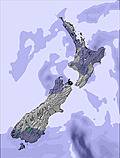 | 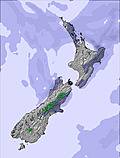 |  |  | 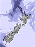 | ||||||||||
— | — | — | — | — | — | — | — | 8 | 10 | 3 | 2 | 16 | 4 | 5 | 2 | |
mm | — | — | — | — | — | — | — | — | — | — | — | — | — | — | — | — |
max °C | 0 | 2 | 2 | -1 | 1 | 1 | 0 | 0 | 0 | 0 | -2 | -2 | -2 | -2 | -2 | -3 |
min °C | -1 | 0 | 0 | -2 | -1 | -1 | -1 | 0 | -1 | -2 | -3 | -2 | -3 | -3 | -2 | -4 |
chill °C | -1 | -2 | -3 | -6 | -5 | -5 | -3 | -2 | -3 | -5 | -7 | -7 | -8 | -8 | -6 | -7 |
Humid % | 56 | 50 | 69 | 81 | 80 | 74 | 66 | 72 | 100 | 100 | 98 | 99 | 99 | 98 | 98 | 98 |
Freeze m | 1800 | 1750 | 2050 | 1400 | 1350 | 1650 | 1600 | 1700 | 1500 | 1550 | 1100 | 1100 | 1200 | 1050 | 1150 | 1050 |
— | 8:08 | — | — | 8:10 | — | — | 8:10 | — | — | 8:10 | — | — | 8:10 | — | — | |
— | — | 5:06 | — | — | 5:06 | — | — | 5:07 | — | — | 5:07 | — | — | 5:07 | — | |
Go pro and carve into:
Avalanche information: New Zealand Avalanche Advisory
Latest snow reports near HeliPark New Zealand:
| Top snow depth: | — |
|---|---|
| Bottom snow depth: | — |
| Fresh snowfall depth: | — |
| Last snowfall: | 19 Jun 2026 |
| Snow Alerts | Create Alert |
0.1 | Bluebird Powder days Fresh snow, mostly sunny, light wind. |
|---|---|
0.6 | Powder days Fresh snow, limited sun, any wind. |
0.6 | Bluebird days Average snow, mostly sunny, light wind. |
The above table gives the weather forecast for HeliPark New Zealand at the specific elevation of 1449 m. Our sophisticated weather models allow us to provide snow forecasts for the top, middle and bottom ski stations of HeliPark New Zealand. To access the weather forecasts for the other elevations, use the tab navigation above the table. For a wider view of the weather, check out the Weather Map of New Zealand.
Click here to read further information on freezing levels and how we forecast our temperatures.
No matter were in the world you ski / ride its all great, its all about what you make of it, but this place ( MT-POTTS ) makes it for you, were eles in the world can you chopper in, cat ski ( 14 runs on agood day )and get a beer at the end of the day all for $ 320 NZ, SIMPLE YOU CANT. The snow they get is very dry and man they get snow.I shouldnt be telling you this or you will all want to come.
JONATHAN from New Zealand writes:
No matter were in the world you ski / ride its all great, its all about what you make of it, but this place ( MT-POTTS ) makes it for you, were eles in the world can you chopper in, cat ski ( 14 runs on agood day )and get a beer at the end of the day all for $ 320 NZ, SIMPLE YOU CANT. The snow they get is very dry and man they get snow.I shouldnt be telling you this or you will all want to come.
Click here to submit your own review of HeliPark New Zealand


 Nearest