

Banff Sunshine Village Opening for Summer Skiing
Banff Sunshine Village has confirmed it will reopen for a fortnight of summer skiing, from this weekend. The only ski area in Canada to be open into July.

Next 3 days weather summary:Moderate rain (total 10.0mm), heaviest on Sat night. Mild temperatures (max 6°C on Sat morning, min 2°C on Mon morning). Winds decreasing (gales from the WNW on Sat night, light winds from the S by Sun night). | Days 4-6 weather summary:Heavy rain (total 52.0mm), heaviest during Wed morning. Temperatures will be slightly above freezing (max 4°C on Tue afternoon, min 3°C on Tue morning). Winds decreasing (gales from the NNE on Wed morning, light winds from the NNW by Wed night). | |||||||||||||||||
Saturday 20 | Sunday 21 | Monday 22 | Tuesday 23 | Wednesday 24 | Thursday 25 | |||||||||||||
AM | PM | night | AM | PM | night | AM | PM | night | AM | PM | night | AM | PM | night | AM | PM | night | |
some clouds | light rain | mod. rain | clear | clear | clear | clear | clear | some clouds | some clouds | light rain | heavy rain | heavy rain | rain shwrs | clear | clear | clear | clear | |
km/h | ||||||||||||||||||
Snow map |  |  |  |  |  |  | ||||||||||||
— | — | — | — | — | — | — | — | — | — | — | — | — | — | — | — | — | — | |
mm | — | 2 | 8 | — | — | — | — | — | — | — | 2 | 13 | 30 | 7 | — | — | — | — |
max °C | 6 | 6 | 6 | 5 | 5 | 4 | 2 | 2 | 3 | 3 | 4 | 4 | 4 | 4 | 3 | 4 | 4 | 4 |
min °C | 6 | 6 | 5 | 5 | 4 | 3 | 2 | 2 | 2 | 3 | 4 | 3 | 3 | 3 | 3 | 3 | 3 | 3 |
chill °C | 0 | 0 | -1 | 0 | -1 | -2 | -2 | -2 | -4 | -3 | -3 | -4 | -5 | -1 | 0 | 1 | 0 | -2 |
Humid % | 81 | 86 | 94 | 85 | 75 | 64 | 53 | 60 | 85 | 83 | 97 | 92 | 98 | 92 | 61 | 62 | 65 | 71 |
Freeze m | 3800 | 3500 | 3200 | 2500 | 2450 | 2500 | 2300 | 2250 | 2150 | 2250 | 2350 | 2350 | 2350 | 2350 | 2200 | 2200 | 2200 | 2250 |
7:43 | — | — | 7:43 | — | — | 7:43 | — | — | 7:43 | — | — | 7:43 | — | — | 7:43 | — | — | |
— | 5:06 | — | — | 5:07 | — | — | 5:07 | — | — | 5:07 | — | — | 5:07 | — | — | 5:07 | — | |
Go pro and carve into:
Avalanche information: New Zealand Avalanche Advisory
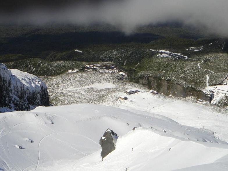
Latest snow reports near Manganui:
| Top snow depth: | — |
|---|---|
| Bottom snow depth: | — |
| Fresh snowfall depth: | — |
| Last snowfall: | 21 Apr 2026 |
| Snow Alerts | Create Alert |
0.1 | Bluebird Powder days Fresh snow, mostly sunny, light wind. |
|---|---|
0.1 | Powder days Fresh snow, limited sun, any wind. |
0.6 | Bluebird days Average snow, mostly sunny, light wind. |


The above table gives the weather forecast for Manganui at the specific elevation of 1679 m. Our sophisticated weather models allow us to provide snow forecasts for the top, middle and bottom ski stations of Manganui. To access the weather forecasts for the other elevations, use the tab navigation above the table. For a wider view of the weather, check out the Weather Map of New Zealand.
Click here to read further information on freezing levels and how we forecast our temperatures.
Overall 2.7 Based on 3 votes and 3 reviews
A family friendly field, with a little effort required to get skiing (walk of 20min, 10 min to good lift). Sealed road all the way to car park. Lots of snowboarders - in fact they tend to outnumber skiers in this surfer dominated province. Some of the cheapest skiing/boarding in NZ - full lift pass is NZ$40! No frills skiing. Some exhilarating lines on "top-tow" when it is operating. Public Day Lodge and new Club Lodge for SMC Club members. Club Lodge is, however, open to the public for accommodation on mountain (sleeps 30) - you need to book.
Binnybarbs from New Zealand writes:
A family friendly field, with a little effort required to get skiing (walk of 20min, 10 min to good lift). Sealed road all the way to car park. Lots of snowboarders - in fact they tend to outnumber skiers in this surfer dominated province. Some of the cheapest skiing/boarding in NZ - full lift pass is NZ$40! No frills skiing. Some exhilarating lines on "top-tow" when it is operating. Public Day Lodge and new Club Lodge for SMC Club members. Club Lodge is, however, open to the public for accommodation on mountain (sleeps 30) - you need to book.


 Nearest