


America’s Next Indoor Snow Centre Takes Shape
Construction of a new indoor snow centre for skiers, boarders and tubers appears to be making good progress at Heritage Farm in Wayne County, West Virginia.

Next 3 days weather summary:Light rain (total 4.0mm), mostly falling on Wed afternoon. Very mild (max 16°C on Fri afternoon, min 7°C on Wed night). Winds decreasing (near gales from the W on Wed night, light winds from the SSW by Fri night). | Days 4-6 weather summary:Light rain (total 4.0mm), mostly falling on Mon morning. Warm (max 20°C on Sun afternoon, min 13°C on Mon night). Wind will be generally light. | ||||||||||||||||
Wed 22 | Thursday 23 | Friday 24 | Saturday 25 | Sunday 26 | Monday 27 | ||||||||||||
PM | night | AM | PM | night | AM | PM | night | AM | PM | night | AM | PM | night | AM | PM | night | |
light rain | rain shwrs | some clouds | cloudy | clear | clear | clear | clear | clear | clear | some clouds | some clouds | some clouds | cloudy | light rain | light rain | some clouds | |
km/h | |||||||||||||||||
Snow map |  |  |  |  |  |  | |||||||||||
— | — | — | — | — | — | — | — | — | — | — | — | — | — | — | — | — | |
mm | 3 | 1 | — | — | — | — | — | — | — | — | — | — | — | — | 1 | 1 | — |
max °C | 10 | 8 | 10 | 13 | 13 | 14 | 16 | 15 | 16 | 19 | 18 | 17 | 20 | 17 | 15 | 14 | 14 |
min °C | 9 | 7 | 8 | 12 | 12 | 13 | 15 | 14 | 15 | 18 | 16 | 16 | 19 | 15 | 14 | 14 | 13 |
chill °C | 4 | 2 | 4 | 9 | 10 | 12 | 15 | 14 | 14 | 18 | 15 | 16 | 19 | 13 | 12 | 12 | 12 |
Humid % | 94 | 59 | 60 | 57 | 54 | 57 | 55 | 58 | 56 | 43 | 62 | 53 | 46 | 65 | 83 | 73 | 84 |
Freeze m | 3200 | 3300 | 2700 | 2950 | 2850 | 3100 | 3500 | 3700 | 3950 | 3950 | 3400 | 3500 | 3550 | 3600 | 3500 | 3650 | 3600 |
— | — | 5:24 | — | — | 5:24 | — | — | 5:26 | — | — | 5:26 | — | — | 5:28 | — | — | |
— | 8:27 | — | — | 8:25 | — | — | 8:24 | — | — | 8:23 | — | — | 8:22 | — | — | 8:22 | |
Go pro and carve into:
Avalanche information: National Avalanche Center
Latest snow reports near Jay Peak:
| Top snow depth: | — |
|---|---|
| Bottom snow depth: | — |
| Fresh snowfall depth: | — |
| Last snowfall: | 29 May 2026 |
| Snow Alerts | Create Alert |
0.0 | Bluebird Powder days Fresh snow, mostly sunny, light wind. |
|---|---|
0.0 | Powder days Fresh snow, limited sun, any wind. |
0.0 | Bluebird days Average snow, mostly sunny, light wind. |
The above table gives the weather forecast for Jay Peak at the specific elevation of 1209 m. Our sophisticated weather models allow us to provide snow forecasts for the top, middle and bottom ski stations of Jay Peak. To access the weather forecasts for the other elevations, use the tab navigation above the table. For a wider view of the weather, check out the Weather Map of United States.
Click here to read further information on freezing levels and how we forecast our temperatures.
Overall 3.8 Based on 23 votes and 9 reviews
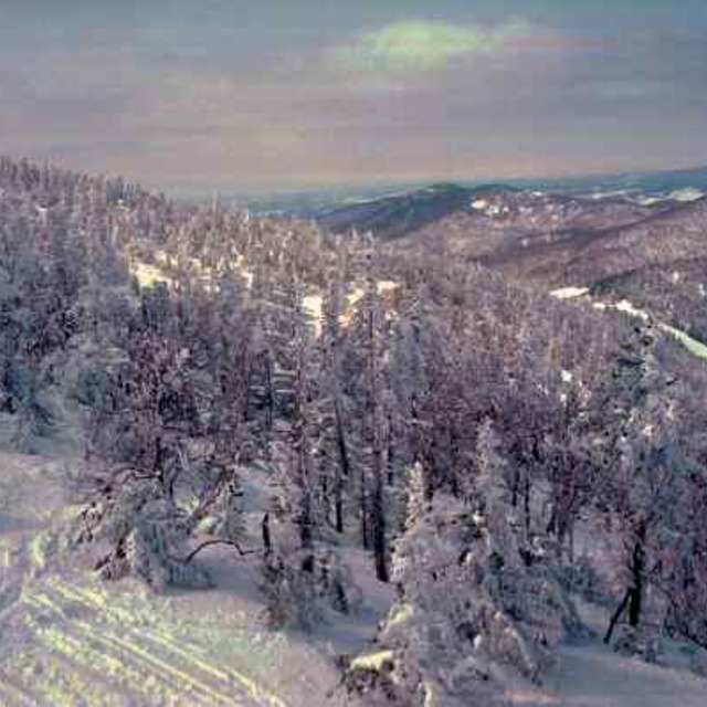
I have been skiing 30 plus years and I have skied all over the USA and Canada East to West. Jay peak is in a league of its own for snow quality and quantity compared to any other eastern ski resort. I have had just as many powder days at Jay peak as I have had at SnowMass or Alta. The difference with those places is they are way bigger, so less tracked up and snow stays for days and weeks as powder due to elevation. With Jay you have to plan around the weather and when it dumps stay there a few days, it won’t disappoint. It’s honestly as gnarly as it gets.
Chris Marciano from United States writes:
I have been skiing 30 plus years and I have skied all over the USA and Canada East to West. Jay peak is in a league of its own for snow quality and quantity compared to any other eastern ski resort. I have had just as many powder days at Jay peak as I have had at SnowMass or Alta. The difference with those places is they are way bigger, so less tracked up and snow stays for days and weeks as powder due to elevation. With Jay you have to plan around the weather and when it dumps stay there a few days, it won’t disappoint. It’s honestly as gnarly as it gets.


 Nearest