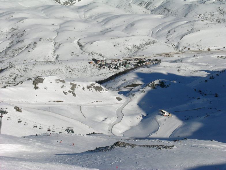


A New Largest Ski Area in New Zealand?
The Remarkables is hoping to overtake Cardrona as New Zealand’s largest ski area under a major NZD 150 million‑plus expansion proposal lodged by owner NZSki.

Next 3 days weather summary:Light rain (total 2.0mm), mostly falling on Thu morning. Warm (max 25°C on Wed afternoon, min 12°C on Fri morning). Winds increasing (light winds from the SE on Wed afternoon, fresh winds from the S by Thu afternoon). | Days 4-6 weather summary:Mostly dry. Very mild (max 19°C on Mon afternoon, min 11°C on Sat night). Wind will be generally light. | ||||||||||||||||
Wed 24 | Thursday 25 | Friday 26 | Saturday 27 | Sunday 28 | Monday 29 | ||||||||||||
PM | night | AM | PM | night | AM | PM | night | AM | PM | night | AM | PM | night | AM | PM | night | |
some clouds | some clouds | rain shwrs | rain shwrs | clear | clear | some clouds | some clouds | clear | clear | some clouds | some clouds | some clouds | some clouds | clear | clear | clear | |
km/h | |||||||||||||||||
Snow map |  | 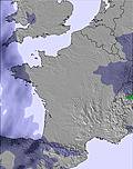 | 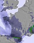 | 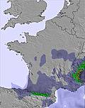 | 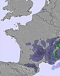 |  | |||||||||||
— | — | — | — | — | — | — | — | — | — | — | — | — | — | — | — | — | |
mm | — | — | 1 | 1 | — | — | — | — | — | — | — | — | — | — | — | — | — |
max °C | 25 | 22 | 16 | 17 | 16 | 13 | 18 | 17 | 14 | 17 | 15 | 14 | 16 | 14 | 16 | 19 | 17 |
min °C | 24 | 19 | 16 | 15 | 13 | 12 | 16 | 15 | 13 | 16 | 11 | 11 | 15 | 12 | 14 | 19 | 14 |
chill °C | 24 | 19 | 15 | 13 | 11 | 10 | 14 | 14 | 11 | 15 | 11 | 11 | 15 | 11 | 14 | 19 | 14 |
Humid % | 25 | 44 | 61 | 41 | 58 | 62 | 50 | 57 | 59 | 38 | 84 | 74 | 73 | 70 | 60 | 58 | 57 |
Freeze m | 4650 | 4600 | 4050 | 3750 | 3850 | 4000 | 3850 | 4050 | 3750 | 3950 | 4100 | 4100 | 4100 | 4450 | 4450 | 4500 | 4650 |
— | — | 6:43 | — | — | 6:43 | — | — | 6:43 | — | — | 6:43 | — | — | 6:43 | — | — | |
— | 10:04 | — | — | 10:04 | — | — | 10:05 | — | — | 10:05 | — | — | 10:05 | — | — | 10:04 | |
Go pro and carve into:
Avalanche information: European Avalanche Warning Services (EAWS)
Latest snow reports near Fuentes de Invierno:
| Top snow depth: | 0 cm |
|---|---|
| Bottom snow depth: | 0 cm |
| Fresh snowfall depth: | — |
| Last snowfall: | 15 May 2026 |
| Snow Alerts | Create Alert |
0.0 | Bluebird Powder days Fresh snow, mostly sunny, light wind. |
|---|---|
0.0 | Powder days Fresh snow, limited sun, any wind. |
0.0 | Bluebird days Average snow, mostly sunny, light wind. |


The above table gives the weather forecast for Fuentes de Invierno at the specific elevation of 1726 m. Our sophisticated weather models allow us to provide snow forecasts for the top, middle and bottom ski stations of Fuentes de Invierno. To access the weather forecasts for the other elevations, use the tab navigation above the table. For a wider view of the weather, check out the Weather Map of Spain.
Click here to read further information on freezing levels and how we forecast our temperatures.
Overall 3.2 Based on 33 votes and 3 reviews
Although it is literally next door to San Isidro, the 2 areas couldn't be more different. San Isidro is a beginners mountain with nothing of interest for advanced skiers. Fuentes, however, is a seriously fun mountain for advanced skiers with tons of in-area and out of area off-piste and has some good steep pitches. Amazing amount of skiing for only a few lifts with some short climbing options to some great steep terrain. Not a holiday resort but absolutely worth a visit if you're an advanced skier. The conditions are good and you're in the region.
Mark Cotgrove from Spain writes:
Although it is literally next door to San Isidro, the 2 areas couldn't be more different. San Isidro is a beginners mountain with nothing of interest for advanced skiers. Fuentes, however, is a seriously fun mountain for advanced skiers with tons of in-area and out of area off-piste and has some good steep pitches. Amazing amount of skiing for only a few lifts with some short climbing options to some great steep terrain. Not a holiday resort but absolutely worth a visit if you're an advanced skier. The conditions are good and you're in the region.
Read 2 more reviews of Fuentes de Invierno or submit your own


 Nearest