

Global Weekly Snow Roundup #320
Weekly Snow News for the world, updated 25 June 2026: Chile and New Zealand's seasons proper set to begin, Tignes and Sunshine reopen for summer skiing. weekend as Riksgransen ends its 2026 season.

Next 3 days weather summary:Moderate rain (total 10.0mm), heaviest on Sat night. Warm (max 21°C on Sat afternoon, min 9°C on Sun night). Winds decreasing (fresh winds from the SSW on Sat afternoon, calm by Sun morning). | Days 4-6 weather summary:Mostly dry. Very mild (max 19°C on Tue afternoon, min 8°C on Tue night). Wind will be generally light. | ||||||||||||||||
Sat 27 | Sunday 28 | Monday 29 | Tuesday 30 | Wednesday 1 | Thursday 2 | ||||||||||||
PM | night | AM | PM | night | AM | PM | night | AM | PM | night | AM | PM | night | AM | PM | night | |
some clouds | rain shwrs | some clouds | t-storm risk | light rain | rain shwrs | rain shwrs | some clouds | clear | clear | some clouds | clear | clear | clear | clear | clear | clear | |
km/h | |||||||||||||||||
Snow map | 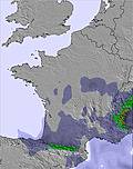 | 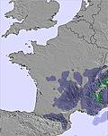 |  |  |  |  | |||||||||||
— | — | — | — | — | — | — | — | — | — | — | — | — | — | — | — | — | |
mm | — | 2 | — | 2 | 3 | 2 | 1 | — | — | — | — | — | — | — | — | — | — |
max °C | 21 | 17 | 15 | 16 | 11 | 12 | 18 | 14 | 16 | 19 | 14 | 12 | 15 | 13 | 15 | 19 | 15 |
min °C | 20 | 11 | 11 | 12 | 9 | 10 | 14 | 11 | 12 | 18 | 8 | 9 | 15 | 9 | 10 | 18 | 10 |
chill °C | 20 | 11 | 11 | 10 | 7 | 9 | 14 | 10 | 12 | 18 | 6 | 7 | 14 | 7 | 8 | 18 | 8 |
Humid % | 48 | 89 | 84 | 97 | 98 | 93 | 64 | 69 | 70 | 66 | 34 | 49 | 65 | 25 | 29 | 38 | 28 |
Freeze m | 4000 | 4050 | 3850 | 3950 | 4100 | 4300 | 4300 | 4550 | 4550 | 4600 | 4600 | 4500 | 4700 | 4850 | 4750 | 4800 | 4750 |
— | — | 6:43 | — | — | 6:43 | — | — | 6:45 | — | — | 6:45 | — | — | 6:46 | — | — | |
— | 10:05 | — | — | 10:05 | — | — | 10:04 | — | — | 10:04 | — | — | 10:04 | — | — | 10:04 | |
Go pro and carve into:
Avalanche information: European Avalanche Warning Services (EAWS)
Latest snow reports near Fuentes de Invierno:
| Top snow depth: | 0 cm |
|---|---|
| Bottom snow depth: | 0 cm |
| Fresh snowfall depth: | — |
| Last snowfall: | 15 May 2026 |
| Snow Alerts | Create Alert |
0.0 | Bluebird Powder days Fresh snow, mostly sunny, light wind. |
|---|---|
0.0 | Powder days Fresh snow, limited sun, any wind. |
0.0 | Bluebird days Average snow, mostly sunny, light wind. |


The above table gives the weather forecast for Fuentes de Invierno at the specific elevation of 1501 m. Our sophisticated weather models allow us to provide snow forecasts for the top, middle and bottom ski stations of Fuentes de Invierno. To access the weather forecasts for the other elevations, use the tab navigation above the table. For a wider view of the weather, check out the Weather Map of Spain.
Click here to read further information on freezing levels and how we forecast our temperatures.
Overall 3.2 Based on 33 votes and 3 reviews
Es una magnífica estación. De dimensiones reducidas, sorprende por la belleza de algunas de sus pistas y por la longitud de la pista de debutantes que llega hasta la parte más baja de la estación. Respetuosa con el medio ambiente (la anchura de sus pistas no es la ideal por esa razón), ofrece un paisaje espléndido a la vista y unos fuera de pista excelentes.
Mark Stem from Spain writes:
Es una magnífica estación. De dimensiones reducidas, sorprende por la belleza de algunas de sus pistas y por la longitud de la pista de debutantes que llega hasta la parte más baja de la estación. Respetuosa con el medio ambiente (la anchura de sus pistas no es la ideal por esa razón), ofrece un paisaje espléndido a la vista y unos fuera de pista excelentes.
Read 2 more reviews of Fuentes de Invierno or submit your own


 Nearest