

Global Weekly Snow Roundup #314
Weekly Global Snow News, updated 14 May 2026: Fresh snowfall in Argentina, Australia and Lesotho signals winter’s approach, while Japan maintains the world’s deepest snowpack.

Next 3 days weather summary:A dusting of snow turning to light rain (total 5.0mm) on Sat afternoon. Freeze-thaw conditions (max 5°C on Sun afternoon, min -2°C on Sat morning). Winds increasing (calm on Sat night, fresh winds from the WSW by Mon afternoon). | Days 4-6 weather summary:Light rain (total 4.0mm), mostly falling on Tue morning. Very mild (max 15°C on Thu afternoon, min 4°C on Tue morning). Winds decreasing (fresh winds from the W on Tue afternoon, calm by Thu morning). | |||||||||||||||||
Saturday 16 | Sunday 17 | Monday 18 | Tuesday 19 | Wednesday 20 | Thursday 21 | |||||||||||||
AM | PM | night | AM | PM | night | AM | PM | night | AM | PM | night | AM | PM | night | AM | PM | night | |
snow shwrs | light snow | cloudy | light snow | rain shwrs | light rain | cloudy | light rain | cloudy | light rain | light rain | some clouds | clear | clear | some clouds | some clouds | clear | clear | |
km/h | ||||||||||||||||||
Snow map |  |  |  |  |  |  | ||||||||||||
1 | — | — | — | — | — | — | — | — | — | — | — | — | — | — | — | — | — | |
— | 1 | — | — | 1 | 1 | — | 2 | — | 2 | 2 | — | — | — | — | — | — | — | |
max °C | -2 | 3 | 3 | 2 | 5 | 4 | 2 | 4 | 3 | 4 | 5 | 7 | 7 | 12 | 11 | 10 | 15 | 15 |
min °C | -2 | 1 | 1 | 1 | 3 | 1 | 1 | 3 | 2 | 4 | 5 | 5 | 7 | 10 | 10 | 10 | 13 | 14 |
-8 | -4 | 1 | -4 | -1 | -4 | -4 | -3 | -4 | -1 | 0 | 1 | 4 | 8 | 9 | 10 | 13 | 14 | |
88 | 56 | 78 | 96 | 80 | 92 | 78 | 80 | 77 | 98 | 95 | 87 | 58 | 42 | 59 | 56 | 44 | 33 | |
1300 | 1950 | 1950 | 1850 | 2300 | 2100 | 2000 | 2100 | 2450 | 2650 | 3000 | 2900 | 3250 | 3250 | 3800 | 3950 | 4100 | 4050 | |
6:16 | — | — | 6:16 | — | — | 6:15 | — | — | 6:13 | — | — | 6:13 | — | — | 6:11 | — | — | |
— | — | 9:12 | — | — | 9:13 | — | — | 9:14 | — | — | 9:15 | — | — | 9:16 | — | — | 9:17 | |
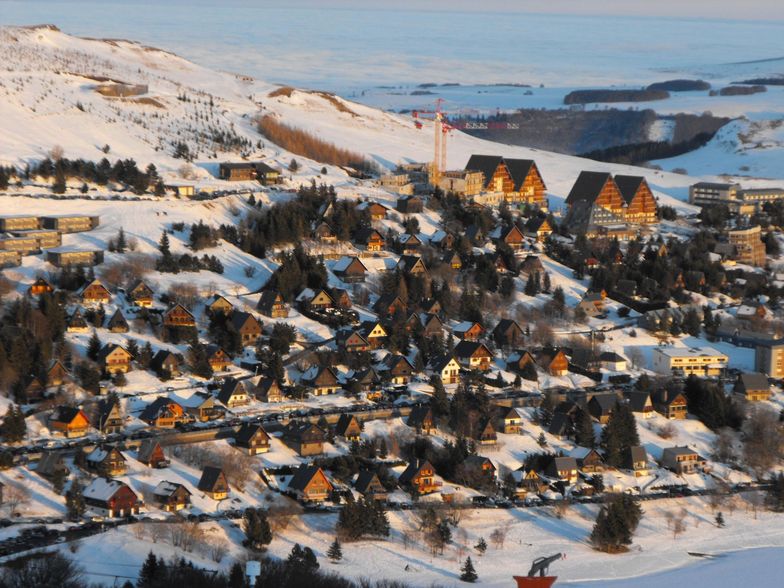
Latest snow reports near Besse Super Besse:
It is snowing steadily in Le Mont-Dore. from Le Mont-Dore
| Top snow depth: | — |
|---|---|
| Bottom snow depth: | — |
| Fresh snowfall depth: | 13 cm |
| Last snowfall: | 15 May 2026 |
| Snow Alerts | Create Alert |
0.0 | Bluebird Powder days Fresh snow, mostly sunny, light wind. |
|---|---|
0.1 | Powder days Fresh snow, limited sun, any wind. |
0.1 | Bluebird days Average snow, mostly sunny, light wind. |
The above table gives the weather forecast for Besse Super Besse at the specific elevation of 1600 m. Our sophisticated weather models allow us to provide snow forecasts for the top, middle and bottom ski stations of Besse Super Besse. To access the weather forecasts for the other elevations, use the tab navigation above the table. For a wider view of the weather, check out the Weather Map of France.
Click here to read further information on freezing levels and how we forecast our temperatures.
Overall 3.8 Based on 18 votes and 4 reviews
The best ski resort at less than 4 hours from Paris (much better than the Vosges or the Jura). Tracks are quite easy but steep enough to get some real good fun. The new speed lifts allow you to warm your thighs by getting on the top in 5 min! The connection to Mont Dore, when the weather is nice, allows you to try one of the best places for extreme free-ride skiing in Europe.
Antoine from France writes:
The best ski resort at less than 4 hours from Paris (much better than the Vosges or the Jura).
Tracks are quite easy but steep enough to get some real good fun. The new speed lifts allow you to warm your thighs by getting on the top in 5 min!
The connection to Mont Dore, when the weather is nice, allows you to try one of the best places for extreme free-ride skiing in Europe.


 Nearest