WORLD SNOW ROUNDUP #229
Issued: 14th February 2024
By Patrick “Snowhunter” Thorne
World Overview
After the drama of the huge snowfalls in California and Norway last week it’s been a much calmer 7-day period in the world’s leading ski areas. The big news really has been the return of colder weather and snowfall – if not yet as much as forecasting models predicted – in the Alps and Pyrenees after a long warm and dry midwinter weather spell. There has also been more snow in Scandinavia, where conditions remain excellent in most areas and powder days were reported in the Rockies with more snowfall there. Ski areas in very southerly US states like Arizona and New Mexico have been reporting they have had plenty of powder too but it continues to be touch and go in the Northwest of the continent with ski areas in parts of Montana, Washington state and BC in Canada all struggling, so much so one has now called it a day on the 23-243 season and say they’ll try again next winter.
Europe
EUROPE INTRO
The snow has returned to western Europe at last after three weeks of very warm temperatures and mostly sunny skies. Snowfall was reported on glaciers from last Wednesday and then has continued down to lower levels, reported at 1,000m by the weekend. Along with the snow came more dynamic weather conditions, with gusting winds closing slopes at times. There have not been many of the bigger numbers for snowfall totals that forecasting models were predicting a week ago, it has been more 10cm (4″) here, 20cm (8″) there in each 24 hours and valley temperatures have mostly bounced back up to 7-9C so there’s it has not been a full respite as yet, but on higher slopes at 2000m and above its been more consistently subzero and conditions are great on the piste, with even a little freeriding terrain to be found again off the groomed runs.
Beyond the Alps, the Pyrenees – which had had warm, sunny conditions for longer – have seen a return to subzero temperatures and 20-40cm (8-16”) snow accumulations. Bulgaria unfortunately saw heavy rain leading to World Cup races being cancelled (yet again) on Sunday. Scotland doesn’t have a lot open still but conditions are currently improving and Scandinavia is still reaping the rewards of Storm Ingunn with good snow across the region, deepest in the west.
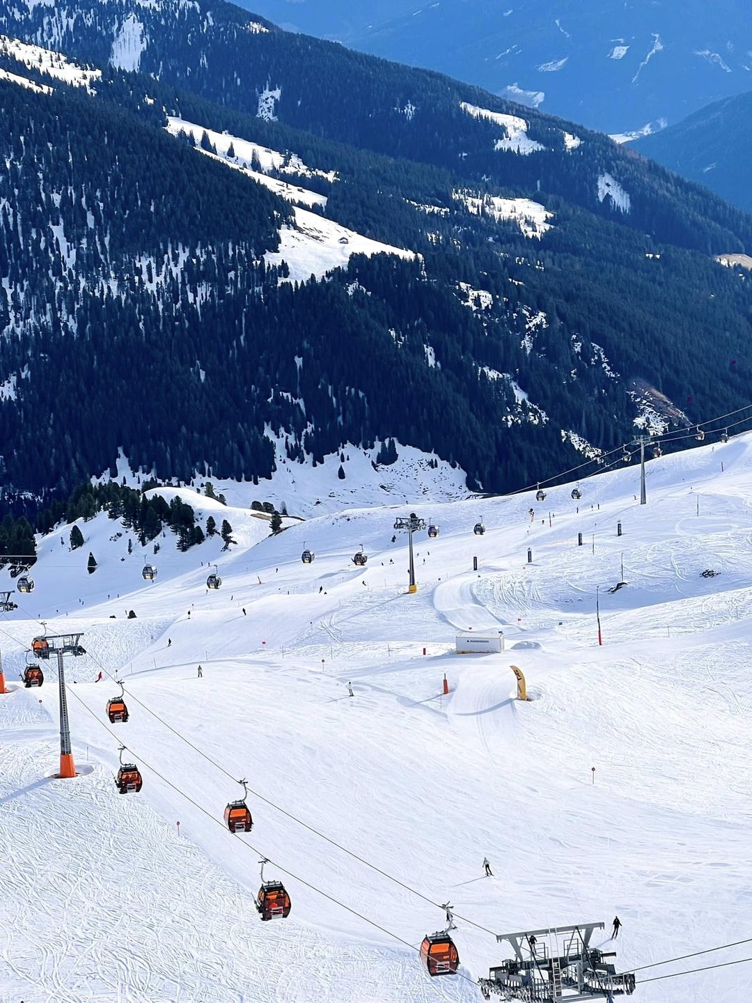
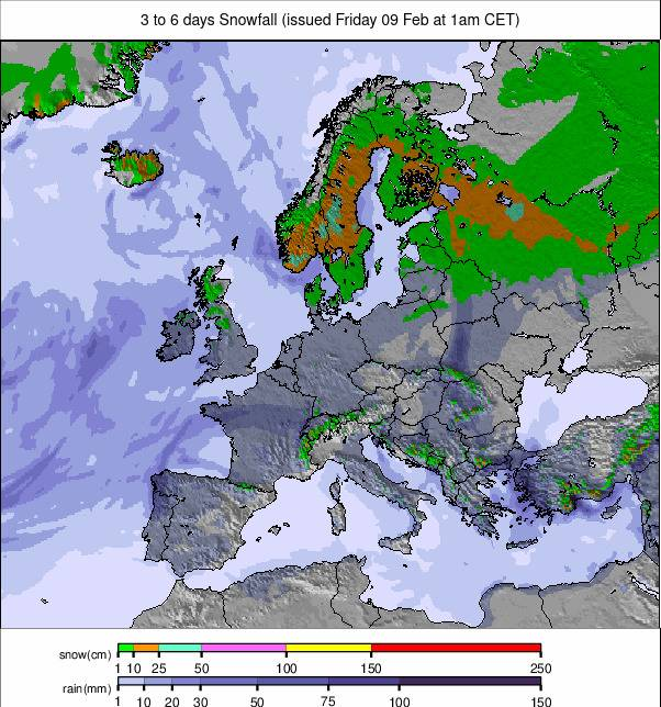
Image: European snowfall summary overview for the next 3-6 days.
AUSTRIA REPORT
The colder weather expected for Austrian slopes has arrived but the snowfall has not really materialised, unfortunately, just a few centimetres here and there, making little impact on snow depths or re-energising the off-piste. But most of the country’s ski slopes remain open and resorts are happy to promote good piste skiing in cooler temperatures. Not that they’re that cool. We did get freezing down to valley floors at the weekends but these have crept back up to +5 or 6 at 1,000m, freezing up at 15000-2000m through the 24-hour cycle. That’s better than it was but not exactly wintery. Most centres remain fully open anyway. The Arlberg around Lech and St Anton (65/355cm / 26/142″) is at 93% and the most moist in the country. The Kaunertal Glacier (210/360cm / 84/144”) has the deepest reported snow.
AUSTRIA FORECAST
Not a lot of change now with very little snow forecast, although the potential is there. A mixture of sunny and overcast days ahead with light snow showers. Overnight lows of -10C on high peaks, daytime highs of +8C in lower valleys.
SWITZERLAND REPORT
Swiss resorts posted some of the best snowfall numbers in the first days of the weather change at the end of last week, many reporting 10-20cm (4-8”) of fresh snow cover after weeks of warm weather and dry conditions. The weather remained unsettled through the weekend as the Foehn wind died away to allow colder, windier weather in. Regardless, base depths remain good at most resorts and slope depths decent above 1500m, and particularly above 2000m. Base depths are up a little at Laax (15/375cm / 6/150″), which is the country’s thickest snowpack while the 4 Valleys around Verbier (20/255cm / 8/102″) remain 98% open with 390km (243 miles) of slopes available to ski or board, still the most entirely within Switzerland.
SWITZERLAND FORECAST
There’s quite a lot of uncertainty for the week ahead with the potential for plenty of snowfall later this week if things develop as expected, however, it may turn out drier than expected and valley temperatures are already creeping back up towards double figures unfortunately.
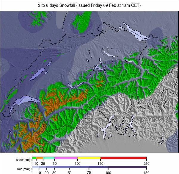
Image: Switzerland snowfall forecast for the next 3-6 days.
FRANCE REPORT
French ski areas saw snowfall down to low elevations, including resort level at some lower centres like Les Gets, as the weather changed and snowfall moved in at the weekend. It kept snowing into the start of this week with unsettled conditions also bringing windy weather at times. The refresh on the piste was very welcome and there’s also been the chance to do a little freeriding too, although inevitably the avalanche danger has climbed too. There’s not much change in reported base depths, with France continuing to be the only country with several resorts posting bases over 4 metres (13.3 feet) up high. The Chamonix Valley (30/450cm / 12/180″) tops the table at Grands Montets with Flaine (0/410cm / 0/164”) and Les Arcs (50/410cm / 20/164”) also in the four-metre club. Most French areas remain more than 90% open.
FRANCE FORECAST
Unfortunately, after the weekend snowfall things are warming back up in the French Alps and we’ll probably see double-digit valley temperatures by the end of the week again, although remaining closer to freezing at 2,000m altitude. The weather systems are more dynamic again now though with snowfall expected again next weekend.
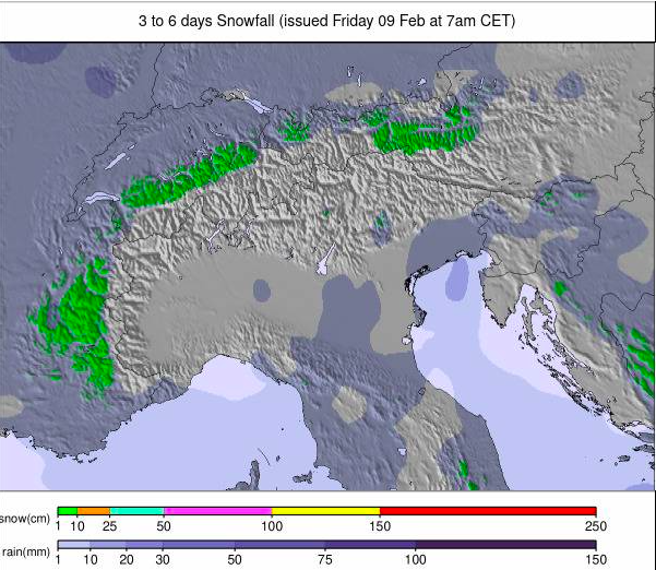
Image: European Alps snowfall forecast for the next 3-6 days.
ITALY REPORT
Conditions have improved a great deal across northern Italy, if not massive snowfalls temperatures have dropped and there has been some snowfall, most of it on higher slopes. Ever Mt Terminillo down near Rome, the story of it having little or no snow this winter picked up by Reuters and spread around the world last week, has seen some snow. It saw rain, again, at lower elevations though and that has been an issue at the big Italian resorts further north too, although temperatures have now dropped close to freezing even at lower altitudes. The big picture remains that most of Italy’s larger resorts remain fully open, or thereabouts. Cervinia (25/240cm / 10/96″) is posting the most terrain open still, nearly 300km (187 miles) thanks to its connection to Zermatt. The Milky Way (165/215cm / 66/86″) region with Sauze d’Oulx, Sestriere et al not far behind and Valle Gardena (45/80cm / 18/32”) the most in the Dolomites at 98% open – 185km/116 miles of piste.
ITALY FORECAST
It seems that the snowy conditions may be a little short-lived, but the picture for the week ahead is much more volatile with fast fluctuation temperatures, associated windy weather and many Italian areas seeing more snowfall towards the end of the week.
GERMANY REPORT
Germany continues to be a ski nation divided with the majority of its low-lying, smaller centres unable to open due to warm temperatures and lack of consistent snow cover, as has been the case across Europe. Of the 200 larger areas, just over 50 are open, and nearly 150 smaller, lower centres are closed. Of the open centres moist are fully open but some in lower-lying areas like the Black Forest and Central Uplands have battled to maintain snow cover on their higher runs but just have 10-25% of their potential areas open with thick cover.. Not great but better than nothing. The deepest snow is, as usual, up on the Zugspitze Glacier (120/240cm/48/96”), Germany’s highest slopes. But there’s about three times as much terrain open at Balderschwang (30/50cm / 12/20”) which despite fairly thin cover says 100% of its 41km (26 miles) of slopes are open.
GERMANY FORECAST
A mixture of sunny and snowy/sleety/rainy days depending a good deal on altitude, once again. There’s a big temperature range from +15C in low valleys later this week to -15C up on high slopes and that’s what makes the difference. Unfortunately, most German centres remain in the lower-lying category.
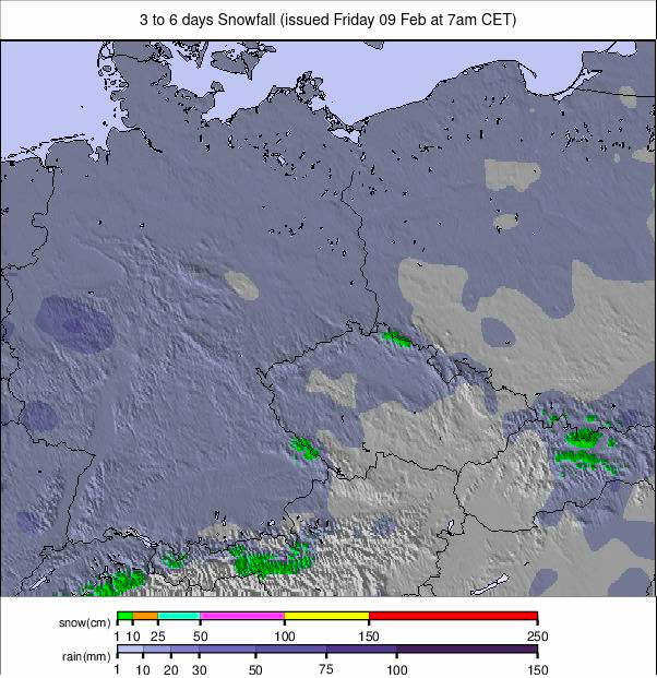
Image: Germany snowfall forecast for the next 3-6 days.
SCANDINAVIA REPORT
Scandi ski areas are still reaping the benefits of Storm Ingunn which blew in the weekend after last, boosting bases and bringing powder across the region. There’s been plenty more snowfall since as well. Most areas have 90% or more of their terrain open, including the largest, Sweden’s Åre (60/120cm / 24/48”) with more than 80km (50 miles) of trails skiable. Western Norway’s coastal Myrkdalen ( 130/200cm / 52 /80”) and neighbouring Voss ( 175/190cm / 70/76”) are posting the area’s thickest snowpack up top.
SCANDINAVIA FORECAST
Plenty of light-moderate snowfall across the region for the week ahead. Most days are snowy with temperatures in the -3 to -23C range through the 24-hour cycle. Just a 24-hour dry and sunny spell is forecast towards the end of the week before the snowfall resumes.
SCOTLAND REPORT
Scottish centres have finally enjoyed some fairly stable and quite cold weather after weeks of gales, yoyoing temperatures and at times torrential rain. They have not had a lot of fresh snow though so it has been a case of trying to manage and make the best of what’s there during what is a busy half-term week. Cairngorm announced its lift tickets for its limited nursery slopes area were sold out for half term before it even began. It, along with The Lecht, Glenshee and Glencoe have nursery areas maintained by all-weather snowmaking machines. It, Glencoe and Glenshee also had additional non-beginner terrain open, but severely limited and in some cases only suited to good skiers and hike-to in Cairngorm’s case. Nevis Range is currently the only centre not offering snowsports at the time of writing.
SCOTLAND FORECAST
Cool and dry for the rest of the week with snow, sleet or rain showers depending on altitude and time of day of the precipitation. Currently, winds are forecast to be light by Highland standards.
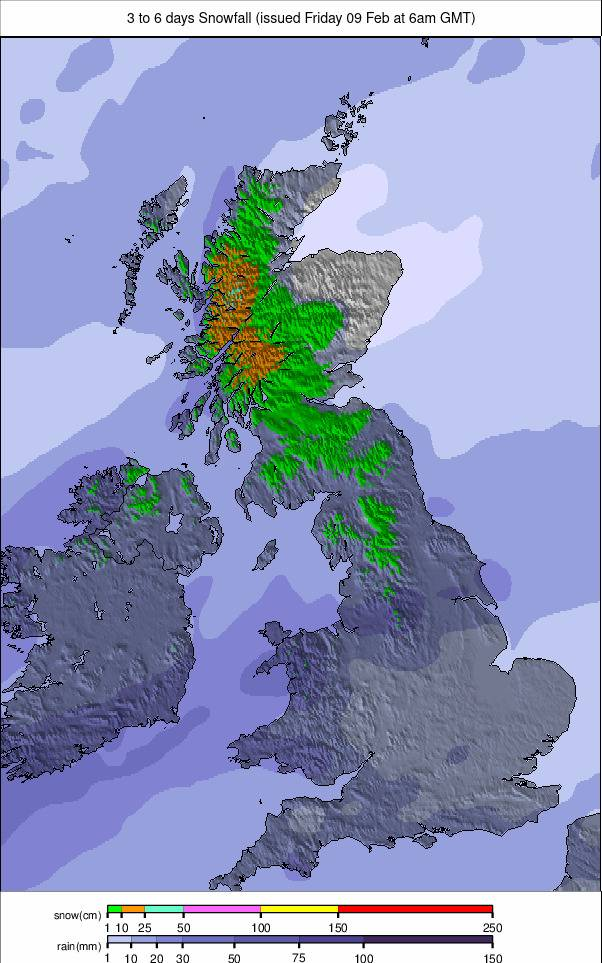
Image: UK and Northern Ireland snowfall forecast for the next 3 days.
SPAIN / ANDORRA REPORT
There’s much relief in Spain, Andorra and the French Pyrenees as temperatures finally drop and snow starts falling again after a month of mostly warm, dry weather with temperatures peaking as high as +22C in January …following the warmest December on records. But since the weekend we’ve seen temperatures back below freezing, on high slopes at least and 10-20cm (4-8”) snowfalls on higher slopes. It’s been getting colder slower in valleys and at the world Cupo races in Soldeu, Grandvalira, (25/60cm / 10.24″) in Andorra at the weekend a commentator described winter at the top of the mountain, spring at the bottom. So despite the snow things remain far from ideal in terms of open terrain, which remains limited and not dramatically increased, but still fresh snow on top of a hard-packed base makes for nice piste conditions again.
SPAIN / ANDORRA FORECAST
It seems the snowy conditions may be short-lived with sunshine now returning and temperatures climbing back to double figures in valleys and a few degrees above freezing on the highest slopes in the afternoons too. But we are expecting another dip and more snow next weekend so hopefully, things are at least more unsettled with the sunshine and warmth a little more fragmented.
BULGARIA / ROMANIA REPORT
Bulgaria’s Bansko (15/90cm / 6/36”) was in the ski world spotlight, alongside Andorra’s Soldeu, as the alpine skiing world cup tour rolled into the Pirin mountains having missed the previous weekend in Chamonix, France and Garmisch, Germany due to warm conditions. Alas on Sunday torrential rain led to Bansko joining those famous names with its second planned race, the slalom, cancelled. On the Saturday though a close-up examination of the GS racecourse highlighted how conditions have been for months in the mornings – hard and icy up top, springlike towards the base. They’ve returned to that after the rain and it remains the picture across the country and indeed across eastern and much of the rest of Europe.
BULGARIA / ROMANIA FORECAST
Cold and sunny for the next few days with temperatures in the -8 to _+2C range. Snowfall returning at the weekend if forecasts hold out.
CZECH REPUBLIC / SLOVAKIA REPORT
The Czech Republic has been hosting the Biathlon World Championships this week and unfortunately, this has been highlighting green slopes with strips of wet snow and heavy rain falling at Nové Město. The good news, or at least relief, though is that the stadium is very low, much closer to sea level than most ski areas in the region. Although… it also highlights the fact that smaller, lower centres in the region have had problems opening all season due to the conditions. This past week though has not been so bad with colder weather arriving at the weekend and snow showers up high. The Czech Republic’s largest centre, Špindlerův Mlýn (50/120cm / 20/48”) is fully open, as are most of the other destination resorts in the region.
CZECH REPUBLIC / SLOVAKIA FORECAST
Temperatures range between -5C on higher slopes overnight and +10C in valleys in the afternoons. Plenty of precipitation is forecast which will either be snow up high or rain depending on altitude and the time of day or night it arrives. Windy gusts are expected through the week too.
NORTH AMERICA
NORTH AMERICA INTRO
A much quieter week across North America following the big snowfalls in California and the Rockies a week ago. That said it has kept snowing in The Rockies with ski areas in Colorado and Utah posting several feet more snowfall this week, and powder conditions reported by ski areas in Arizona and New Mexico. The less good news is in the Pacific Northwest where the warm weather and dry (or wet)( conditions continue to challenge operations. So much so that one smaller area, Montana’s Teton Pass, announced it was giving up trying to reopen this winter and is now closed until next season. On the other hand, New Mexico’s Sandia Peak reopened for the first time in three seasons. Fairly good conditions in the East and Midwest, although there have been brief worrying warm spells again here too.
ROCKIES REPORT
A bit of a north/south divide and unusually for snow conditions, the north is faring worse than the south, or at least the northwest. On the one hand, after a stream of big snowfalls, ski areas in Arizona, New Mexico, Colorado and Utah as well as Jackson Hole up in Wyoming are all posting plenty of powder pics and in most cases are fully open with decent depths. But a little further west in Montana it’s a different story with one of North America’s biggest areas Big Sky (33/43” / 83/107cm) still struggling to open with less than half its terrain skiable, and smaller Teton Pass announcing at the weekend that it was essentially cutting its losses and closing for the rest of the season. Conversely, though conditions are the best they’ve been all season in much of The Rockies with America’s largest ski area at Park City (75/98″ / 187/244cm) posting good depths and 100% open. Sandia Peak in New Mexico has also opened for the first time in three years thanks to good conditions there.
ROCKIES FORECAST
Mostly sunny weather for the week ahead, daytime highs at resort level creeping up a few degrees above freezing, overnight lows up high down to springlike figures Fahrenheit.
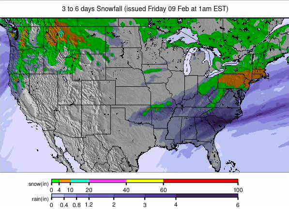
Image: USA summary overview snowfall forecast for the next 3-6 days.
USA WEST REPORT
The US West – at least more southerly states, particularly California and also parts of Oregon, continues to celebrate the big snowfalls of last week which brought over seven feet (2 metres) of snowfall to higher altitude ski slopes, transforming conditions. Mammoth Mountain (86/117″ / 215/294cm) is now posting one of the three deepest snowpacks in North America and its slopes are 90% open. Timberline (78/116″ / 195/290cm) in Oregon to the north also has some of the deepest snow, hopefully, good news for both for spring operations ahead. Meanwhile, Palisades Tahoe (41/96″ / 105/239cm) has the most terrain open in the West, its slopes are now 80% open.
USA WEST FORECAST
It’s a mostly dry forecast with temperatures in the low 20s to high 30s Fahrenheit range this week. There’s plenty of sunshine expected across the West too.
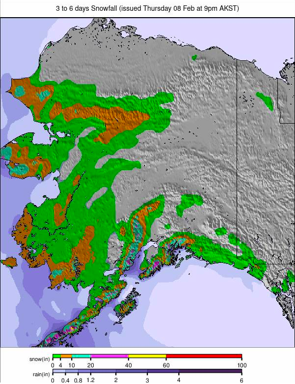
Image: Alaska snowfall report for the next 3-6 days.
MIDWEST REPORT
Another rather sub-par week for many parts of the Midwest with temperatures too warm for snowmaking and mostly dry weather. But some centres are managing better than others and most have at least some of their terrain open, with mostly machine-made snow. Michigan’s Ski Brule (48/48″ / 120/120cm) is one of those reporting its slopes 100% open and has the deepest reported snow depth in the Midwest too.
MIDWEST FORECAST
The forecast actually looks quite promising for the week ahead with temperatures largely staying below freezing and snow forecast towards the end of the week.
USA EAST REPORT
There have been mostly favourable conditions across the Eastern US with below-freezing temperatures all week and some light to moderate snowfalls giving slope cover refresh through the week between sunny days to enjoy it. In short, one of the best weeks of the season so far. Killington (8/16” / 20/40cm) is now up to 93% open, the most it has been all season while Maine’s Sunday River (28/32”) / 70/80cm) is up at 97%. It’s also posting the deepest snow in the Northeast although Snowshoe Mountain (18/46” / 45/114cm) down south in West Virginia is topping the table for the East as a whole
USA EAST FORECAST
It’s looking sunny for the week ahead with temperatures up to the high 30s and low 40s Fahrenheit in the afternoons, but dropping back below freezing overnight. Temperatures are dropping and snowfall is expected at the weekend.
CANADA
CANADA WEST REPORT
It’s been cool with snow showers for much of Alberta and BC this week, but Canadian media has been reporting on the battle being faced by West Coast ski areas like Cypress Mountain (0/100cm / 0/40”), Whistler Blackcomb (5/135cm / 2/54”) and Grouse Mountain (35/85cm / 14/34”) to open terrain in the face of warm, wet weather. Cyrpress and Grouse each have less than 10% of their terrain open and Whistler is having issues on lower runs but reports it is still 80% open, the most in North America. Despite challenging conditions at every one of its planned stops to date, and being forced to stage an impromptu first leg in Verbier instead, the Freeride World Tour is due to roll into Kicking Horse this week for the seventh time with competition planned for the challenging Ozone Face. Big White (70/176cm / 28/70”) has Canada’s deepest snow and is 99% open.
CANADA WEST FORECAST
Continuing with much of the same, mostly overcast skies with fronts expected to bring light to moderate snowfall (5-10cm / 2-4”) accumulations around Thursday and Saturday. Temperatures down top -10C overnight on high slopes., a little above freezing at resort level in the afternoons.
CANADA EAST REPORT
Eastern Canadian ski areas are enjoying the best conditions of the winter so far with consistently cold temperatures, fresh snowfall and most areas now fully open, some for the first time in the 23-24 season. Tremblant (0/130cm / 0/52”) has the deepest snow in the east and is 90% open.
Image: West Canada snowfall forecast for the next 3-6 days.
CANADA EAST FORECAST
Mostly sunny skies with some overcast days and very light snow showers. Temperatures are consistently below freezing at all levels, night and day.
ASIA
JAPAN REPORT
It’s been a snowy week in Japan and base depths are now getting up around the deepest in the world, as they usually are, but this year has not been one of the best. This week has though with snow in Tokyo extending out across the country with decent accumulations reported pretty much everywhere. A growing number of areas are up at around 3.5m (nearly 12 feet) on upper slopes now with Niseko (130/340cm / 52/126”) in the mix. There have been big snowfalls on Honshu as well as Hokkaido with Myoko’s Seki Onsen (100/280cm / 40/108”) reporting a 40cm/16”/24-hour accumulation on Saturday.
JAPAN FORECAST
Temperatures in the range of +3 to -13C through the coming week, and most Japanese ski areas will see regular snowfalls of between 5 and 25cm (2 and 10″) every 24 hours.
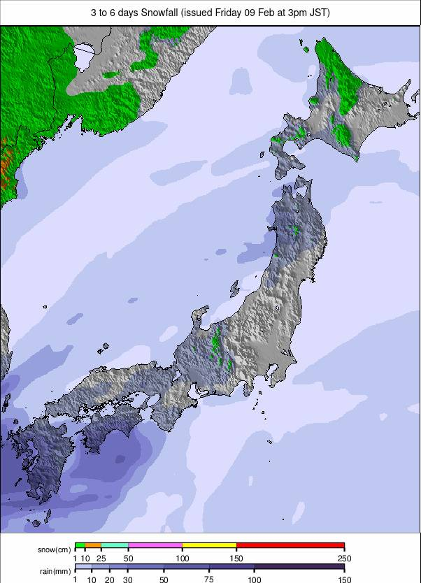
Image: Japan snowfall forecast for the next 3-6 days.


