El Niño Update: This Event Could Be Historic. Here's What It May Mean For Snow
As the Northern Hemisphere snow season approaches, the US National Oceanic and Atmospheric Administration (NOAA) has updated its outlook for the strengthening El Niño. Here we cut through the media hype and look at what the emerging patterns could mean for mountain snowfall this winter.
As the Northern Hemisphere snow season approaches, the US National Oceanic and Atmospheric Administration (NOAA) has updated its outlook for the strengthening El Niño in the Pacific. Here we cut through the media hype and look at what the emerging patterns could, though may not, mean for mountain snowfall this winter.
NOAA says El Niño is strengthening rapidly and gives it a greater than 90% chance of becoming very strong. It also estimates a 75% chance that its three-month RONI value, the strength measure used for this forecast, will exceed every previous El Niño in the record back to 1950. Sea surface temperatures in the eastern equatorial Pacific were already more than three degrees above normal in August, while the more widely quoted Niño-3.4 region sat at +1.8°C. This is widely reported as a 'Super El Niño', although that's a media-invented term, not one NOAA uses.
It's also important to note a few more points:
First: El Niño tilts the odds toward heavier precipitation in some areas, potentially good news for snowfall.
Second: It also tilts the odds toward milder weather in some areas, potentially bad news for snowfall.
Third: El Niño affects different parts of the Pacific rim very differently: some typically see heavier precipitation, others are actually drier than usual, and many areas aren't affected much at all. The same goes for temperatures.
Fourth: This El Niño could reach unprecedented strength in NOAA's post-1950 record, and the wider Pacific setup also differs from the other exceptionally strong events, so it may not behave quite like the ones we've seen before.
All of this means the places worth watching for snow are those where the odds lean toward both heavier precipitation and cooler temperatures. One caution before the maps: above-normal precipitation does not automatically mean above-normal snowfall. Whether it falls as snow or rain comes down to temperature and the track of individual storms, which a seasonal map can't tell you.
Here's NOAA's new outlook for the November to January period. NOAA expects the El Niño to keep strengthening through the end of 2026.
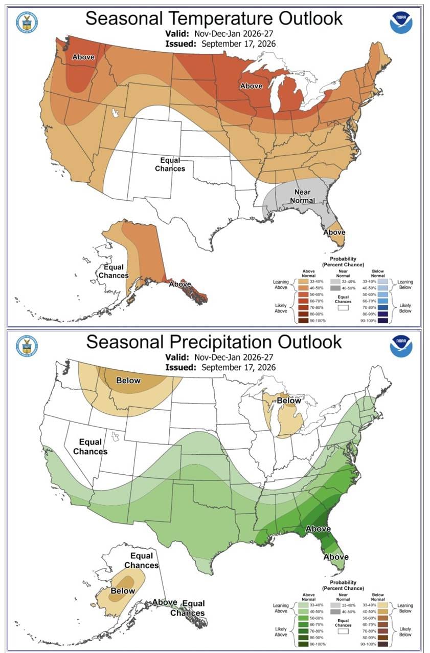
Fig. 1: NOAA Seasonal Outlook, Nov-Dec-Jan 2026-27, temperature (top) and precipitation (bottom). Issued 17 September 2026. Source: NOAA Climate Prediction Center. Colours show the probability of the season landing in the above- or below-normal third of the historical range, not how much rain or snow will fall.
The top map shows most of the country tilted mild this winter, particularly the northern states. The main exception is a broad 'Equal Chances' zone extending from parts of the Southwest and southern Rockies across the southern Plains, with a narrow Gulf Coast strip forecast closer to normal. 'Equal Chances' does not mean normal conditions are expected; it means NOAA cannot confidently favour above-, near- or below-normal temperatures. California and most areas farther north and east lean milder than average.
For precipitation, the strongest signal runs along the Gulf Coast and through the Southeast. There is also a weaker but meaningful tilt toward wetter-than-normal conditions from southern California through parts of Arizona, New Mexico and southern Colorado, which is where the southern Rockies come into the picture. Farther north, including much of Nevada and Utah, the signal is weaker or absent.
One side note: the highest precipitation probabilities are in Florida, but the southern Appalachians also sit in an above-normal precipitation zone. They may have enhanced precipitation chances, but temperatures and individual storm tracks will decide how much of it falls as snow, and a seasonal map can't resolve that.
NOAA also have an outlook for the latter half of winter.
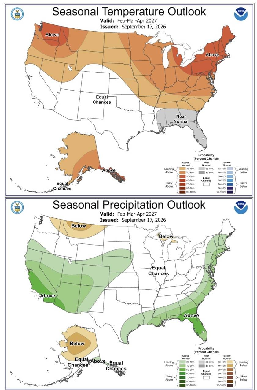
Fig. 2: NOAA Seasonal Outlook, Feb-Mar-Apr 2027, temperature (top) and precipitation (bottom). Issued 17 September 2026. Source: NOAA Climate Prediction Center. Colours show the probability of the season landing in the above- or below-normal third of the historical range, not how much rain or snow will fall.
By February to April, the wet signal becomes stronger across California and extends through parts of the Southwest and southern Rockies. Coastal California carries the highest western probabilities, while Nevada and Utah have a weaker signal. On temperature, the 'Equal Chances' zone now takes in most of California as well as the Southwest and southern Plains, so the picture there is genuinely open rather than tilted mild. The East Coast leans toward more precipitation but also milder than usual, so the question there is whether 'milder than usual' is still cold enough for snow.
Across the Pacific, the Japan Meteorological Agency (JMA) issued its cold-season outlook on 18 September. With El Niño continuing, it expects a warm winter nationwide and a weaker-than-usual winter pressure pattern. The Siberian High is forecast to be near normal strength, but the Aleutian Low that normally helps pull cold air across the Sea of Japan is expected to be weak, so classic northwesterly outbreaks are likely to be less persistent.
With high pressure favoured near the Philippines, warm and moist air is more likely to feed in from the south, and low-pressure systems are expected to have more influence on the Pacific side and across western Japan. As in North America, that can mean either heavier snowfall or more rain, depending on how cold it is when the systems arrive.
For the Sea of Japan side, home to the resorts that rely on those cold northwesterlies, JMA's outlook is for below-normal snowfall. The agency still advises preparing for snow as usual, since a mild average doesn't rule out individual heavy falls if a strong cold spell does break through.
For Europe, the connection is less direct, with Alpine winters governed mainly by North Atlantic and European circulation patterns rather than ENSO alone. ESA notes that El Niño can sometimes encourage atmospheric changes that weaken the polar vortex and alter the North Atlantic jet stream. That may tilt the odds of certain winter patterns, but it does not mean El Niño directly causes a cold or snowy European winter, and this is the least certain of all the outlooks above.
Further reading
ENSO Diagnostic Discussion, 10 September 2026 (NOAA Climate Prediction Center)
El Niño forms, expected to strengthen, say NOAA forecasters (NOAA)
Seasonal Forecasts (cold-season outlook, issued 18 September 2026) (Japan Meteorological Agency)
Pacific warming signals El Niño has stirred (European Space Agency)