


America’s Next Indoor Snow Centre Takes Shape
Construction of a new indoor snow centre for skiers, boarders and tubers appears to be making good progress at Heritage Farm in Wayne County, West Virginia.

Next 3 days weather summary:Heavy rain (total 28.0mm), heaviest during Mon afternoon. Warm (max 25°C on Wed morning, min 19°C on Tue night). Wind will be generally light. | Days 4-6 weather summary:Heavy rain (total 39.0mm), heaviest during Fri afternoon. Warm (max 24°C on Thu morning, min 16°C on Sat night). Wind will be generally light. | |||||||||||||||||
Monday 20 | Tuesday 21 | Wednesday 22 | Thursday 23 | Friday 24 | Saturday 25 | |||||||||||||
AM | PM | night | AM | PM | night | AM | PM | night | AM | PM | night | AM | PM | night | AM | PM | night | |
t-storm risk | t-storm risk | rain shwrs | t-storm risk | t-storm risk | rain shwrs | clear | t-storm risk | rain shwrs | rain shwrs | t-storm risk | rain shwrs | light rain | t-storm risk | rain shwrs | t-storm risk | t-storm risk | light rain | |
km/h | ||||||||||||||||||
Snow map | 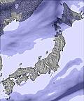 |  | 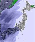 | 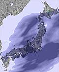 | 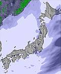 |  | ||||||||||||
— | — | — | — | — | — | — | — | — | — | — | — | — | — | — | — | — | — | |
mm | 3 | 7 | 1 | 4 | 8 | 1 | — | 3 | 1 | 1 | 5 | 1 | 3 | 11 | 7 | 3 | 4 | 4 |
max °C | 22 | 23 | 21 | 22 | 22 | 21 | 25 | 25 | 21 | 24 | 23 | 20 | 21 | 19 | 17 | 17 | 17 | 16 |
min °C | 21 | 21 | 20 | 21 | 22 | 19 | 22 | 22 | 19 | 21 | 21 | 18 | 20 | 18 | 17 | 17 | 17 | 16 |
chill °C | 21 | 21 | 20 | 21 | 22 | 19 | 22 | 22 | 19 | 21 | 21 | 18 | 20 | 18 | 17 | 17 | 17 | 16 |
Humid % | 82 | 76 | 83 | 80 | 76 | 79 | 73 | 57 | 84 | 76 | 68 | 89 | 82 | 88 | 96 | 94 | 97 | 97 |
Freeze m | 5400 | 5400 | 5450 | 5400 | 5350 | 5450 | 5450 | 5350 | 5300 | 5250 | 5150 | 5150 | 5150 | 5100 | 5000 | 5000 | 5050 | 5150 |
4:43 | — | — | 4:43 | — | — | 4:45 | — | — | 4:46 | — | — | 4:46 | — | — | 4:47 | — | — | |
— | 7:00 | — | — | 6:59 | — | — | 6:59 | — | — | 6:58 | — | — | 6:57 | — | — | 6:57 | — | |
Go pro and carve into:
Avalanche information: Japan Avalanche Network
Latest snow reports near Chateraise Ski Resort Yatsugatake:
| Top snow depth: | — |
|---|---|
| Bottom snow depth: | — |
| Fresh snowfall depth: | — |
| Last snowfall: | 7 Apr 2026 |
| Snow Alerts | Create Alert |
0.0 | Bluebird Powder days Fresh snow, mostly sunny, light wind. |
|---|---|
0.0 | Powder days Fresh snow, limited sun, any wind. |
0.0 | Bluebird days Average snow, mostly sunny, light wind. |
The above table gives the weather forecast for Chateraise Ski Resort Yatsugatake at the specific elevation of 1620 m. Our sophisticated weather models allow us to provide snow forecasts for the top, middle and bottom ski stations of Chateraise Ski Resort Yatsugatake. To access the weather forecasts for the other elevations, use the tab navigation above the table. For a wider view of the weather, check out the Weather Map of Japan.
Click here to read further information on freezing levels and how we forecast our temperatures.
Resort name is also written as Yatsugatake Sailer Valley.
Hello all people of Sailer Valley, I have been as ski instructor in Sailer Valley in 1989/1990 with Toni Sailer at the Opening Ceremony. My family and I want to help you, if some of you need help from Austria! Please write an E Mail to us, we will do all we can to help you! Regards from Austria Babsi I do not know, if there is somebody who remembers me, I have been there with Kondo family, they had 3 children, Mr. watanabe,... [Editor's note: this post will stay in place in order to generate a response]
Barbara Seiser-Pflug from Austria writes:
Hello all people of Sailer Valley,
I have been as ski instructor in Sailer Valley in 1989/1990 with Toni Sailer at the Opening Ceremony.
My family and I want to help you, if some of you need help from Austria!
Please write an E Mail to us, we will do all we can to help you!
Regards from Austria
Babsi
I do not know, if there is somebody who remembers me, I have been there with Kondo family, they had 3 children, Mr. watanabe,...
[Editor's note: this post will stay in place in order to generate a response]
Click here to submit your own review of Chateraise Ski Resort Yatsugatake


 Nearest