
Last snowfall:
Past 12 days
3.0 cm
Sep 24
1.0 cm
Sep 25
13 cm
Sep 26
4 cm
Sep 27
Resort report:
 |  Tell us Tell us |
|---|---|
 | |
 | 1.0 cm Wed 14 Oct (PM) |
 | 10 cm Thu 15 Oct (PM) |
 | |
 |
Snow Park snow conditions
- 0Bluebird Powder days
- 0Powder days
- 3Bluebird days
The Snow Park snow report is: out of 0 Lifts open. Our model predicted that 17cm (7 inches) of snow fell over 18 hours between Saturday 26 of September at 9PM and Sunday 27 of September at 4PM NZDT at the mid mountain level


| Upper snow depth: |  Tell us Tell us | |
|---|---|---|
| Lower snow depth: | ||
Our Snow Report for Snow Park brings daily updates on the snow conditions, snow depths, piste and offpiste conditions and the number of open ski lifts. The latest Snow Park snow report shown below was updated on 27 Sep 2026. Snow Reports are provided regularly throughout the ski season courtesy of our own network of ski resort managers and Skiresort Service International GmbH. In addition to the current report on ski conditions, we also provide webcams (including a 4 week cam archive), current live observations from nearby weather stations and also historical snow data for Snow Park.
| Tell us |
|---|---|
| |
| 1.0 cm Wed 14 Oct (PM) |
| 10 cm Thu 15 Oct (PM) |
| |
|


Latest snow reports near Snow Park:
0.3 | Bluebird Powder days Fresh snow, mostly sunny, light wind. |
|---|---|
0.4 | Powder days Fresh snow, limited sun, any wind. |
0.0 | Bluebird days Average snow, mostly sunny, light wind. |
Latest snow reports near Snow Park:
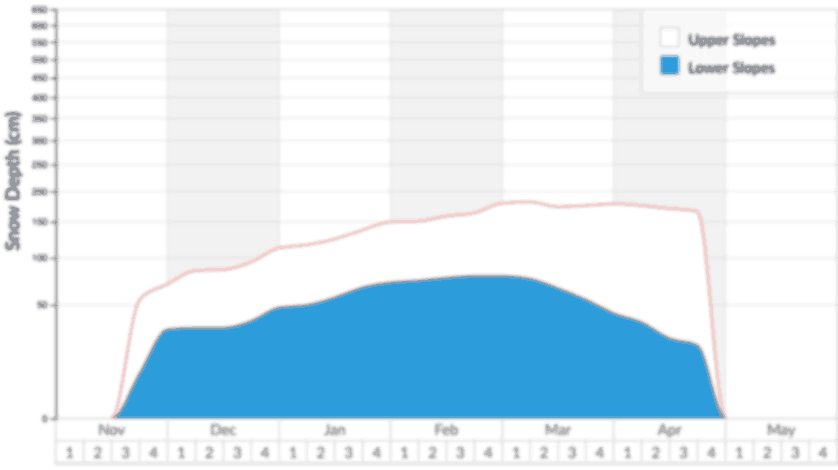
Recorded snow depths for the upper and lower slopes in Snow Park 2026. The long term average for the upper slopes is also shown for comparison.
Find the best conditions for skiing and snowboarding near Snow Park using our Snowfinder page.
Resort | Issued: yesterday 9 km away | Issued: yesterday 27 km away | Issued: yesterday 28 km away | Issued: yesterday 30 km away | Issued: 3 days ago 46 km away |
|---|---|---|---|---|---|
Webcam |  |  | | | |
Snow Depth | Upper Lower 105 cm 60 cm | Upper Lower 0 cm 0 cm | Upper Lower 160 cm 40 cm | Upper Lower 0 cm 0 cm | Upper Lower — — |
Piste | Spring snow | — | Spring snow | — | — |
Off Piste | — | — | — | — | — |
Piste State | |||||
Last Snow | Amount: Date: 4 cm 13 days ago | Amount: Date: 1.0 cm 8 days ago | Amount: Date: 1.0 cm 8 days ago | Amount: Date: 3.0 cm 8 days ago | Amount: Date: 1.0 cm 3 days ago |
Next 9 Days | 0-3 3-6 6-9 0.0 cm 11.0 cm 0.0 cm | 0-3 3-6 6-9 0.0 cm 8.0 cm 0.0 cm | 0-3 3-6 6-9 0.0 cm 14.0 cm 0.0 cm | 0-3 3-6 6-9 0.0 cm 11.0 cm 0.0 cm | 0-3 3-6 6-9 0.0 cm 14.0 cm 0.0 cm |
Weather | Sat  Sun Mon  Mid station 1594 m | Sat Sun Mon Mid station 1418 m | Sat Sun Mon Mid station 1756 m | Sat Sun Mon Mid station 1610 m | Sat Sun  Mon Mid station 1856 m |
The snow report describes the piste and off-piste ski conditions at Snow Park. You can submit an updated snow report here. Piste and off-piste are often different so we ask snow reporters to describe Snow Park piste and off-piste conditions separately. If these details are missing from the Snow Park snow report, you can predict off-piste conditions using the snow depth, the date of the most recent snowfall at Snow Park, the Snow Park weather report and the forecast.
Members can check the hindcast for a timeline of Snow Park weather conditions. This detailed weather log makes it easy to predict snow conditions at Snow Park, even when the snow report is too old to be useful. The hindcast shows when our weather model last predicted snowfall at Snow Park. It shows how much snow we think fell then, and the way freezing level, wind and weather have varied through time. You will be able to predict whether to expect off-piste powder, slush, spring snow, ice or wind crust.
If you see a report of powder or fresh snow conditions several days after snow last fell, there is usually a good reason. At crowded ski resorts, off-piste new snow will be tracked out within hours of a fresh fall but wherever crowds are light in relation to the accessible terrain, it will be possible to stay fresh much later, perhaps several days later. Alternatively, strong winds sometimes redistribute powder snow enough to cover old tracks, or it may simply be that the ski area was not fully open for some period after the snow fell, so fresh snow that fell a while ago has remained un-tracked until this report.
Whenever weather conditions change, Snow Park snow conditions will change too, so it is important to check the time and date of the Snow Park snow report and to guess what effect the weather will have had on snow quality between then and now. For example, the Snow Park snow report on Friday afternoon may indicate fresh powder but if Friday night is mild and rainy then ski conditions will be very poor on Saturday morning. Conversely, if the weather stays stable and cold, the same snow report can be valid for more than a week. We advise that you check the Snow Park snow forecast to see if conditions are likely to change before your visit.
Many skiers enjoy moguls and fast icy pistes but for off-piste skiers and free-ride snowboarders, fresh snow starts to deteriorate from the moment it settles. Wind, rain and periods of above-freezing temperature are the primary cause of the evolution from fresh powder to windslab, ice or slush. High altitude slopes that are shaded from the sun and sheltered from the wind preserve powder stashes longer after fresh snowfall. If the snow report mentions pockets of powder at Snow Park, study the Snow Park piste map in relation to the wind direction to determine the most likely locations.
We stress the importance of checking the date on the Snow Park snow report particularly around weekends. For example, the snow report for Snow Park on Friday may indicate powder after recent snowfall but following a sunny and busy weekend, when the locals hit the mountains en masse, the ski conditions (at any resort) can deteriorate rapidly and late arrivals may see very different ski conditions. Of course some people look for deteriorating conditions in the snow report for the likely development of mogul fields but for powder lovers and particularly snowboarders this can mean tracked out off-piste snow. Of course, this doesn’t always happen quickly after fresh snowfall particularly at quiet South facing resorts at high altitude where genuine powder stashes may be found days or even weeks later. It is worth checking the piste map for Snow Park (found in menu above) for the location of favourable slopes that may be described in the "Snow Park Snow Conditions" part of the snow report. In addition to checking the Snow Park snow report we recommend that you check the snow forecasts found in the menu at the top of the page along with our ski resort guide.




 Nearest