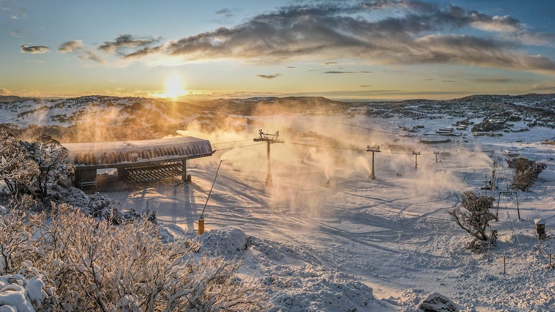
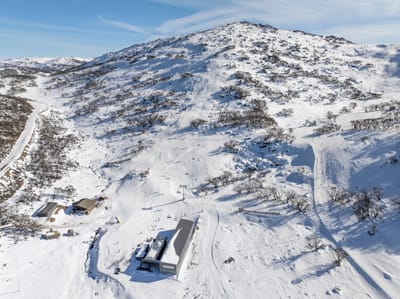
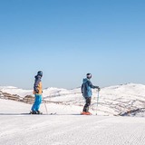
Perisher snow
Ski Australia - New South Wales

Perisher Snow Forecast

Weather Forecast for Perisher at 1867 m
Issued: 9 am  22 May 2025 (local time)

New snow in Perisher

22.0cm8in
Mon 26th (AM)
The snow forecast for Perisher is: Heavy rain (total 34.0mm), heaviest during Fri morning. Mild temperatures (max 6°C on Fri morning, min 2°C on Sat night). Winds increasing (light winds from the N on Fri afternoon, near gales from the WNW by Sat night).

Perisher Weather (Next 3 days): The snow forecast for Perisher is: Heavy rain (total 34.0mm), heaviest during Fri morning. Mild temperatures (max 6°C on Fri morning, min 2°C on Sat night). Winds increasing (light winds from the N on Fri afternoon, near gales from the WNW by Sat night).

Perisher Weather (Days 4-6): A heavy fall of snow, heaviest during Mon morning. Freeze-thaw conditions (max 4°C on Sun morning, min -5°C on Mon night). Winds decreasing (gales from the NW on Sun night, moderate winds from the SW by Tue night).


Perisher Live Weather

ResortSnow DepthTemp. (°C)Wind (km/h)Weather
Top Lift: 0.0m
4
15
cloud
Bottom Lift: 0.0m
6
10
cloud
Powered by Snow-Forecast.comSnow-Forecast.com
6 Day Forecast
Issued: 9 am 22 May 2025 / Updates in ::
Change Forecast Height
Choose Forecast
Last 6 daysScroll left for last 6 daysNow
Thursday
22
Friday
23
Saturday
24
Sunday
25
Monday
26
Tuesday
27
Wednesday
28
AM
PM
night
AM
PM
night
AM
PM
night
AM
PM
night
AM
PM
night
AM
PM
night
AM
PM
night
light rain
light rain
mod rain
mod rain
rain showers
light rain
rain showers
part cloud
clear
clear
clear
clear
mod snow
mod snow
snow showers
snow showers
snow showers
clear
part cloud
part cloud
clear
light rain
light rain
mod. rain
mod. rain
rain shwrs
light rain
rain shwrs
some clouds
clear
clear
clear
clear
mod. snow
mod. snow
snow shwrs
snow shwrs
snow shwrs
clear
some clouds
some clouds
clear
 km/h
15
E
15
ESE
25
E
20
ENE
10
N
25
WNW
30
WNW
30
WNW
45
WNW
55
WNW
55
WNW
75
NW
55
NW
50
WNW
55
W
45
WSW
35
SW
30
SW
15
SW
10
SSW
5
SSW
Snow map
 cm 
7
6
9
2.0
 mm 
1.0
5
10
10
3
4
1.0
max°C
5
5
5
6
5
4
3
3
2
4
4
3
-1
-3
-4
-2
-1
-1
0
0
1
min°C
4
4
5
5
4
3
3
3
2
3
3
1
-3
-4
-5
-5
-1
-1
0
0
0
chill°C 
1
0
1
1
1
-2
-2
-2
-5
-4
-4
-7
-12
-14
-15
-14
-8
-8
-5
-3
-2
Humid% 
91
98
98
96
83
84
89
71
52
44
37
48
83
96
96
88
71
74
79
82
72
Freezing level (m
2700
2650
2850
2800
2600
2700
2750
3150
2450
2350
2650
2350
1750
1400
1200
1100
1300
1400
1750
1900
2050
topliftbotliftSea lvl1000m2000m3000m4000m5000m
444543232331-4-5-6-4-1-2001655654332543-1-3-5-3-2-30-1-3
Sunrise
7:01
7:01
7:01
7:03
7:03
7:05
7:05
Sunset
5:04
5:02
5:02
5:01
5:01
5:00
5:00

Snow Radar

Latest snow reports near Perisher:

No recent snow reports

No recent snow reports

Perisher Snow Conditions

Top snow depth:0cm
Bottom snow depth:0cm
Fresh snowfall depth:
Last snowfall:18 May 2025
Snow AlertsCreate Alert
Other resorts in Australia - New South Wales are reporting: powder (0) / good piste (0)

Snow-Forecast Partner Offers

Snow History

Week 4 of May has on average:
0.1
Bluebird Powder days
Fresh snow, mostly sunny, light wind.
0.1
Powder days
Fresh snow, limited sun, any wind.
0.2
Bluebird days
Average snow, mostly sunny, light wind.

Perisher Resort Webcam

Live Snow webcam for Perisher
Most recent Perisher webcam image
Webcam courtesy of Perisher Blue website
  • todayPerisher webcam at lunchtime today
  • 2pm yesterdayPerisher webcam at 2pm yesterday
  • 2 days agoPerisher webcam 2 days ago
  • 3 days agoPerisher webcam 3 days ago
  • 4 days agoPerisher webcam 4 days ago