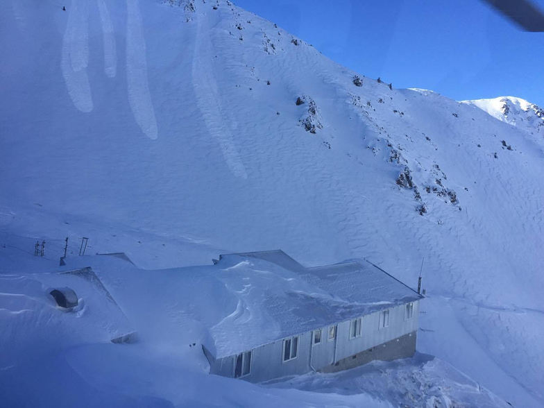


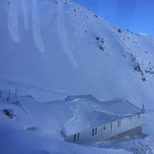
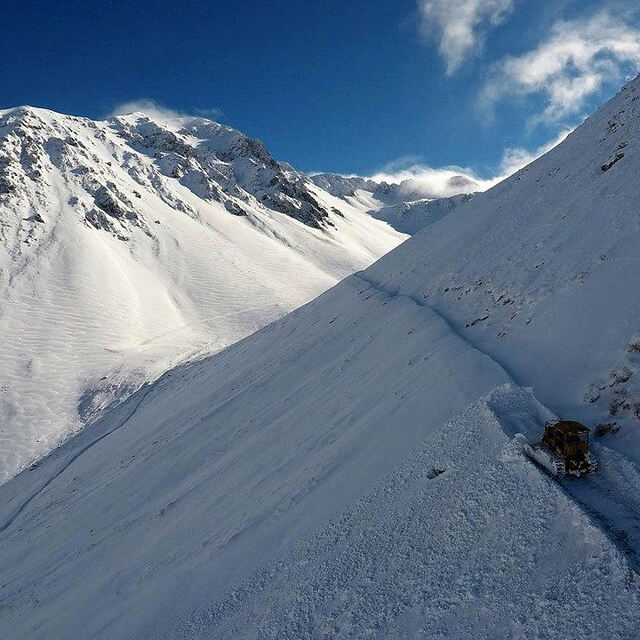
Portillo Storm Snowfall Total Passes 5m / 17 Feet
A snow storm that has now continued for nine days has taken Chilean ski resort Portillo to a snowfall total of 5.2 metres (17 feet) so far, with more snow forecast.

Next 3 days weather summary:A moderate fall of snow, heaviest on Thu night. Temperatures will be below freezing (max 0°C on Thu afternoon, min -11°C on Fri night). Winds decreasing (gales from the NW on Thu afternoon, light winds from the W by Sun morning). | Days 4-6 weather summary:Mostly dry. Temperatures will be below freezing (max -1°C on Mon morning, min -7°C on Tue night). Winds decreasing (near gales from the W on Mon morning, calm by Tue night). | ||||||||||||||||
Thu 30 | Friday 31 | Saturday 1 | Sunday 2 | Monday 3 | Tuesday 4 | ||||||||||||
PM | night | AM | PM | night | AM | PM | night | AM | PM | night | AM | PM | night | AM | PM | night | |
light snow | snow shwrs | snow shwrs | snow shwrs | snow shwrs | clear | clear | some clouds | clear | clear | snow shwrs | light snow | some clouds | some clouds | clear | clear | clear | |
km/h | |||||||||||||||||
Snow map |  |  |  |  |  |  | |||||||||||
3 | 5 | — | — | 3 | — | — | — | — | — | — | — | — | — | — | — | — | |
mm | — | — | — | — | — | — | — | — | — | — | — | — | — | — | — | — | — |
max °C | 0 | -2 | -5 | -6 | -9 | -7 | -5 | -2 | -2 | -2 | -2 | -1 | -2 | -4 | -5 | -5 | -6 |
min °C | -1 | -5 | -6 | -8 | -11 | -8 | -6 | -5 | -2 | -2 | -2 | -2 | -4 | -5 | -5 | -6 | -7 |
chill °C | -11 | -16 | -17 | -17 | -22 | -16 | -12 | -11 | -6 | -7 | -8 | -11 | -11 | -11 | -10 | -13 | -12 |
Humid % | 76 | 76 | 61 | 60 | 94 | 51 | 57 | 57 | 38 | 62 | 59 | 62 | 62 | 49 | 56 | 57 | 59 |
Freeze m | 2000 | 1450 | 1200 | 1250 | 550 | 450 | 950 | 1600 | 1800 | 1350 | 1250 | 1800 | 1800 | 1450 | 1050 | 1300 | 800 |
— | — | 7:48 | — | — | 7:47 | — | — | 7:45 | — | — | 7:43 | — | — | 7:43 | — | — | |
5:30 | — | — | 5:31 | — | — | 5:32 | — | — | 5:34 | — | — | 5:35 | — | — | 5:36 | — | |
Go pro and carve into:
Avalanche information: New Zealand Avalanche Advisory
Latest snow reports near Mount Olympus:
Recent moderate rain reported from Arthur's Pass National Park Visitor Centre at 737 metres elevation only 3 kms S of Temple Basin but it is forecast cold enough for snow at the ski area from Temple Basin
Recent heavy rain reported from Arthur's Pass National Park Visitor Centre at 737 metres elevation only 3 kms S of Temple Basin but it is forecast cold enough for snow at the ski area from Temple Basin
| Top snow depth: | — |
|---|---|
| Bottom snow depth: | — |
| Fresh snowfall depth: | — |
| Last snowfall: | 25 Jul 2026 |
| Snow Alerts | Create Alert |
1.2 | Bluebird Powder days Fresh snow, mostly sunny, light wind. |
|---|---|
1.0 | Powder days Fresh snow, limited sun, any wind. |
2.0 | Bluebird days Average snow, mostly sunny, light wind. |
The above table gives the weather forecast for Mount Olympus at the specific elevation of 2096 m. Our sophisticated weather models allow us to provide snow forecasts for the top, middle and bottom ski stations of Mount Olympus. To access the weather forecasts for the other elevations, use the tab navigation above the table. For a wider view of the weather, check out the Weather Map of New Zealand.
Click here to read further information on freezing levels and how we forecast our temperatures.
Overall 3.7 Based on 7 votes and 3 reviews
Rudeness in New Zealand is not something I have ever experienced in 12 seasons working at various areas around the place, so it was a surprise to experience it here, and from an employee too. It was my partner's first time on a nutcracker and the patroller, who shall remain nameless but didn't have a Kiwi accent, refused to help when I asked and told her she shouldn't be there if she can't ride a lift. She's a tough girl, climbed and ski toured on 6 continents and everyone struggles at first with these things. Anyway, we left pretty quick and went to Temple Basin, where everyone was super fun and the skiing was great. I'm sure Mt Olympus is awesome too and no doubt they've sacked Mr Grumpy by now. If not they should have.
kikapu from Canada writes:
Rudeness in New Zealand is not something I have ever experienced in 12 seasons working at various areas around the place, so it was a surprise to experience it here, and from an employee too.
It was my partner's first time on a nutcracker and the patroller, who shall remain nameless but didn't have a Kiwi accent, refused to help when I asked and told her she shouldn't be there if she can't ride a lift. She's a tough girl, climbed and ski toured on 6 continents and everyone struggles at first with these things.
Anyway, we left pretty quick and went to Temple Basin, where everyone was super fun and the skiing was great. I'm sure Mt Olympus is awesome too and no doubt they've sacked Mr Grumpy by now. If not they should have.


 Nearest