


America’s Next Indoor Snow Centre Takes Shape
Construction of a new indoor snow centre for skiers, boarders and tubers appears to be making good progress at Heritage Farm in Wayne County, West Virginia.

Next 3 days weather summary:Light rain (total 3.0mm), mostly falling on Wed afternoon. Warm (max 22°C on Thu afternoon, min 15°C on Tue night). Wind will be generally light. | Days 4-6 weather summary:Light rain (total 4.0mm), mostly falling on Sat afternoon. Warm (max 23°C on Fri afternoon, min 8°C on Sat night). Wind will be generally light. | |||||||||||||||||
Tuesday 21 | Wednesday 22 | Thursday 23 | Friday 24 | Saturday 25 | Sunday 26 | |||||||||||||
AM | PM | night | AM | PM | night | AM | PM | night | AM | PM | night | AM | PM | night | AM | PM | night | |
clear | clear | clear | clear | rain shwrs | rain shwrs | clear | clear | clear | clear | some clouds | clear | clear | t-storm risk | rain shwrs | clear | clear | some clouds | |
km/h | ||||||||||||||||||
Snow map |  |  | 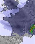 |  | 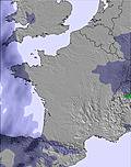 | 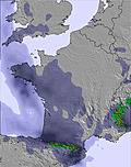 | ||||||||||||
— | — | — | — | — | — | — | — | — | — | — | — | — | — | — | — | — | — | |
mm | — | — | — | — | 1 | 2 | — | — | — | — | — | — | — | 1 | 3 | — | — | — |
max °C | 17 | 19 | 18 | 18 | 20 | 19 | 20 | 22 | 20 | 21 | 23 | 22 | 16 | 16 | 12 | 11 | 14 | 13 |
min °C | 16 | 19 | 15 | 16 | 20 | 17 | 18 | 21 | 17 | 17 | 22 | 17 | 15 | 14 | 8 | 8 | 13 | 10 |
chill °C | 15 | 19 | 14 | 15 | 20 | 17 | 18 | 21 | 16 | 16 | 22 | 16 | 14 | 14 | 5 | 5 | 11 | 8 |
Humid % | 46 | 42 | 40 | 34 | 35 | 38 | 31 | 28 | 29 | 25 | 26 | 34 | 52 | 66 | 82 | 61 | 43 | 86 |
Freeze m | 4550 | 4650 | 4650 | 4650 | 4750 | 4750 | 4650 | 4700 | 4800 | 4800 | 4850 | 4800 | 4400 | 3950 | 3450 | 3750 | 4200 | 4200 |
6:31 | — | — | 6:31 | — | — | 6:33 | — | — | 6:33 | — | — | 6:35 | — | — | 6:35 | — | — | |
— | — | 9:23 | — | — | 9:22 | — | — | 9:22 | — | — | 9:21 | — | — | 9:20 | — | — | 9:19 | |
Go pro and carve into:
Avalanche information: European Avalanche Warning Services (EAWS)
Latest snow reports near Mijanes-Donezan:
| Top snow depth: | — |
|---|---|
| Bottom snow depth: | — |
| Fresh snowfall depth: | — |
| Last snowfall: | 15 May 2026 |
| Snow Alerts | Create Alert |
0.0 | Bluebird Powder days Fresh snow, mostly sunny, light wind. |
|---|---|
0.0 | Powder days Fresh snow, limited sun, any wind. |
0.0 | Bluebird days Average snow, mostly sunny, light wind. |
The above table gives the weather forecast for Mijanes-Donezan at the specific elevation of 2001 m. Our sophisticated weather models allow us to provide snow forecasts for the top, middle and bottom ski stations of Mijanes-Donezan. To access the weather forecasts for the other elevations, use the tab navigation above the table. For a wider view of the weather, check out the Weather Map of France.
Click here to read further information on freezing levels and how we forecast our temperatures.
Overall 3.4 Based on 3 votes and 2 reviews
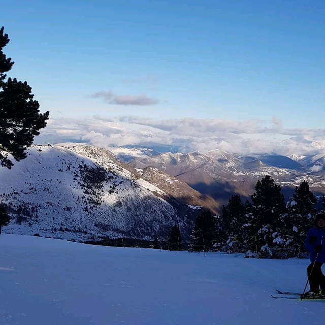
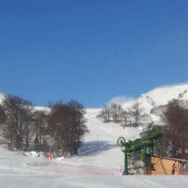
Mijanes is a fantastic small family ski resort in the beautiful canton of Donezan. The height of the resort means that it can suffer from lack of snow - but when it does snow, you're in for a treat. I am no expert but have been skiing for over twenty years and prefer this resort to anywhere else I have visited, as do the kids. Polite, caring, quiet, compact and cheap, it is a resort the French want to keep to themselves, although the area does attract some Spanish from over the boarder. Imagine a tree clad mountainside with all facilities within 100m of the lifts, lift attendants who make the kids wear their glasses, equipment hirers who remember your favourite boots, and dearest lift pass costing 15 Euros per day. Bring on the winter! Bring on the Vin Chaud!
peter wareing from United Kingdom writes:
Mijanes is a fantastic small family ski resort in the beautiful canton of Donezan. The height of the resort means that it can suffer from lack of snow - but when it does snow, you're in for a treat. I am no expert but have been skiing for over twenty years and prefer this resort to anywhere else I have visited, as do the kids. Polite, caring, quiet, compact and cheap, it is a resort the French want to keep to themselves, although the area does attract some Spanish from over the boarder. Imagine a tree clad mountainside with all facilities within 100m of the lifts, lift attendants who make the kids wear their glasses, equipment hirers who remember your favourite boots, and dearest lift pass costing 15 Euros per day. Bring on the winter! Bring on the Vin Chaud!


 Nearest