


Global Weekly Snow Roundup #320
Weekly Snow News for the world, updated 25 June 2026: Chile and New Zealand's seasons proper set to begin, Tignes and Sunshine reopen for summer skiing. weekend as Riksgransen ends its 2026 season.

Next 3 days weather summary:Light rain (total 2.0mm), mostly falling on Sun morning. Very mild (max 18°C on Sat afternoon, min 8°C on Sun night). Winds decreasing (strong winds from the SSW on Sat afternoon, light winds from the SW by Mon night). | Days 4-6 weather summary:Moderate rain (total 16.0mm), heaviest on Wed afternoon. Very mild (max 14°C on Wed morning, min 7°C on Thu night). Winds increasing (calm on Wed morning, fresh winds from the NW by Thu afternoon). | ||||||||||||||||
Sat 27 | Sunday 28 | Monday 29 | Tuesday 30 | Wednesday 1 | Thursday 2 | ||||||||||||
PM | night | AM | PM | night | AM | PM | night | AM | PM | night | AM | PM | night | AM | PM | night | |
clear | some clouds | rain shwrs | clear | some clouds | some clouds | some clouds | cloudy | cloudy | light rain | rain shwrs | light rain | light rain | light rain | light rain | rain shwrs | some clouds | |
km/h | |||||||||||||||||
Snow map | 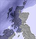 | 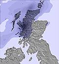 | 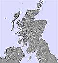 | 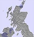 | 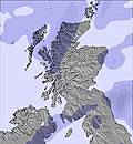 | 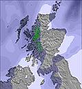 | |||||||||||
— | — | — | — | — | — | — | — | — | — | — | — | — | — | — | — | — | |
mm | — | — | 2 | — | — | — | — | — | — | 2 | 1 | 2 | 4 | 2 | 2 | 3 | — |
max °C | 18 | 15 | 13 | 12 | 9 | 14 | 14 | 11 | 14 | 12 | 11 | 14 | 14 | 11 | 11 | 13 | 8 |
min °C | 17 | 12 | 12 | 11 | 8 | 12 | 13 | 9 | 13 | 12 | 10 | 12 | 13 | 10 | 11 | 12 | 7 |
chill °C | 15 | 9 | 9 | 8 | 4 | 10 | 12 | 7 | 11 | 11 | 10 | 12 | 12 | 8 | 8 | 9 | 3 |
Humid % | 68 | 83 | 94 | 70 | 88 | 68 | 73 | 76 | 70 | 86 | 93 | 87 | 83 | 95 | 98 | 85 | 91 |
Freeze m | 3450 | 3400 | 3300 | 3100 | 2750 | 2750 | 2650 | 2400 | 2450 | 2600 | 2700 | 2950 | 2800 | 3400 | 2900 | 2650 | 2250 |
— | — | 4:33 | — | — | 4:33 | — | — | 4:35 | — | — | 4:35 | — | — | 4:37 | — | — | |
9:50 | — | — | 9:50 | — | — | 9:49 | — | — | 9:49 | — | — | 9:49 | — | — | 9:47 | — | |
Go pro and carve into:
Avalanche information: European Avalanche Warning Services (EAWS)
Latest snow reports near Harwood Common:
| Top snow depth: | — |
|---|---|
| Bottom snow depth: | — |
| Fresh snowfall depth: | — |
| Last snowfall: | 12 May 2026 |
| Snow Alerts | Create Alert |
0.0 | Bluebird Powder days Fresh snow, mostly sunny, light wind. |
|---|---|
0.0 | Powder days Fresh snow, limited sun, any wind. |
0.0 | Bluebird days Average snow, mostly sunny, light wind. |
The above table gives the weather forecast for Harwood Common at the specific elevation of 607 m. Our sophisticated weather models allow us to provide snow forecasts for the top, middle and bottom ski stations of Harwood Common. To access the weather forecasts for the other elevations, use the tab navigation above the table. For a wider view of the weather, check out the Weather Map of United Kingdom.
Click here to read further information on freezing levels and how we forecast our temperatures.
Overall 2.6 Based on 1 vote and 5 reviews
There is an unofficial website for Harwood Common. It's details include the exact grid location and a contact telephone number. You can find this on the 'landing page' for Harwood Common at www.snow-forecast.com
Hugh Everett (Wilmslow, UK) from United Kingdom writes:
There is an unofficial website for Harwood Common. It's details include the exact grid location and a contact telephone number. You can find this on the 'landing page' for Harwood Common at www.snow-forecast.com


 Nearest