


Portillo Re-Opens To Guests Arriving By Helicopter
Chile’s famous Portillo ski resort is reported to have re-opened to guests arriving by helicopter after being cut off by road for more than two weeks by over 6m/20 feet of snowfall.

Next 4 days weather summary:A dusting of new snow. Temperatures will be below freezing (max 0°C on Wed afternoon, min -2°C on Mon night). Wind will be generally light. | Days 5-7 weather summary:A heavy fall of snow, heaviest during Sun afternoon. Freeze-thaw conditions (max 3°C on Fri afternoon, min -2°C on Sun afternoon). Winds increasing (calm on Fri afternoon, strong winds from the NNW by Sat night). | |||||||||||||||
Tuesday 4 | Wednesday 5 | Thursday 6 | Friday 7 | Saturday 8 | ||||||||||||
night | AM | PM | night | AM | PM | night | AM | PM | night | AM | PM | night | AM | PM | night | |
light snow | snow shwrs | light snow | light snow | light snow | light snow | cloudy | cloudy | cloudy | some clouds | clear | clear | clear | some clouds | cloudy | light snow | |
km/h | ||||||||||||||||
Snow map | 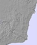 |  | 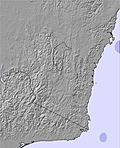 | 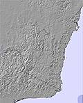 | 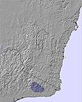 | 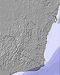 | ||||||||||
1 | — | 1 | 1 | 1 | — | — | — | — | — | — | — | — | — | — | 2 | |
mm | — | — | — | — | — | — | — | — | — | — | — | — | — | — | — | — |
max °C | -1 | -1 | -1 | -1 | -1 | 0 | -1 | 0 | 0 | 0 | 2 | 3 | 2 | 3 | 3 | 2 |
min °C | -2 | -2 | -2 | -2 | -1 | -1 | -2 | -1 | 0 | -1 | 0 | 3 | 1 | 2 | 2 | 0 |
chill °C | -8 | -8 | -7 | -7 | -6 | -5 | -7 | -6 | -4 | -7 | -3 | 1 | -3 | -1 | -3 | -7 |
Humid % | 95 | 83 | 92 | 96 | 99 | 96 | 94 | 89 | 89 | 93 | 85 | 67 | 76 | 76 | 77 | 89 |
Freeze m | 1450 | 1200 | 1350 | 1300 | 1400 | 1450 | 1300 | 1350 | 1500 | 1450 | 1500 | 2200 | 2050 | 2250 | 2500 | 2250 |
— | 7:07 | — | — | 7:05 | — | — | 7:05 | — | — | 7:03 | — | — | 7:03 | — | — | |
— | — | 5:27 | — | — | 5:28 | — | — | 5:28 | — | — | 5:29 | — | — | 5:30 | — | |
Go pro and carve into:
Avalanche information: Mountain Safety Collective
Latest snow reports near Dinner Plain:
| Top snow depth: | — |
|---|---|
| Bottom snow depth: | — |
| Fresh snowfall depth: | — |
| Last snowfall: | 29 Jul 2026 |
| Snow Alerts | Create Alert |
0.1 | Bluebird Powder days Fresh snow, mostly sunny, light wind. |
|---|---|
1.0 | Powder days Fresh snow, limited sun, any wind. |
0.1 | Bluebird days Average snow, mostly sunny, light wind. |
The above table gives the weather forecast for Dinner Plain at the specific elevation of 1521 m. Our sophisticated weather models allow us to provide snow forecasts for the top, middle and bottom ski stations of Dinner Plain. To access the weather forecasts for the other elevations, use the tab navigation above the table. For a wider view of the weather, check out the Weather Map of Australia.
Click here to read further information on freezing levels and how we forecast our temperatures.
Overall 4.5 Based on 3 votes and 1 review
First time skiing, the girls operating the poma lift made my experience a good one. Friendly and helpful, will visit again.
Deb from Australia writes:
First time skiing, the girls operating the poma lift made my experience a good one.
Friendly and helpful, will visit again.


 Nearest