


Portillo Storm Snowfall Total Passes 5m / 17 Feet
A snow storm that has now continued for nine days has taken Chilean ski resort Portillo to a snowfall total of 5.2 metres (17 feet) so far, with more snow forecast.

Next 4 days weather summary:A light covering of new snow, mostly falling on Tue night. Freeze-thaw conditions (max 2°C on Fri morning, min -4°C on Tue night). Winds decreasing (strong winds from the NW on Tue night, calm by Fri morning). | Days 5-7 weather summary:A dusting of new snow. Freeze-thaw conditions (max 3°C on Sat morning, min -4°C on Sun night). Winds increasing (calm on Fri night, near gales from the NW by Sun afternoon). | |||||||||||||||
Wednesday 29 | Thursday 30 | Friday 31 | Saturday 1 | Sunday 2 | ||||||||||||
night | AM | PM | night | AM | PM | night | AM | PM | night | AM | PM | night | AM | PM | night | |
light snow | light snow | light snow | snow shwrs | cloudy | snow shwrs | some clouds | some clouds | some clouds | clear | clear | clear | some clouds | clear | some clouds | light snow | |
km/h | ||||||||||||||||
Snow map | 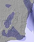 | 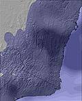 | 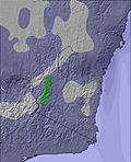 | 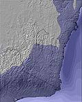 |  |  | ||||||||||
5 | 1 | 1 | — | — | — | — | — | — | — | — | — | — | — | — | 2 | |
mm | — | — | — | — | — | — | — | — | — | — | — | — | — | — | — | — |
max °C | 0 | -2 | -2 | -3 | -1 | 0 | -2 | 2 | 2 | -2 | 3 | 3 | 1 | 2 | 1 | -1 |
min °C | -4 | -2 | -2 | -4 | -1 | -3 | -4 | 0 | 0 | -2 | 2 | -1 | -1 | 1 | 0 | -4 |
chill °C | -12 | -9 | -6 | -8 | -1 | -3 | -7 | -2 | -2 | -2 | -2 | -6 | -7 | -6 | -8 | -11 |
Humid % | 96 | 93 | 98 | 78 | 83 | 89 | 93 | 93 | 75 | 72 | 80 | 75 | 87 | 83 | 80 | 95 |
Freeze m | 1500 | 1100 | 1250 | 1000 | 1250 | 1500 | 1350 | 1500 | 1900 | 2000 | 1900 | 2050 | 2000 | 1800 | 1750 | 1250 |
— | 7:11 | — | — | 7:11 | — | — | 7:11 | — | — | 7:09 | — | — | 7:09 | — | — | |
— | — | 5:22 | — | — | 5:22 | — | — | 5:23 | — | — | 5:23 | — | — | 5:24 | — | |
Go pro and carve into:
Avalanche information: Mountain Safety Collective
Latest snow reports near Dinner Plain:
Raining moderately in Falls Creek. Very windy today. Freeze-thaw conditions. No new snow. Some lifts are open. On piste snow is in wet condition. Off piste there is not enough snow for skiing. from Falls Creek
For Falls Creek: Strong winds. Temperatures are around freezing. There is a dusting of fresh snow. The majority of lifts are open. Snow conditions on piste are good. Not enough snow off-piste. from Falls Creek
| Top snow depth: | — |
|---|---|
| Bottom snow depth: | — |
| Fresh snowfall depth: | — |
| Last snowfall: | 12 Jul 2026 |
| Snow Alerts | Create Alert |
0.2 | Bluebird Powder days Fresh snow, mostly sunny, light wind. |
|---|---|
0.7 | Powder days Fresh snow, limited sun, any wind. |
0.0 | Bluebird days Average snow, mostly sunny, light wind. |
The above table gives the weather forecast for Dinner Plain at the specific elevation of 1506 m. Our sophisticated weather models allow us to provide snow forecasts for the top, middle and bottom ski stations of Dinner Plain. To access the weather forecasts for the other elevations, use the tab navigation above the table. For a wider view of the weather, check out the Weather Map of Australia.
Click here to read further information on freezing levels and how we forecast our temperatures.
Overall 4.5 Based on 3 votes and 1 review
First time skiing, the girls operating the poma lift made my experience a good one. Friendly and helpful, will visit again.
Deb from Australia writes:
First time skiing, the girls operating the poma lift made my experience a good one.
Friendly and helpful, will visit again.


 Nearest