


America’s Next Indoor Snow Centre Takes Shape
Construction of a new indoor snow centre for skiers, boarders and tubers appears to be making good progress at Heritage Farm in Wayne County, West Virginia.

Next 3 days weather summary:Light rain (total 5.0mm), mostly falling on Tue morning. Warm (max 20°C on Tue afternoon, min 9°C on Tue night). Wind will be generally light. | Days 4-6 weather summary:Heavy rain (total 48.0mm), heaviest during Sat night. Warm (max 26°C on Sat afternoon, min 11°C on Sat night). Wind will be generally light. | |||||||||||||||||
Tuesday 21 | Wednesday 22 | Thursday 23 | Friday 24 | Saturday 25 | Sunday 26 | |||||||||||||
AM | PM | night | AM | PM | night | AM | PM | night | AM | PM | night | AM | PM | night | AM | PM | night | |
t-storm risk | rain shwrs | clear | clear | clear | some clouds | cloudy | clear | clear | clear | clear | clear | rain shwrs | t-storm risk | heavy rain | t-storm risk | mod. rain | mod. rain | |
km/h | ||||||||||||||||||
Snow map |  |  |  |  |  |  | ||||||||||||
— | — | — | — | — | — | — | — | — | — | — | — | — | — | — | — | — | — | |
mm | 3 | 2 | — | — | — | — | — | — | — | — | — | — | 1 | 1 | 30 | 2 | 7 | 7 |
max °C | 17 | 20 | 16 | 17 | 20 | 17 | 18 | 20 | 17 | 19 | 22 | 19 | 24 | 26 | 16 | 15 | 16 | 12 |
min °C | 12 | 19 | 9 | 12 | 20 | 11 | 14 | 20 | 10 | 13 | 22 | 13 | 16 | 23 | 11 | 13 | 16 | 11 |
chill °C | 12 | 19 | 9 | 12 | 20 | 11 | 14 | 20 | 10 | 13 | 22 | 13 | 16 | 23 | 11 | 13 | 16 | 10 |
Humid % | 68 | 38 | 65 | 49 | 31 | 51 | 48 | 35 | 56 | 42 | 32 | 43 | 32 | 41 | 85 | 74 | 67 | 94 |
Freeze m | 3600 | 3400 | 3650 | 3900 | 3950 | 3750 | 3600 | 3400 | 3950 | 4250 | 4150 | 4300 | 4250 | 4250 | 3600 | 3350 | 3400 | 3300 |
6:01 | — | — | 6:01 | — | — | 6:03 | — | — | 6:03 | — | — | 6:05 | — | — | 6:05 | — | — | |
— | — | 9:15 | — | — | 9:15 | — | — | 9:14 | — | — | 9:13 | — | — | 9:12 | — | — | 9:10 | |
Go pro and carve into:
Avalanche information: European Avalanche Warning Services (EAWS)
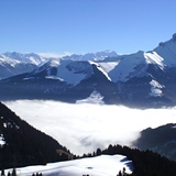
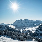
Latest snow reports near Chatel:
| Top snow depth: | — |
|---|---|
| Bottom snow depth: | — |
| Fresh snowfall depth: | — |
| Last snowfall: | 16 May 2026 |
| Snow Alerts | Create Alert |
0.0 | Bluebird Powder days Fresh snow, mostly sunny, light wind. |
|---|---|
0.0 | Powder days Fresh snow, limited sun, any wind. |
0.0 | Bluebird days Average snow, mostly sunny, light wind. |

The above table gives the weather forecast for Chatel at the specific elevation of 1201 m. Our sophisticated weather models allow us to provide snow forecasts for the top, middle and bottom ski stations of Chatel. To access the weather forecasts for the other elevations, use the tab navigation above the table. For a wider view of the weather, check out the Weather Map of France.
Click here to read further information on freezing levels and how we forecast our temperatures.
Overall 4.4 Based on 59 votes and 66 reviews
So many nice things to say about Chatel. I've been coming here for several weeks a season for 18 years and the skiing has always been very good. There's a piste for everyone and plenty of off-piste opportunities too. The village is typically alpine with only a few monstrosities in terms of apartment blocks. Lots of new developments have created pressure on infrastructure but only at very busy times. There are buses to the ski areas and around the village. If you must use the car then get out early to Pre la Joux during New year and February holidays. I have even driven up there first thing and come back to the village for breakfast before going skiing so the transport back to the village is not dependent upon very busy buses. If you go out at 10.30 and then don't complain there's insufficient parking! Compared to 3 Vallees and Tignes it is quaint and much, much cheaper. I was in Meribel last week and restaurant prices were 30% higher there. Lots of different nationalities make Chatel interesting and everyone is welcoming in the shops and cafes. I'd say keep an eye on the weather because even at 1200m you can get caught out with snow conditions. If you don't have winter tyres and chains you will look an idiot. I say this as it is dumping down today and the roads are treacherous.
Godfrey BLATCHER from United Kingdom writes:
So many nice things to say about Chatel. I've been coming here for several weeks a season for 18 years and the skiing has always been very good. There's a piste for everyone and plenty of off-piste opportunities too.
The village is typically alpine with only a few monstrosities in terms of apartment blocks. Lots of new developments have created pressure on infrastructure but only at very busy times. There are buses to the ski areas and around the village. If you must use the car then get out early to Pre la Joux during New year and February holidays. I have even driven up there first thing and come back to the village for breakfast before going skiing so the transport back to the village is not dependent upon very busy buses. If you go out at 10.30 and then don't complain there's insufficient parking!
Compared to 3 Vallees and Tignes it is quaint and much, much cheaper. I was in Meribel last week and restaurant prices were 30% higher there. Lots of different nationalities make Chatel interesting and everyone is welcoming in the shops and cafes.
I'd say keep an eye on the weather because even at 1200m you can get caught out with snow conditions. If you don't have winter tyres and chains you will look an idiot. I say this as it is dumping down today and the roads are treacherous.


 Nearest