
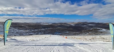
Afriski Turns 25
Lesotho’s Afriski, one of the world’s newest ski centres and possibly the only outdoor ski area still operational in Africa, is celebrating 25 years since opening.
By using Snow-Forecast, you agree to our Terms & Services.
Don't have an account? Join now
Alternatively, you can now use your Outside account to sign in to any brand in the Outside digital ecosystem, including Snow-Forecast, Surf-Forecast, and Mountain-Forecast.

Selkirk Powder Weather (Next 3 days): The snow forecast for Selkirk Powder is: Light rain (total 4.0mm), mostly falling on Mon night. Warm (max 28°C on Sun afternoon, min 7°C on Mon night). Winds increasing (calm on Sun morning, fresh winds from the NE by Mon night).
Selkirk Powder Weather (Days 4-6): Mostly dry. Warm (max 28°C on Fri afternoon, min 7°C on Tue night). Winds increasing (calm on Thu morning, fresh winds from the SW by Fri afternoon).
| Resort | Snow Depth | Temp. (°C) | Wind (km/h) | Weather | ||
|---|---|---|---|---|---|---|
| Top Lift: | 18 | |||||
| Middle Lift: | 21 | |||||
| Bottom Lift: | 18 |
Latest snow reports near Selkirk Powder:

Sunday 13 | Monday 14 | Tuesday 15 | Wednesday 16 | Thursday 17 | Friday 18 | ||||||||||||||
night | AM | PM | night | AM | PM | night | AM | PM | night | AM | PM | night | AM | PM | night | AM | PM | night | |
clear | some clouds | clear | clear | some clouds | cloudy | rain shwrs | clear | clear | clear | clear | clear | clear | clear | clear | clear | clear | clear | clear | |
km/h | |||||||||||||||||||
Snow map | 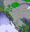 | 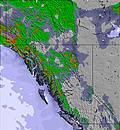 | 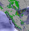 | 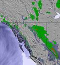 | 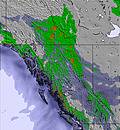 |  |  | ||||||||||||
— | — | — | — | — | — | — | — | — | — | — | — | — | — | — | — | — | — | — | |
— | — | — | — | — | — | 4 | — | — | — | — | — | — | — | — | — | — | — | — | |
max°C | 22 | 23 | 28 | 24 | 21 | 25 | 16 | 14 | 16 | 13 | 17 | 23 | 19 | 23 | 27 | 22 | 24 | 28 | 23 |
min°C | 15 | 19 | 27 | 15 | 17 | 23 | 7 | 10 | 16 | 7 | 11 | 22 | 14 | 18 | 26 | 17 | 20 | 28 | 13 |
15 | 19 | 27 | 14 | 17 | 23 | 2 | 6 | 14 | 5 | 10 | 22 | 14 | 18 | 26 | 17 | 20 | 28 | 11 | |
41 | 44 | 27 | 33 | 46 | 34 | 77 | 56 | 43 | 54 | 41 | 26 | 30 | 33 | 22 | 24 | 28 | 12 | 18 | |
4700 | 4450 | 4600 | 4700 | 4300 | 4350 | 3750 | 3300 | 3600 | 4050 | 4000 | 4050 | 4150 | 4100 | 4450 | 4450 | 4500 | 4600 | 4550 | |
— | 4:58 | — | — | 4:58 | — | — | 5:00 | — | — | 5:01 | — | — | 5:01 | — | — | 5:03 | — | — | |
— | — | — | 8:45 | — | — | 8:44 | — | — | 8:43 | — | — | 8:42 | — | — | 8:40 | — | — | 8:40 | |
Light rain (total 4.0mm), mostly falling on Mon night. Warm (max 28°C on Sun afternoon, min 7°C on Mon night). Winds increasing (calm on Sun morning, fresh winds from the NE by Mon night).
Mostly dry. Warm (max 28°C on Fri afternoon, min 7°C on Tue night). Winds increasing (calm on Thu morning, fresh winds from the SW by Fri afternoon).
Latest snow reports near Selkirk Powder:
| Top snow depth: | — |
|---|---|
| Bottom snow depth: | — |
| Fresh snowfall depth: | — |
| Last snowfall: | 21 Jun 2025 |
| Snow Alerts | Create Alert |
0.0 | Bluebird Powder days Fresh snow, mostly sunny, light wind. |
|---|---|
0.0 | Powder days Fresh snow, limited sun, any wind. |
0.0 | Bluebird days Average snow, mostly sunny, light wind. |
The above table gives the weather forecast for Selkirk Powder at the specific elevation of 1361 m. Our sophisticated weather models allow us to provide snow forecasts for the top, middle and bottom ski stations of Selkirk Powder. To access the weather forecasts for the other elevations, use the tab navigation above the table. For a wider view of the weather, check out the Weather Map of United States.
Click here to read further information on freezing levels and how we forecast our temperatures.
The Selkirk Powder skiing weather widget is available to embed on external websites free of charge. It provides a daily summary of our Selkirk Powder snow forecast and current weather conditions. Simply go to the feed configuration page and follow the 3 simple steps to grab the custom html code snippet and paste it into your own site. You can choose the snow forecast elevation (summit, mid-mountain or bottom lift) and metric/imperial units for the snow forecast feed to suit your own website…. Click here to get the code.
View detailed snow forecast for Selkirk Powder at:
snow-forecast.com


 Nearest