

Global Weekly Snow Roundup #314
Weekly Global Snow News, updated 14 May 2026: Fresh snowfall in Argentina, Australia and Lesotho signals winter’s approach, while Japan maintains the world’s deepest snowpack.

Next 3 days weather summary:A dusting of snow giving way to moderate rain (total 19.0mm) heaviest on Mon night. Freeze-thaw conditions (max 8°C on Mon afternoon, min -3°C on Sat night). Wind will be generally light. | Days 4-6 weather summary:Moderate rain (total 18.0mm), heaviest on Tue night. Very mild (max 12°C on Thu afternoon, min 4°C on Tue morning). Wind will be generally light. | |||||||||||||||||
Saturday 16 | Sunday 17 | Monday 18 | Tuesday 19 | Wednesday 20 | Thursday 21 | |||||||||||||
AM | PM | night | AM | PM | night | AM | PM | night | AM | PM | night | AM | PM | night | AM | PM | night | |
light snow | light snow | snow shwrs | clear | rain shwrs | rain shwrs | rain shwrs | risk thun- der | light snow | cloudy | light rain | light rain | light rain | rain shwrs | light rain | light rain | rain shwrs | rain shwrs | |
km/h | ||||||||||||||||||
Snow map |  |  |  |  |  |  | ||||||||||||
2 | 1 | — | — | — | — | — | — | — | — | — | — | — | — | — | — | — | — | |
— | — | — | — | 1 | 1 | 1 | 3 | 13 | — | 2 | 5 | 2 | 2 | 3 | 1 | 2 | 1 | |
max °C | 0 | 1 | 0 | 3 | 5 | 4 | 7 | 8 | 6 | 7 | 9 | 6 | 8 | 8 | 7 | 9 | 12 | 10 |
min °C | 0 | 0 | -3 | 1 | 5 | 1 | 5 | 8 | 2 | 4 | 9 | 5 | 6 | 8 | 5 | 6 | 12 | 7 |
-3 | -3 | -3 | 1 | 5 | 0 | 4 | 8 | 2 | 4 | 9 | 5 | 6 | 6 | 5 | 5 | 11 | 7 | |
95 | 89 | 90 | 79 | 84 | 86 | 77 | 76 | 98 | 79 | 82 | 98 | 81 | 83 | 93 | 75 | 61 | 89 | |
1600 | 1750 | 1200 | 2050 | 2300 | 1900 | 2400 | 2600 | 2100 | 2500 | 2700 | 2550 | 2650 | 2750 | 2550 | 2750 | 2950 | 3050 | |
5:35 | — | — | 5:33 | — | — | 5:33 | — | — | 5:31 | — | — | 5:31 | — | — | 5:30 | — | — | |
— | — | 8:42 | — | — | 8:43 | — | — | 8:44 | — | — | 8:45 | — | — | 8:46 | — | — | 8:47 | |
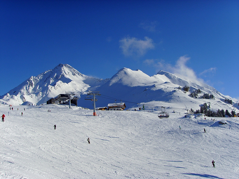
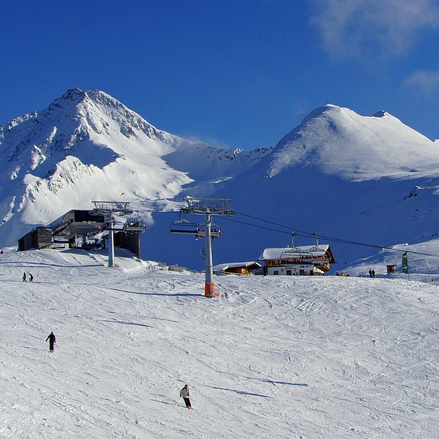
Latest snow reports near Mayrhofen:
| Top snow depth: | 0 cm |
|---|---|
| Bottom snow depth: | 0 cm |
| Fresh snowfall depth: | 25 cm |
| Last snowfall: | 15 May 2026 |
| Snow Alerts | Create Alert |
0.0 | Bluebird Powder days Fresh snow, mostly sunny, light wind. |
|---|---|
0.1 | Powder days Fresh snow, limited sun, any wind. |
0.0 | Bluebird days Average snow, mostly sunny, light wind. |

The above table gives the weather forecast for Mayrhofen at the specific elevation of 1565 m. Our sophisticated weather models allow us to provide snow forecasts for the top, middle and bottom ski stations of Mayrhofen. To access the weather forecasts for the other elevations, use the tab navigation above the table. For a wider view of the weather, check out the Weather Map of Austria.
Click here to read further information on freezing levels and how we forecast our temperatures.
Overall 4.4 Based on 35 votes and 52 reviews
I have read varied reports on Mayrhofen, but overall, I feel it does what it says on the tin.../it ban be wild, sedate or family fun, offering something for everyone. 1st, its a very quick transfer from Munich or Innsbruck (the latter airport can be tricky weather wise and flight cost) by car or train. 2nd, The new Penkenbahn gondola has by and large removed the congestion at peak times up and down. 3rd, The town offers a great mix of restaurants, bars and cafe's, good apres-ski at various points, Ice bar, Bruck and Stadl (typical Austrian fayre) and other quieter but nonetheless good fun. The 4th, Zillertell pass will at minimum connect you to Zell am Ziller, Hintertux and the main areas of Ahorn and Penken. For families you'll find the ski schools operating at the Penken and this means that parents can ski quite widely and always get back to the school area for lunch/meeting up etc, which is quite a bonus and reassuring. The pistes are a mix of blue crusing and red a little more challenging (yes, the piste ratings aren't as aggressive as France), but the blacks are genuinely achievable for a good/intermediate skier and the Harakiri brilliantly positioned for the adventurous and fun on fresh snow and deeply challenging in compact/ice conditions. Best viewed from a chairlift that passes up the side of the piste! So, it gets a big tick from me. Brits have been coming here for years for a reason. You should put this on your calendar, along with St Anton, 3 valleys, Morzine/Avoriaz, Zermatt, Dolomites, Espace Killy and Otzal valley (obergurgl, Hochgurgl, Solden) So naysayers, back in the box and try Mayrhofen. The deli at the bottom of the Penken is great fun and good value, Brasserie Q, Mr Lei's, Mo's Diner and Pane Vino great places to eat to name a few.
flyer1956 from United Kingdom writes:
I have read varied reports on Mayrhofen, but overall, I feel it does what it says on the tin.../it ban be wild, sedate or family fun, offering something for everyone. 1st, its a very quick transfer from Munich or Innsbruck (the latter airport can be tricky weather wise and flight cost) by car or train. 2nd, The new Penkenbahn gondola has by and large removed the congestion at peak times up and down. 3rd, The town offers a great mix of restaurants, bars and cafe's, good apres-ski at various points, Ice bar, Bruck and Stadl (typical Austrian fayre) and other quieter but nonetheless good fun. The 4th, Zillertell pass will at minimum connect you to Zell am Ziller, Hintertux and the main areas of Ahorn and Penken. For families you'll find the ski schools operating at the Penken and this means that parents can ski quite widely and always get back to the school area for lunch/meeting up etc, which is quite a bonus and reassuring. The pistes are a mix of blue crusing and red a little more challenging (yes, the piste ratings aren't as aggressive as France), but the blacks are genuinely achievable for a good/intermediate skier and the Harakiri brilliantly positioned for the adventurous and fun on fresh snow and deeply challenging in compact/ice conditions. Best viewed from a chairlift that passes up the side of the piste! So, it gets a big tick from me. Brits have been coming here for years for a reason. You should put this on your calendar, along with St Anton, 3 valleys, Morzine/Avoriaz, Zermatt, Dolomites, Espace Killy and Otzal valley (obergurgl, Hochgurgl, Solden) So naysayers, back in the box and try Mayrhofen. The deli at the bottom of the Penken is great fun and good value, Brasserie Q, Mr Lei's, Mo's Diner and Pane Vino great places to eat to name a few.


 Nearest