WORLD SNOW ROUNDUP #227
Issued: 26 January 2022
By Patrick “Snowhunter” Thorne
European Roundup
North American Roundup
Asia Roundup
WORLD OVERVIEW
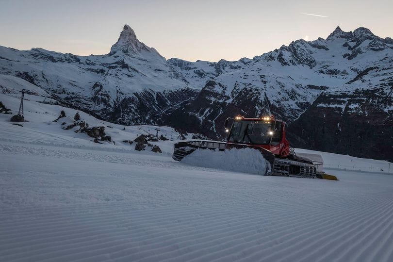
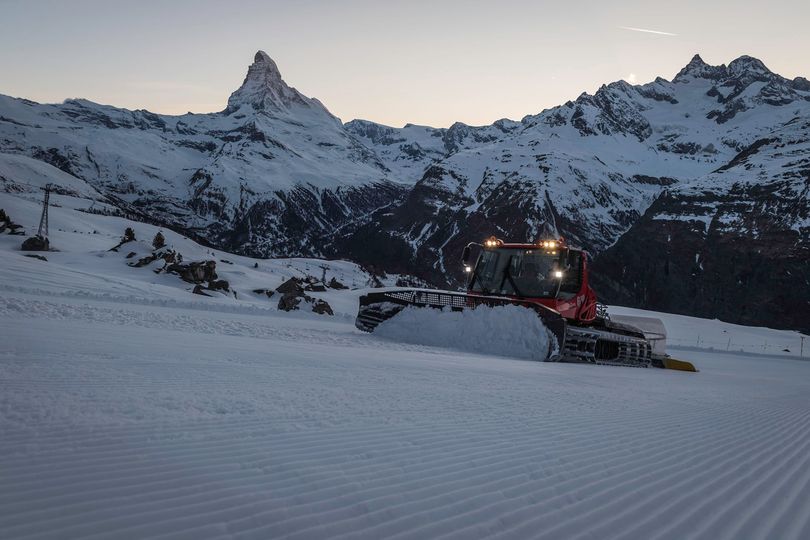
There has been a welcome return of snowfall to the Alps after a few weeks of sunshine with snow falling through the weekend at many resorts giving powder conditions to start the week. Other regions reporting decent dumps included parts of Scandinavia with big falls at last in western Norway as well as some parts of Sweden although across the North Sea Scottish hills remain brown. Down in southern Europe, it remained sunny in the Dolomites too although further east there was more snowfall in Bulgaria.
In North America, it has been a largely dry week for much of the western side of the continent although with cold temperatures for most. In fact, most have seen glorious sunshine daily. Further east, from the Midwest and Ontario on, much more changeable with very low temperatures for some areas and some fresh snowfall too.
Over in Asia, Japan continues to post some of the biggest snowfalls and snow totals. There was a perhaps auspicious snowfall in China’s capital Beijing where the 2022 Winter Olympics will begin soon. Low temperatures are the norm there in winter but natural snowfall is rare.
In areas of the Northern Hemisphere where snowfall is more unusual even in winter, snow has been reported in countries including Iraq and Saudi Arabia in the Middle East.
In the wider world, there’s been excitement in the Southern Hemisphere with the first snowfalls of 2022 reported in what’s mid-summer there. Ski areas in New South Wales, Australia and in New Zealand reported a decent covering and in the Andes of South America, the first snow was reported on mountain tops too.
EUROPE INTRODUCTION
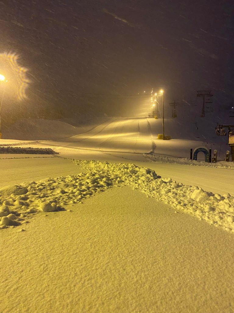
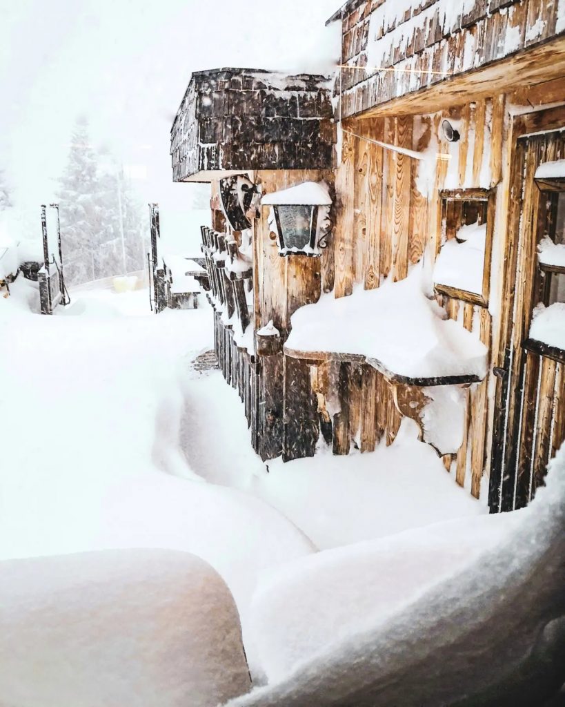
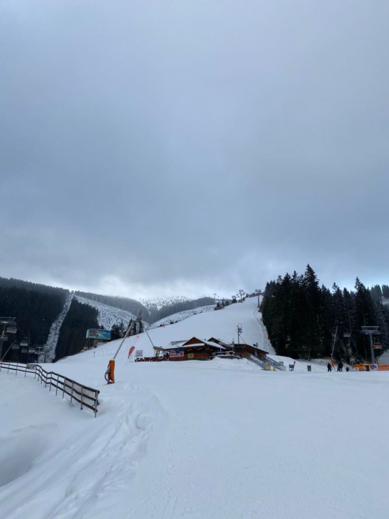
There’s been a good deal of snowfall for much of Europe since the end of last week although not everywhere. For some regions the snowfall is the first for several weeks, ending a period of consistent sunshine. The northern Alps have seen plenty of fresh snow with some areas reaching 50cm (20″) of new snow providing a great refresh of cover. However, areas to the south including the Dolomites and Pyrenees as well as the southern Alps have seen a different weather pattern and continued sunshine with little or no fresh snow reported. Strong winds were a factor across much of the heart of Europe though, impacting World Cup racing in snowy Kitzbuhel and sunny Cortina at the weekend. Elsewhere, Bulgaria, the Tatras and large parts of Scandinavia reported some good 20-50cm (8-20″) snowfall totals too while Highland Scotland remained largely dry and warmer than southern England.
AUSTRIA
AUSTRIA REPORT Austria appears to have had the best of the fresh snowfall over the past week with plenty of areas reporting up to 50cm (20”) of new snow over the weekend, and claims that a metre of snow had to be scraped off the Streif racecourse ahead of the downhill on Sunday, which had been delayed from Saturday because of the heavy snowfall then. The slalom was switched and raced then instead. Loser – Altaussee (60/255cm / 24/102”) moved up the snow depths tables to claim the deepest base in the Alps now, even more than the country’s glaciers. The snowfall was accompanied by very strong winds which closed higher lifts and entire glacier areas at times on Friday/Saturday but once the winds eased and the snowfall slowed or stopped many Austrian resorts announced a perfect powder Sunday.
AUSTRIA FORECAST After a sunny midweek spell following last weekends snowfall another front is expected to bring more snow to the region to end this week with 15-30cm (6-12”) more forecast by Sunday for many areas.
SWITZERLAND REPORT There was a little snowfall at the weekend in Switzerland with most areas reporting just 5-10cm (2-4”) but some areas like Lötschental (39/178cm / 16/71”) reporting 30cm (a foot) of fresh snowfall. So the country is divided between those reporting plenty of powder and others still on hard-packed snow. Regardless, most areas are fully open or nearly so. Engelberg (20/240cvm / 8/96”) is posting the country’s deepest base, The 4 Valleys (40/100cm / 16/40”) has the most terrain open in the country with around 360km, nearly 90% of the available terrain.
SWITZERLAND FORECAST Sunny and rather warm across most of Switzerland for the remainder of this week with temperatures climbing a degree or two above freezing even at altitude and well above in lower valleys. Temperatures start to drop towards the weekend with light to moderate snowfalls forecast to end the week in the eastern half of the country.
FRANCE REPORT Another largely sunny week in the French Alps with temperatures hovering a few degrees above freezing in the valleys, colder higher up. So little change on a week ago other than the snow being that bit older. With little fresh snowfall since the big falls of the first half of December the snowpack is below average but still adequate for most areas to be fully open. Off-piste powder is getting hard to find though. La Clusaz (45/230cm / 18/92”) is posting the deepest base in the Alps although some centres have snow lying 50cm deeper down in the Pyrenees.
FRANCE FORECAST There’s almost no change in the forecast over the next seven days with sunshine expected through the weekend. There are early signs of snowfall to start next week though, currently looking like fairly decent accumulations could be possible.
ITALY REPORT Italy largely missed out on the weekend snowfall and has continued its almost exclusive sunny January. Those watching the women’s weekend World Cup races from Cortina D’Ampezzo will have seen the Saturday races have a lowered start gate due to fairly violent winds on the top of the mountain and the wind was still very strong lower down, an issue across the Dolomites. Some regions are impacted by the thin cover at lower elevations (The Milky Way/Via Lattea remains only about 75% open. However, that is an increase on a week ago, despite continuing to post only a 20-40cm 8-16” base), most are able to fully open. Trentino’s San Martino (50/210cm / 20/84”) is posting the deepest snow.
ITALY FORECAST There are signs of a change in the weather in the north and west with snow forecast for Trentino from Thursday/Friday and continuing through the weekend. That said for many areas that do get snow it currently looks light to moderate so probably only 10-20cm (4-8”) accumulations over three-four days. However, parts of South Tyrol and Veneto look like they’ll see out January in the sunshine. Temperatures stay cold on the slopes regardless.
GERMANY REPORT Conditions continue to improve in Germany with fresh snowfall in many areas at the end of last week. About three-quarters of German ski areas are now open, up from only a third a month ago, as more wintery temperatures and snowy conditions have allowed more of the country’s smaller, more low-lying centres to finally open. The major centres have been open since before Christmas as normal though with Reit im Winkl (80/140cm / 32/56”) posting the most terrain open in the country (40km/25 miles) and Germany’s highest slopes on the Zugspitze (130/150cm / 52/60”) posting marginally the deepest snow.
GERMANY FORECAST There’s mostly sunny weather across much of the country for the remainder of this week but a fresh front should bring 20-30cxm (8-12”) of snowfall to parts of the country including Bavaria at the end of the week and into the weekend.
SCANDINAVIA REPORT We seem to have winter proper arriving in Scandinavia at last with consistent cold and snowy weather and the first big snowfalls of the season to date reported in Norway, Bjorli (120/125cm / 48/50”) scoring over 50cm (20”) in 48 hours over the final few days into last weekend. It’s one of the first to break through the meter-depth mark in the region so far this season. Coastal Voss and northern Narvik have also reached metre (40”) snow depths on their upper slopes. It’s a similar story over in Sweden with Tärnaby (40/120cm / 16/48” ) reporting the deepest base there. Most areas are not fully open yet, however, with the largest, Sweden’s Åre (50/92cm / 20/37”) reporting about three-fifths of its 91km of slopes currently accessible.
SCANDINAVIA FORECAST The forecast is for temperatures to stay well below freezing across the region and for the snow to keep dumping across the coastal west, but for drier, sunnier weather inland.
SCOTLAND REPORT The picture in Scotland has unfortunately not improved a good deal over the past week with temperatures remaining fairly mild and dry. The country’s five centres have got small snow areas open at their bases, perhaps the largest at Cairngorm and Glenshee created thanks to all-weather snowmaking machines. But all are waiting for a more consistent dip in temperatures and hopefully a good natural snowfall to rebuild bases on higher slopes.
SCOTLAND FORECAST The general trend appears to be gradually cooler and with more precipitation and the long term forecast is for snow next week to end January and start February. Unfortunately, that’s still a little way off for certainty but hopefully, things will move as expected now.
SPAIN / ANDORRA REPORT The snowfall in the northern Alps, Central and Eastern Europe has not extended down into the Pyrenees, which looks like it will complete January with almost non-stop sunshine. Base depths remain healthy though after big snowfalls in December and most of the region’s ski areas remain fully open. However, they are dropping slightly with warmer weather in the past week and Europe’s deepest base is no longer above 3m (10 feet) at Porté Puymorens (100/280cm / 40/112″) in the French Pyrenees, but is down 20cm (8″) on a week ago and has been overtaken by Russia’s Rosa Khutor (128/322cm / 51/129”). The largest areas open in the Pyrenees are slightly larger now though compared to a week ago with Andorra’s Grandvalira (100/150cm / 40/60”) posting the most with 90% of its slopes now open (190 of 210km).
SPAIN / ANDORRA FORECAST There’s no clear change in the long term weather pattern in the Pyrenees as we head towards February with another week of sunshine and temperatures between 10 below and 5 above freezing forecast for the region.
BULGARIA / ROMANIA REPORT It has been a very snowy week in southeastern Europe with Bulgarian ski areas posting up to 50cm (20 inches) of fresh snowfall over the past seven days, heaviest at the weekend, giving a nice refresh of the slopes which were already in good shape from earlier accumulations. All of the ski areas in the region are now fully open with Borovets (130/160cm / 52/64”) posting the deepest base and Bansko (10/100cm / 4/40”) the most terrain open.
BULGARIA / ROMANIA FORECAST The week ahead looks largely dry, perhaps with just some light midweek snowfall. Temperatures ranging from a few degrees above freezing to 15 below, fluctuating between sunny and overcast skies in fairly equal measure.
CZECH REPUBLIC / SLOVAKIA REPORT A continually improving picture in the northeastern European mountains with one of the most established ski areas in the Czech Republic, Špindlerův Mlýn, reporting another 15cm (6″) of fresh snowfall at the weekend, meaning it now has about two-thirds of its terrain open, up from a third a week ago. The increase is thanks to ongoing wintery conditions and fresh snowfall over recent weeks following a warm start to the season at the end of last year. Over in Slovakia the region’s largest resort, Jasna (60/120cm / 24/48”), posted a 320cm (12”) accumulation on Sunday morning.
CZECH REPUBLIC / SLOVAKIA FORECAST After a brief sunny lull midweek snowy conditions are forecast for the week ahead with light to moderate accumulations daily, which could add up to 50cm (20”) more for some regions by the end of the week. Temperatures between freezing and 15 below.
NORTH AMERICA
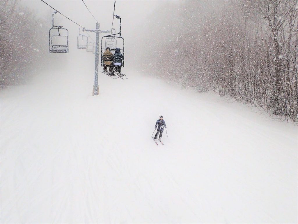
NORTH AMERICA INTRO There’s an east/west split in North America at present with the east now seeing the colder and snowier weather. In the west, it has been a largely sunny week, a little too warm in places causing avalanche danger in the backcountry as the snowpack stability is impacted by the warmth. Over in the east, the opposite has been true with temperatures dropping more than 30 degrees below freezing in some parts of the northeast. There’s been some light to moderate snow showers here too.
ROCKIES REPORT Another mostly sunny week in the Rockies with temperatures dropping to 20 below at times in the upper mountains. Some ski areas did report a few inches of snowfall on Tuesday to freshen things up a bit. Colorado’s Wolf Creek (78/89″ / 196/223cm) continues to post the deepest base in the region with Utah’s Alta (36/87″ / 90/218cm) close behind.
ROCKIES FORECAST The current slightly unsettled weather should bring more light fresh snowfall for the next few days before the skies return to clear and sunny through the weekend. Temperatures remain very cold on higher slopes.
USA WEST REPORT Another week of fairly stable weather in the West US with mostly sunny skies and temperatures in the range of one or two degrees above freezing down to five to ten below. Mammoth (91/162” / 228/405cm) continues to post the region, country and continent’s deepest upper slope base depth, the only one above 4m/13 feet. Further north in Oregon, Timberline (104/136” / 260/340cm) has a little more lying at its base and is already looking good for its long season through to September. So the snow is getting old with less fresh to be found after little new for much of January now but after the huge falls in late December there’s still a tonne lying and most trails are open. Probably the biggest impact on the skiing in the past week have been strong winds, which impacted higher terrain particularly at the weekend.
USA WEST FORECAST Still no major signs of change on the horizon with a similar pattern of sunshine and low temperatures for the week ahead.
MIDWEST REPORT Temperatures have stayed very cold in the Midwest over the past week and there have been light to moderate snowfalls at times, meaning most areas are in good shape with most terrain open and fresh natural snow on top of what is often a predominantly machine-made base. Crystal Mountain (46/58” / 115/145cm) in Michigan is posting the region’s deepest base and all 50+ trails open.
MIDWEST FORECAST Conditions look set to stay very cold in much of the region dropping as low as 30 below freezing at times. There’s not a lot of snow in the forecast but skies will be predominantly overcast in most areas and there are chances for light to moderate snowfalls at times almost daily across the region.
USA EAST REPORT It has been another very cold week in the east with frequent snow showers., Temperatures have been down at 10-30 degrees below freezing and it seems to have been snowing every other day, with sunny days in between. Killington (20/26” / 50/66cm) has the most terrain open in the region, now reaching about 90% of its terrain skiable. It has been opening lifts and terrain for the first time this season over the past week thanks to the continuing cold conditions for snowmaking and the natural snow showers too. Sunday River (20/40” / 50/100cm) has almost as much open and the deepest base of the major ski areas in the region
USA EAST FORECAST Staying very cold for the coming week into February. Sunny in most areas for the rest of this week but with snow showers moving in ahead of the weekend, which looks to be a cloudy one.
CANADA
CANADA WEST REPORT Some fresh snowfall last week saw a change in the order of deepest-snowpack-reporting with Whistler Blackcomb (0/223cm / 0/89”) dropping from the top spot and Kimberley (93/272cm / 37/109″) over on the opposite eastern side of British Columbia, moving to post the region and Canada’s deepest base. Unfortunately, the warmer temperatures at low elevations on Canada’s Pacific Coast has wiped out the foot of snow that was lying in the resort although Whistler still reports 98% of its slopes, famously North America’s most extensive, still open. The warm and sunny conditions led to an unusually severe avalanche danger warning for backcountry skiers in southern B.C. and western Alberta due to an increasingly unstable snowpack.
CANADA WEST FORECAST There’s very little snow in the forecast for the week ahead, with sunnier skiers the norm in the west of the region, cloudier in the east. Temperatures staying below freezing other than over on the Pacific coast and in the south where they’ll continue to creep a few degrees above at the base in the daytime, double digits below at altitude and at all altitudes in the east.
CANADA EAST REPORT The very low temperatures have continued in Canada with some ski areas seeing -35C and closing for periods as it is just too cold at times for safe opening. There have been some fresh snowfalls too, most recently on Tuesday, between clear sunny days. And, other than the extreme cold at times, the overall picture is good. Tremblant (30/254cm / 12/102”) continues to post the deepest base in the region by some distance as well as the most terrain open.
CANADA EAST FORECAST It looks like similar weather to see out January in eastern Canada with super-low temperatures and a mixture of dry sunny days and snowy ones as fronts move through. Friday currently looking the best bet for more significant snowfall.
ASIA
JAPAN REPORT Across Japan snowfall is the norm and it has kept falling, if not with the intensity of the first half of the month, over the past week. Niseko (160/330cm / 64/132″) reported around 40cm (15″) in total in the last seven days, down from more than a metre the week before, but few are complaining with cold temperatures, clear skies and deep powder lying. (There was a rare snowfall in Beijing to help raise national spirits further in China ahead of the start of the Olympics next week. Low winter temperatures are the norm in the region but it’s a very dry climate so snowfall is less common.)
JAPAN FORECAST Temperatures staying a little below freezing at the mountain base, dropping to ten degrees below on higher slopes and overnight, largely clear skies with light snow showers for most areas, the snowfall getting heavier towards the weekend.


