WORLD SNOW ROUNDUP #181
Issued: 03 March 2021
By Patrick “Snowhunter” Thorne
European Roundup
North American Roundup
Asia Roundup
EUROPE INTRODUCTION
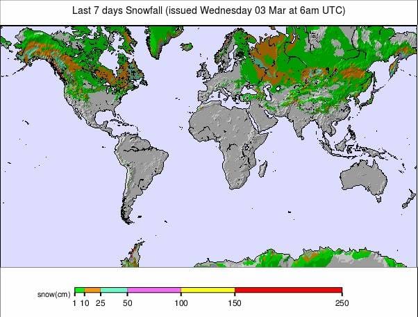
It is the start of March and after nearly a fortnight of predominantly springlike, sunny, warm weather across Europe it is now actually springtime *according to the meteorological measure). So the overnight freezing followed by daytime thawing of the snowpack seems more normal and less earlier than usual. The past week has been much the same as the one before in Europe, mostly warm and sunny for most ski areas. But temperatures have cooled a little and there was a thin band of snowfall in the Alps at the start of the weekend. Most areas are dry again now but it looks like the weather will cool through the remainder of this week with the chance of some light snowfall towards the weekend.
As to pandemic operations, there’s little new to report. France, Germany and Italy, where ski slopes remain closed, are all due to review their positions in the coming few days but optimism for any change is not high.
AUSTRIA
AUSTRIA REPORT| Almost a fortnight of warm, sunny and dry weather in Austria ended at the weekend with fresh snowfall, at last, reported at several areas across the country, with Salzburgerland seeing the most. Not that it was a lot, Obertauern (120/140cm / 48/56”) reported 10cm (4 inches) to give the pistes a much needed freshen up after the thawing temperatures. For most others, it was more like 5cm/2 inches, if anything. It was back to sunshine soon afterwards though, and many areas didn’t see any snow, although it has cooled a little, more often single figures above freezing and dropping well below overnight. In terms of the pandemic, there’s little change on a week ago except for the good news that St Anton has re-opened and Solden plans to re-open next weekend, both closed a fortnight ago as stricter pandemic operating procedures were brought in. Against that news though, the Skiwelt, which had been maintaining one of the largest open ski areas in the Alps, has decided it has to close after a 70 day ski season this Sunday, saying it is yet to have a day where it breaks even and actually losing money every single day it did open, sometimes with more staff than skiers.
AUSTRIA FORECAST| The sunny weather is set to continue until the weekend when a second period of snowfall is expected. Temperatures are a little cooler than they have been but still well above freezing in the valleys and in the daytime on the slopes too to quite high altitudes. So freeze-thaw conditions are the norm here.
SWITZERLAND
SWITZERLAND REPORT| It has been another predominantly warm and sunny week on Swiss ski slopes. The country remains the only major alpine ski nation where hotels and ski slopes are open but it was announced that although shops can now re-open, restaurants will be staying closed for another three weeks. Engelberg (25/485cm / 10/194″) continues to have the deepest base in the country, and in Europe. The 4 Valleys (40/225cm / 16/90″) has the most terrain open in Europe with some 374km (225 miles) of slopes skiable to those permitted to get to them, although it has announced it will begin reducing terrain open from this weekend to keep costs down.
SWITZERLAND FORECAST| After a fortnight of plus temperatures and mostly sunny weather the trajectory through this week is definitely getting cooler and into subzero temps down to low elevation by the weekend. A band of snowfall around Friday is also forecast, currently looking like 10-20cm accumulations likely before a return to drier weather for the weekend.
FRANCE
FRANCE REPORT| The last government announcement on ski area closures in France had resorts closed throughout February. We’re now into March with no sign of any announcement on what might happen this month but with France still battling the virus and restaurants closed, re-opening ski areas now before the end of the season does not seem a high priority. Of course, resorts themselves remain open and people are skiing to some extent, either ski touring or, in some resorts (Courchevel), having the option of taking a taxi to the top of a 2km groomed descent or at other resorts, being pulled up behind a horse. The weather has been mostly warm and sunny across the country with just a few areas reporting some light snowfall at the weekend. Resorts like Chamonix, Tignes and Val Thorens where the season would normally continue into May are looking pretty good with some 2-3 metres deep if they do manage to open before the season ends.
FRANCE FORECAST| Sunshine and warm temperatures continue to midweek, but then we should see a return to sub-zero temperatures right down to the valley floor and some (probably) light to moderate snowfall to end this week before a dry, but still cold, weekend.
ITALY
ITALY REPORT| Italy has got firmer dates in places, than France, for reviewing its ski slope closure policy, the next ‘resorts can open by’ date coming up this weekend. Will it happen? After the 11th hour decision not to open last time optimism is much lower but, currently, it simply remains to be seen. As with the rest of Europe, the past week has seen predominantly warm and sunny weather on Italy’s ski slopes with no fresh snowfall to report.
ITALY FORECAST| It looks like we’ll end up with a fortnight of nearly nonstop sunshine and warm weather for Italy before things finally look like they’ll begin to change at the weekend. Temperatures will dip to freezing or below from top to bottom of the slopes with some areas seeing a little snowfall, others just heavy cloud.
GERMANY
GERMANY REPORT| The German government will announce imminently whether ski areas there can finally open for the 20-21 season this month. As it is many German resorts have now said they won’t open at this late stage anyway although the high altitude Zugspitze glacier has said they will if they get the go-ahead, and hopefully stay open into May. As with the rest of the Alps, it has been predominantly sunny and warm over the past week so there has been quite a rapid thaw at lower altitude centres.
GERMANY FORECAST| Not quite so sunny as it has been over the coming week and temperatures will be heading back towards freezing as we approach the weekend but currently there’s not much fresh snowfall in the forecast.
SCANDINAVIA
SCANDINAVIA REPORT| Changeable conditions in Scandinavia with temperatures hovering around freezing. Quite a few Norwegian ski areas reported 10-15cm (4-6 inches) of snowfall at the start of the weekend before a warmer, sunnier Sunday. There’s been light snowfall since but also rain on lower slopes for some areas. Riksgransen, up in the Arctic circle in Northern Sweden, opened for its season on Friday and early visitors are seeing a nice powdery start to the winter with over 50cm of snowfall in the first few days of operations, the biggest snowfall in Europe this past week in fact. It’s due to stay open through to late May with skiing under the midnight sun in the final weeks of the season.
SCANDINAVIA FORECAST| A mixed picture through the remainder of this week with rain and snow initially interspersed with dry, sunny periods. Getting progressively colder and snowier into the weekend. Snowfall continuing through midweek further north and temperatures remaining well below freezing. Staying cold but less snowfall into the weekend.
SCOTLAND
SCOTLAND REPORT| It has been another week of predominantly warm, often sunny weather in the Scottish Highlands and these plus temperatures, often reaching double figures above freezing in the valleys, is starting to impact the snow cover, good though it is. Hillsides are starting to turn green and brown in places although webcams still show ski runs complete. It currently seems unlikely that Scottish ski centres will get to open until late April, and then perhaps only to people living locally if there’s any snow left to open at all.
SCOTLAND FORECAST| Now that spring is here it does look like the springlike weather in the Highlands will turn increasingly wintery over the coming week which will hopefully stop or at least slow the rate of thaw.
SPAIN / ANDORRA
SPAIN / ANDORRA REPORT| A week of fairly warm weather and no fresh snowfall in the Pyrenees where the position remains as it has done for the past few months; the French Pyrenees closed in terms of ski lifts operating and ski areas in Andorra and Spain (some) open but only to people living locally. That means most continue to operate around a quarter to a third of their terrain to fit demand, with Spain’s largest area Baqueira Beret (110/130cm / 44/52”) and Grandvalira (40/95cm / 16/38”), in Andorra, operating the largest areas. It’s not been too warm since the weekend, still above freezing but only a few degrees.
SPAIN / ANDORRA FORECAST| It’s looking like predominantly dry weather continuing through the coming week, with temperatures fluctuating a few degrees on either side of freezing. Some light showers are possible but with temperatures what they are they could fall as rain, especially at lower elevations, snow higher up.
BULGARIA / ROMANIA REPORT
BULGARIA / ROMANIA REPORT| The warm weather in southeastern Europe has impacted snow depths a little. Bansko’s (20/160cm / 8/64”) long home run has lost another third of it’s lower thickness and is now half what it was a fortnight ago, so colder weather would be needed for it to make it through to Easter. To be fair, up on the main ski area slopes it has remained mostly sub-zero, colder than a week ago despite the sunshine. Otherwise, we have that classic springtime freeze-thaw pattern, but not yet too warm in the daytime for any major damage to slope cover higher up.
BULGARIA / ROMANIA FORECAST| It will remain dry and sunny into next week with temperatures getting to double digits below freezing on higher slopes overnight, double digits above freezing down in the valleys by afternoon, so that snowline gradually moving up as we move into springtime. There’s a small possibility of a centimetre or two of snowfall at the weekend.
CZECH REPUBLIC / SLOVAKIA
CZECH REPUBLIC / SLOVAKIA REPORT| The Czech and Slovak Republics remain in lockdown and in fact the Czech Republic, which currently has the highest rates of infection in Europe, has strengthened theirs further, so there’s no sign of ski areas in either country opening imminently. Slovakia’s leading resort of Jasna has had the country’s famous skier Petra Vlhova training there this past week though, ahead of the resort hosting World Cup racing this week. The FIS has given the go-ahead for the event so they’re happy with the snow conditions. Snow conditions are springlike here as in the Alps to the south with warm and sunny weather throughout the past week.
CZECH REPUBLIC / SLOVAKIA FORECAST| A predominantly sunny week ahead but much colder with temperatures dropping below freezing and rarely climbing above from about Thursday on. Higher slopes could see overnight lows of 15 below. Some cloud but no snowfall expected around Friday.
NORTH AMERICA
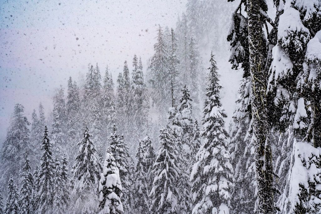
The snow keeps falling in northwestern North America with a resort in Washington State now reporting the snow depth there has passed the 20 feet (six-metre) mark, not just the deepest on the continent but in the entire world. The snow in the wider region has been remarkable over the past month in fact. Several ski areas in Utah reported the most snowfall in two decades over a 72 hour period a few weeks ago and now resorts in Wyoming are reporting their snowiest ever February. At least since they started measuring anyway.
Elsewhere on the continent, the past week has continued the, generally, low temperatures and there has been some fresh snowfall reported for many areas on the east coast too. So, all in all, things are looking good for the start of (meteorological) spring.
ROCKIES
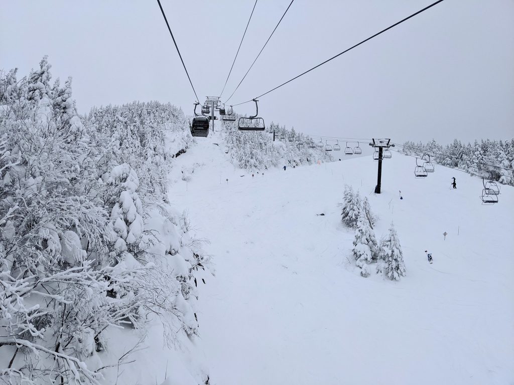
ROCKIES REPORT| There’s quite a north-south divide in the Rockies with, essentially, ski areas in the north seeing some record-breaking snowfall in February, whilst in the south snow cover remains below average. That said, there has been fresh snowfall across the region over the past week, although again much heavier in the north: Idaho, Montana, Wyoming and Utah than down in Colorado. Snowbasin (102/102” / 254/254cm) posted one of the bigger falls with 30 inches (80cm) in three days over the weekend. Park City (59/73” / 147/178cm), the country’s largest ski area, finally has almost all of its terrain open, 320+ of its 340+ runs, after another foot (30cm) of snowfall there.
ROCKIES FORECAST| After the weekend snowfall it has been dry and sunny, although staying cold, in the Rockies. A little more cloud and the possibility of some snowfall towards the end of the week but probably just a few flakes this time.
USA WEST
USA WEST REPORT| Ski areas in northwestern North America, particularly in Washington State, continue to post the most snowfall in the US, on the continent and in the world with five of the snowiest resorts on the planet this past week all in Washington. Steven’s Pass (151/193” / 378/483cm) tops the snowfall table with 7.5 feet (235cm) in the past seven days. Alpental (139/259” / 348/648cm), in second place with 80 inches (201cm) of new snow this week, the country/continent/world’s deepest reported snow depth and the first to pass the 20 feet (6 metre) mark this season. The snow has kept falling heavily all week with most areas reporting at least a foot a day. So much snow continues to lead to road closures and other practical access/opening issues, as well as high avalanche/tree well danger. But when resorts can open and skiers stick to safer areas, it’s powder heaven.
USA WEST FORECAST| It’s finally looking drier for the start of March/spring with only light snowfall expected into the weekend and several clear days too giving ski areas the chance to consolidate and take stock at last. Temperatures staying largely just below freezing so snow quality should hold up.
USA MIDWEST REPORT
MIDWEST REPORT| It’s largely business as usual in the midwest with all areas open and all slopes snow-covered at almost every ski area. Temperatures fairly good for the start of spring, generally sub-zero but occasionally creeping a degree or two above at the base, nothing likely to impact cover though. Some areas did have snowfall at the end of last week and at the weekend but it has been fairly dry everywhere in the region since Sunday. Crystal Mountain (60/60” / 151/151cm), in Michigan, is posting the deepest snow depth in the region.
MIDWEST FORECAST| It will remain cold over the coming week, rarely getting above freezing at most of the region’s ski areas and cold enough for snow-making systems to fire up as required. There’s no natural sunshine in the forecast with a mixture of overcast and sunny weather.
USA EAST
USA EAST REPORT| Moderately snowy in New England this past week. Stowe ( 30/60” / 76/152cm) had a nice weekend clocking up eight inches (20cm) of snowfall at the rate of a few inches daily, refreshing the snow cover each morning. It was a similar picture at many other New England ski centres. It got drier, then sunnier, to start this new week with very low temperatures once more though with overnight lows on the mountain dropping as far as 25 below freezing.
USA EAST FORECAST| Staying dry for the week ahead and cold, if not as cold as it was at the start of this week. Mostly overcast skies with sunny spells but becoming increasingly sunny by the weekend.
CANADA
CANADA WEST
CANADA WEST REPORT| A snowy week in Alberta and BC, as south of the border with resorts in the west seeing the most snow but even in Alberta, Lake Louise (152/187cm / 61/75”) posted around half a metre (20 inches) of snow in a couple of days into the weekend. Lots of powder to be skied and boarded across the region, including at famously snowy Fernie (100/235cm / 40/94”), which reported 25cm (10 inches) more snow to start the weekend. It has been a drier start to the week but with temperatures remaining below freezing under overcast skies at some areas, but some seeing the sun break through and in consequence temperatures climb a few degrees into positive territory down at the base.
CANADA WEST FORECAST| The dry, cloudy weather is expected to continue through the remainder of this week with temperatures remaining below freezing. Snowfall should return from the weekend.
CANADA EAST
CANADA EAST REPORT| It has been another snowier week in eastern Canada then there has been for much of this season with many areas posting 20-40cm of fresh over the weekend. Tremblant (60/60cm / 24/24”) reported 25cm (10”) in 48 hours and great glade skiing as well as having all of its trails groomed and ready. Similar conditions occur across the wider region.
CANADA EAST FORECAST| Cold and mostly dry through the coming week with temperatures predominantly 10 to 20 degrees below freezing still. A mixture of sunshine and overcast days but no snowfall in the forecast at present.
ASIA
JAPAN REPORT| After the heavy snowfall through much of January and February, it has been a comparatively quiet week on Japanese slopes, although most areas have still reported 50-100cm (20-40 inches) of fresh cover and snowfall season totals are past 10 metres (33 feet+) now for most areas too. Niseko (240/475cm / 96/190″) has had a mixture of snowy and sunny days through the past week, with recent days clear and sunny, although the wind has been a problem as it can be here on higher slopes. Temperatures are definitely getting more springlike now on the whole although some cold, snowy days at times still too.
JAPAN FORECAST| The trend remains towards spring freeze/thaw conditions with a daytime onus on the thaw as it gets quite warm through the latter half of this week. The chance exists of more snow arriving into the weekend though.


