WORLD SNOW ROUNDUP #179
Issued: 17 February 2021
By Patrick “Snowhunter” Thorne
European Roundup
North American Roundup
Asia Roundup
EUROPE INTRODUCTION
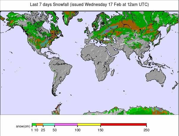
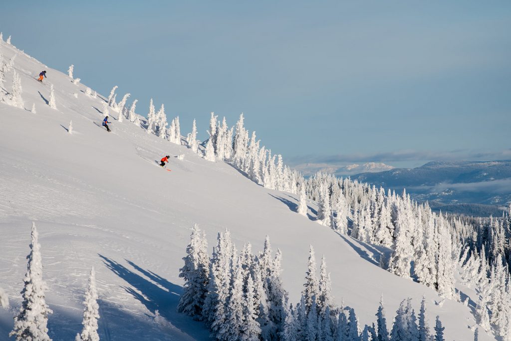
It has been a predominantly sunny week in most of Europe’s mountainous areas with some very low temperatures at times and not much fresh snowfall to report anywhere. That said, there has been some, 10-20cm (4-8 inches) in parts of the Alps and right down south in the Balkans.
With the pandemic still dominating and travel still at best very difficult but illegal for many, it generally remains only those who live in the country where the ski slopes are, sometimes only the region where they are, that can actually get to the slopes to ski them. In terms of the virus, the big news was supposed to have been that one of the world’s leading ski nations, Italy, had allowed its ski areas to start opening since Monday, with pandemic restrictions in place, of course. Instead, a government announcement late on Sunday extended the enforced closure of Italian ski centres to at least March 5th. Germany also has its ski areas closed and has now decided to extend its lockdown to March 7th, resulting in most ski areas there announcing that they no longer have any hope of opening for the 20-21 season. In further bad news, resorts in the Austrian Tirol are requesting skiers carry a negative virus test certificate issued within the previous 48 hours.
AUSTRIA
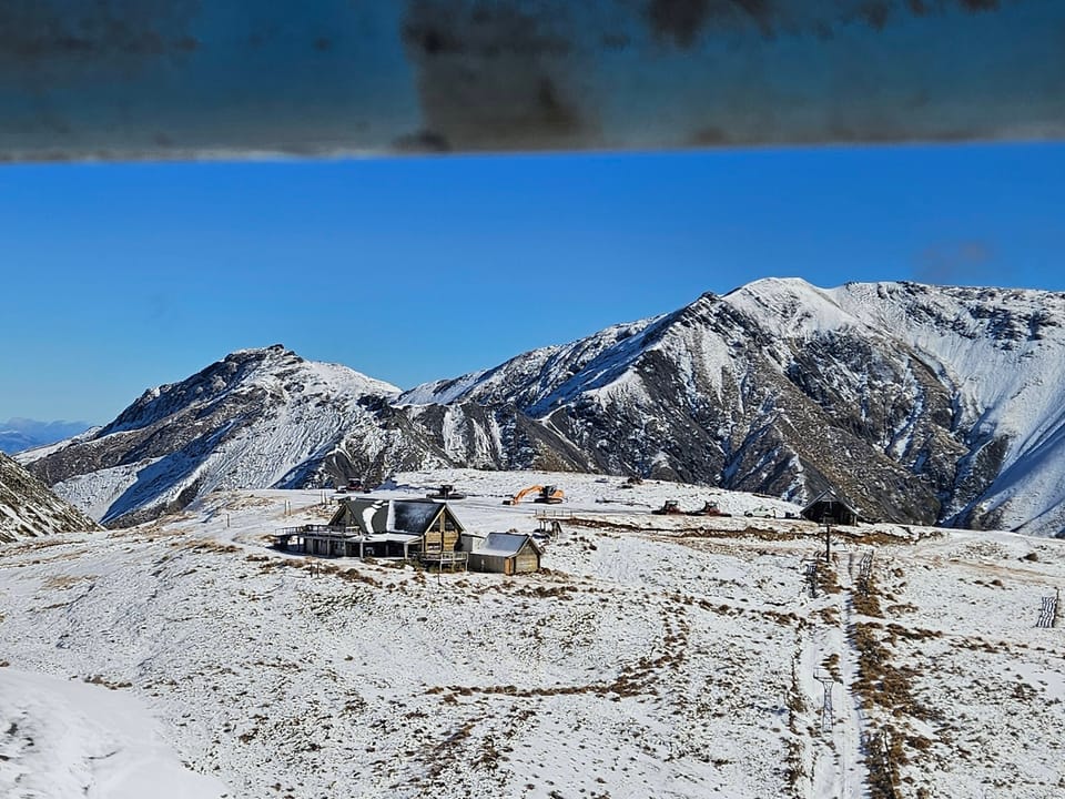
AUSTRIA REPORT| A largely dry and sunny week in the Austrian Alps with the few skiers able to access the country’s open slopes reporting glorious conditions on quiet runs. With mostly sunny days there’s been no fresh snowfall to report. The deepest bases remain on the country’s glaciers, with Hintertux (165/375cm / 66/150”), open year-round, having the deepest of all. This looks to be good news for late spring and summer glacier skiing in 2021, should travel limitations ease by then. The SkiWelt, with 150km (over 90 miles) of trails open, looks to be the biggest area open in Austria. The Arlberg has only 100km of its 300km+ of trails open due to the limited demand, resulting from pandemic travel restrictions. Solden announced on Monday that it was closing indefinitely due to the new stricter pandemic operating restrictions announced in Tirol, including the need for a negative test result issued within 48 hours of getting on the slopes.
AUSTRIA FORECAST| The cold temperatures, into double digits below freezing, should continue through to the weekend with some light snowfall in the latter half of this week. Sunshine returning at the weekend but warmer temperatures too, probably getting above freezing down in the valleys during the daytime.
SWITZERLAND
SWITZERLAND REPORT| Most Swiss ski areas have seen predominantly glorious, sunny weather on their slopes this past week. Temperatures have generally stayed below freezing, although not uncomfortably cold, and there’s been wall-to-wall sunshine most days in most areas, with very little new snowfall to report, just 5-10cm (2-4”) here and there in the west of the country, particularly Valais. Swiss resorts are posting the deepest bases in Europe with Engelberg (37cm – 479cm / 15/192”) topping the table with Andermatt-Sedrun (93/475cm / 37/190”) only slightly behind. Andermatt reports its slopes now 100% open after the high avalanche danger from the big falls a few weeks ago now eased, Engelberg has about three-quarters of its runs open.
SWITZERLAND FORECAST| There’s not a great deal of change in the forecast at present with more sunny days, perhaps with a few more clouds rolling in, and comfortable low temperatures up to the weekend.
FRANCE
FRANCE REPORT| French ski areas remain closed through what is usually the busiest month of the season, due to school holidaymakers. Many of the ski resorts are in fact open for families that can get to them safely and within the current travel rules, and some ski school classes for kids are on, but the main lifts remain closed. That is, of course, a government decision to try to limit the pandemic spread, but conditions have been near perfect this past week so it’s naturally frustrating for skiers and ski resorts. Most areas have reported sunny weather and clear skies but with temperatures a little below freezing, not too cold and not too warm. Most of the well-known resorts have a good cover so if they can open in the spring (as yet unknown) the snow should still be there. Flaine (180/300cm / 72/120”) has the country’s deepest reported snow but most other big resorts have snow lying at least two metres (80”) deep on upper runs.
FRANCE FORECAST| Staying predominantly sunny and generally cold although valley temperatures look like they’ll be in positive numbers later this week. Very little snow forecast, perhaps some light falls midweek and again on Friday.
ITALY
ITALY REPORT| In a major anti-climax for the country’s skiers, many of whom had bought lift passes and were ready to ski, the Italian Government left it until hours before Italian ski areas had planned to open before finally telling them they could not, announcing a fourth extension of ski area closures instead, this time to March 5th. The first ski areas in Italy had been expecting to open on Monday 15th February, 2-3 months later than they normally would have done so after lockdown rules appeared to be eased to allow some to do so under strict pandemic restrictions. The announcement that they would not be allowed to open after everything had appeared to be finally approved, coming late on Sunday evening, caused anger and frustration. The frustration is greater as most of the country’s resorts are currently enjoying excellent conditions with deep snow, cold temperatures and plenty of sunshine.
ITALY FORECAST| Staying mostly dry on Italian ski slopes and frequently sunny too. Temperatures should remain well below freezing on higher slopes but are creeping up at the base of the mountain and will be above freezing for many by the weekend.
GERMANY
GERMANY REPORT| Germany extended its lockdown once again at the end of last week, now running to at least March 7th, and for some ski areas this was the last straw. Garmisch Partenkirchen said most of their ski slopes will now not open this season, even if the restrictions are finally relaxed whilst there’s still snow on the ground in spring because they say it is simply not worth the effort and cost for a short opening. This announcement has been mirrored by other areas although the Zugspitze Glacier, the country’s highest areas, still hopes it might open in late spring. As to the weather on the closed slopes, it has been dry, very cold and sunny on German slopes over the latter half of last week. Getting warmer and cloudier though still generally sub-zero since Sunday.
GERMANY FORECAST| Staying fairly cold and dry, but gradually warming up to get back above freezing over the remainder of this week. There’s little or no snow forecast.
SCANDINAVIA
SCANDINAVIA REPORT| Norway has been tightening its restrictions and, among other things, has cancelled the elite-level international ski competitions such as World Cup Downhill races that had been due to be staged in Kvitfjell, but most of the region’s ski areas remain open and most of them are fully open with all lifts operating, all runs accessible. Eastern Norway’s Norefjell (90/90cm / 36/36”) has the deepest base in Norway but Sweden’s Sälen (90/95cm / 36/38”) has the most terrain open with all 90 lifts running and almost all of its 100+ slopes groomed and good to go too.
SCANDINAVIA FORECAST| Cold and snowy for many areas in the latter half of this week, with moderate accumulations forecast. The weather will clear at the weekend and temperatures rise.
SCOTLAND
SCOTLAND REPORT| Temperatures have finally started to warm up on Scottish mountains after the best few months of low temperatures, heavy snowfall and fairly calm conditions in over a decade. So there is a concern that thawing will now be a factor before ski areas are allowed to reopen. Conditions have been predominantly dry with temperatures approaching double digits in the valleys but not so warm at higher elevations where the ski slopes are. There have been a few light rain showers, with snow at the highest elevations.
SCOTLAND FORECAST| The week ahead does look more like a normal Scottish winter in the 2020s with temperatures between about freezing and +10 in the valleys and a mixture of dry and wet, windy and still days, changing frequently.
SPAIN / ANDORRA
SPAIN / ANDORRA REPORT| The situation of the past six weeks continues, with ski areas in Spain and Andorra opening limited terrain for locally-based skiers only. As does the position in France with resorts open but not ski lifts. After a little more snowfall last week it has been dry and (in the valleys) rather warm in recent days, although staying below freezing up on the mountain. Baqueira Beret (120/140cm / 48/56”) is one of the limited number of Spanish areas open but with only about a third of its runs currently accessible.
SPAIN / ANDORRA FORECAST| Mostly sunny weather is forecast for the week ahead with temperatures varying between around five below and five degrees above freezing. There’s no snowfall or precipitation of any kind in the forecast.
BULGARIA / ROMANIA REPORT
BULGARIA / ROMANIA REPORT| The forecast warm weather blip on Bulgarian ski slopes did not really materialise at the end of last week, thankfully, and the snow that was feared would be rain at lower elevations turned out to be snow all the way down at most of the country’s areas, with a typical 10-20cm (4-8 inch) accumulation through to the start of this week. Bansko (40/170cm / 16/68”) is still reporting good cover all the way back to resort. After a very cold, very snowy weekend, the sunshine has been back since Monday but it has stayed cold.
BULGARIA / ROMANIA FORECAST| It is looking like it will remain dry for the week ahead and cold, generally double-digits below freezing, on the slopes into the weekend; however, down in the valley temperatures may creep above freezing by Thursday/Friday.
CZECH REPUBLIC / SLOVAKIA
CZECH REPUBLIC / SLOVAKIA REPORT| There had been hopes that ski areas in the Czech Republic would open this week, but as with Italy, at the last moment the government there extended their closure due to the country’s pandemic. Ski resorts in Slovakia also remain closed. Conditions for ski tourers remain pretty good with sunny and cold weather. Many areas also reported a few centimeters of midweek snowfall in the past 24 hours.
CZECH REPUBLIC / SLOVAKIA FORECAST| Generally dry weather through the weekend, overcast too, with temperatures well below freezing on higher slopes, creeping into positive temperatures at the base.
NORTH AMERICA
Conditions are good across most North American ski areas right now. Most are fully open, or nearly, so temperatures are low for the snow to stay in good shape for most areas and most have had a little fresh snowfall this past week. True, there are few big dumps to report although the Pacific northwest is once again seeing constant heavy snowfall this week and resorts there have passed the 200 inch/5 metres upper slope base depth mark, the world’s deepest. The cold did reach new levels in Alberta with several ski areas closed for several days last week as it was just too cold for safe operations, particularly during the pandemic. Banff’s Sunshine area was shut for four days straight. In terms of the pandemic, the main news in that the Canadian province of Ontario, which had been the only North American region where the area’s government had closed resorts due to the virus, has now allowed resorts to re-open for (hopefully) the remainder of the season, as of this week.
ROCKIES
ROCKIES REPORT| There continues to be a bit of a north-south divide in the Rocky Mountains with snowfall remaining well below average down in Colorado and to some extent Utah, but heavy dumps further north in Wyoming. Indeed, Jackson Hole (39/101” / 97/254cm) posted one of the biggest snowfalls in North America this past week with two-and-a-half feet of powder reported over the last three days of last week. That being said, famously snowy Colorado ski area, Wolf Creek (109/116” / 272/290cm) is posting the deepest base in the US Rockies and got a 23 inch (56cm) snowfall in 24 hours on Saturday-Sunday. So the news from the southern end of the mountains isn’t all bad.
ROCKIES FORECAST| It’s looking good for more snowfall over the next few days and into the weekend for many areas in the Rockies. Temperatures look set to stay low with a mixture of sunshine and cloud but snowfall most days. Probably heaviest for most on Friday 19th when some could see a foot (30cm) or more fall.
USA WEST
USA WEST REPORT| North America’s west coast continues to see the best of the fresh snowfall on the continent, as has been the case for most of the past month, but the past week has seen a little more even distribution with resorts from California up to Washington State seeing a foot or two of fresh snowfall over the past week. The deepest base in the region, the continent and the world, is being posted by Alpental (121/200” / 302/500cm) in Washington state where it is cold and just keeps dumping at present. Its drier now in California but Mammoth (76/122” / 191/305cm), which is now almost fully open, got about 15 inches (38cm) of fresh snowfall at the start of last weekend; however, there were strong winds on Sunday, which impacted visibility along with causing other problems.
USA WEST FORECAST| More huge snowfalls with low temperatures are forecast for the northwest this coming week, with the numbers looking very big, the potential for 40 inches (a metre) more by the end of the weekend for some. Further south it will be largely dry, often sunny but generally cold still.
USA MIDWEST REPORT
MIDWEST REPORT| The current cold weather in the midwest has continued with ski areas seeing temperatures drop as low as 20 degrees below freezing and some regular light-to-moderate snow showers. Crystal Mountain (57/57” / 142/142cm) is posting the region’s deepest base and has all runs and lifts open. It got another five inches (12cm) of snowfall at the weekend to freshen up its slopes, as did many other ski areas in the region, almost all of which are open.
MIDWEST FORECAST| Conditions look fairly similar to last week for the coming same period. Some very low temperatures are again likely, although the weather is looking brighter with more sunny spells in the latter half of this week. The next chance of any snowfall comes at the weekend when light-to-moderate accumulations are on the cards.
USA EAST
USA EAST REPORT| February has been a largely good month for ski areas in the US northeast, with some fresh snowfall but also consistently low temperatures allowing all of the region’s ski areas to fully open all runs and lifts, pretty much. That includes the region’s largest ski area, Killington (37/41” / 92/102cm), which reports all 150+ of its slopes open. Temperatures have remained double-digits below freezing with light snowfall over the past week, but with a snowstorm currently underway that may give more substantial accumulations midweek. Maine’s Lost Valley (28/94” / 71/236cm) reports the regions deepest base.
USA EAST FORECAST| The weather is set to remain cold and there’s more snowfall on the way through the remainder of this week. The next chance for sunshine looks like the latter half of the coming weekend.
CANADA
CANADA WEST
CANADA WEST REPORT| Probably the biggest news from western Canada this past week has been the cold. Sunshine (175/175cm / 70/70”), near Banff in Alberta, was closed for most of last week as the temperatures were so low it was considered dangerous to open. It had “warmed up” to 15-25 degrees below freezing by the weekend though and operations resumed. Not so cold and sometimes snowy in the western half of British Columbia towards the Pacific Coast. Whistler Blackcomb (243/243cm / 96/96”) remains fully open, the largest ski area in North America and possibly the biggest area open in the world at present.
CANADA WEST FORECAST| Increasingly snowy weather is expected for western BC from midweek on with heavy snowfall at the weekend.It will remain very cold and generally dry further east (eastern BC and Alberta for the rest of this week but a band of snowfall bringing light-to-moderate falls is forecast to move in at the weekend.
CANADA EAST
CANADA EAST REPORT| As mentioned in our introduction, the good news for eastern Canada is that ski areas in Ontario have been permitted to re-open from Tuesday, 16th February. They join neighbouring Quebec, which came close to closing due to the pandemic but have so far remained open, albeit with many restrictions in place. The best conditions, or at least the deepest snow, is in the south of the province with Massif du Sud (213/238cm / 85/95”) posting the most at present with about 10cm of fresh at the weekend and heavier snowfall on Tuesday, a picture repeated at ski areas across the region.
CANADA EAST FORECAST| Following the past few cold and snowy days the sun will be shining on Wednesday for many before more snowfall in the latter half of the week. Temperatures will stay low, but typically 5-10 degrees below freezing, so not as cold as it has been. Sunshine then more snow at the weekend.
ASIA
JAPAN REPORT| Still more heavy snowfall in Japan last week although many areas saw a weekend lull with cold, sunny and bright conditions. Geto Kogen (290/420cm / 116/168”), one of the few areas in the world to have passed the 4-metre base depth this season, had another 1.5 metres (five feet) of snowfall taking it past the 15 metre (50 feet) mark of snowfall this season to date last week, before the skies cleared there. Niseko (220/405cm / 88/162”) posted 75cm (30”) of snow last week before the drier, warmer weather hit. An avalanche on Saturday night increased avalanche danger in the region on south-facing slopes.
JAPAN FORECAST| The recent warm, dry blip is already passing into memory with colder, snowier weather returning through the remainder of this week.