WORLD SNOW ROUNDUP #172
Issued: 30 December 2020
By Patrick “Snowhunter” Thorne
European Roundup
North American Roundup
Asia Roundup
EUROPE INTRODUCTION
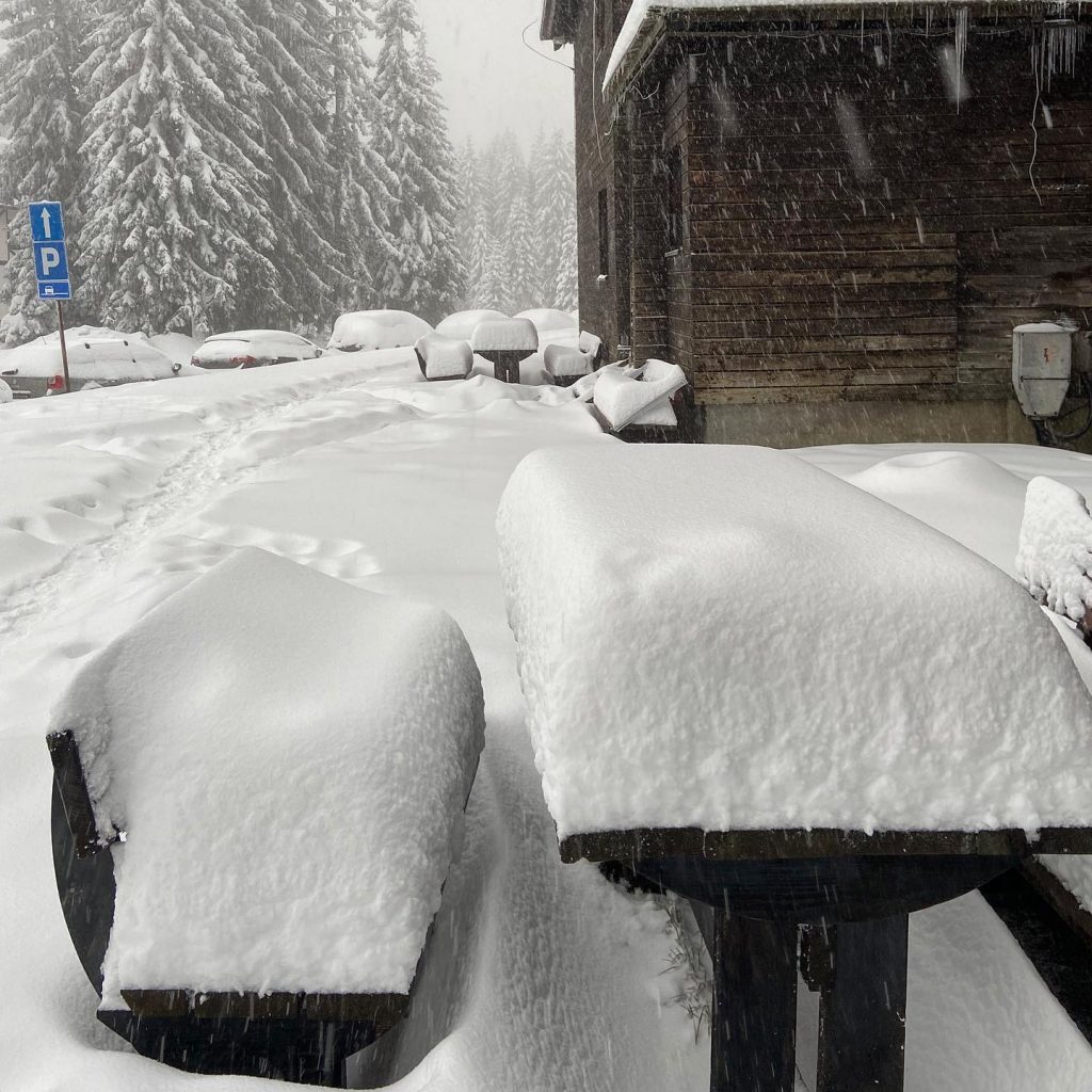
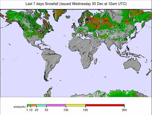
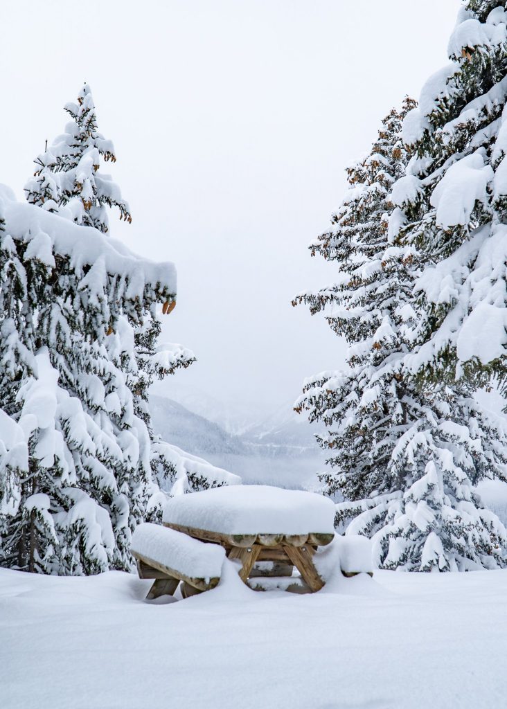
It has been a good week for snowfall for much of Europe with significant accumulations, up to a metre (40 inches) in fact reported for some areas. The snowfall has also been widespread with big dumps for the Dolomites, Pyrenees and Alps. Eastern European ski areas as well as those in Scandinavia, and to a lesser extent Scotland, have also seen much-needed snowfall with temperatures staying low. The only real issue has been gale force winds driving the snow in at times in some areas, closing centres for a day or two in both the Alps and Pyrenees at the start of this week.
The picture with the pandemic, in contrast, remains less positive and complicated. If anything, it is more complicated than it was a week ago. Austrian ski areas have now re-opened, but the country has gone into a new three-week lockdown, though ski areas can stay open. Andorran, French and Italian ski areas hoped to open in the first week of 2021 but that’s yet to be confirmed and Czech and Slovenian ski areas that had opened have now been closed again. Elsewhere, operating restrictions are typically getting tougher, leading to a ski area closure in Scotland, for example, but most others are staying open so far.
AUSTRIA
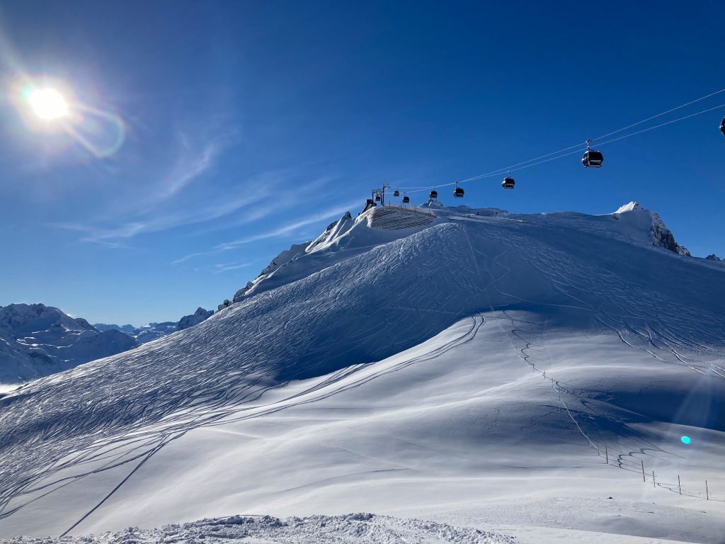
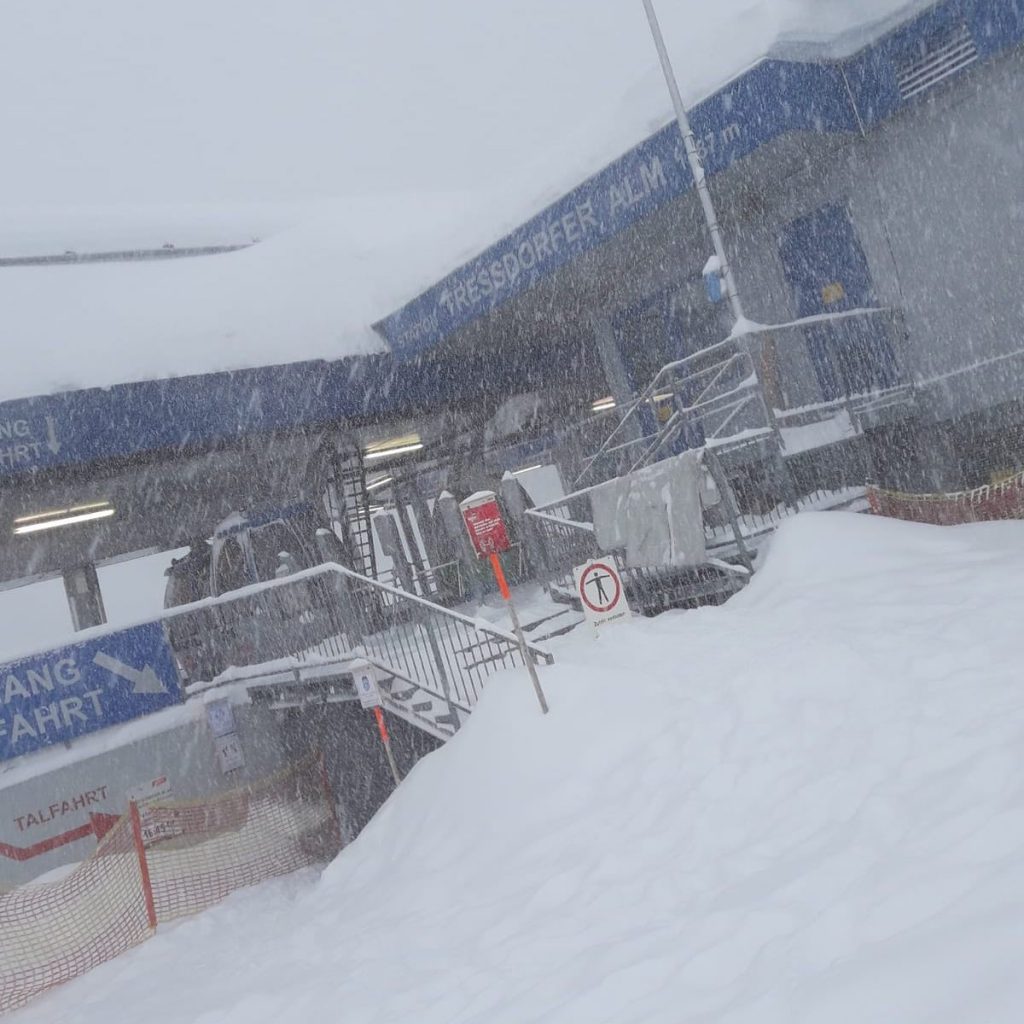
AUSTRIA REPORT| Austria’s main ski season is underway with resorts reporting incredible conditions, with fresh snowfall just as the season got underway from Christmas Eve. Most areas reported 10-30cm (4-12 inches) of fresh snow to start the season. Initially, the slopes are only open to locals, with tourists allowed from 7th January. Of course, 10 Austrian ski areas were already open back in the autumn when the country entered its second lockdown. These mostly included the country’s glacier areas and they have re-opened with at least a metre (40 inches) more snow lying than they closed with pre-lockdown. The news isn’t all good though, stormy weather to start the week closed some areas on Sunday/Monday and on Sunday the Molltal glacier (160/350cm / 64/140″) announced, without giving a reason other than “a difficult situation”, it was temporarily closing again at short notice. This led to speculation that it was getting very little business and could not afford to cover its operating costs from limited income. It was reporting the deepest base in the country upon re-opening. That accolade now goes to Hintertux (70/335cm / 28/134”) in terms of open areas. There was more snowfall and stormy weather for many areas on Monday, with World Cup Giant Slalom races at Semmering seeing the second run cancelled after the first went ahead, as winds strengthened to very strong gusts, but the sunshine has returned now.
AUSTRIA FORECAST| Staying cold as we enter 2021 with mostly dry weather until the weekend when snowfall is forecast for Saturday and Sunday. Temperatures should stay below freezing day and night, in the valleys as well as upon the slopes, for most Austrian ski areas.
SWITZERLAND
SWITZERLAND REPORT| Most Swiss ski areas remain open despite many measures from the country’s national and regional; governments limiting the risk of virus transmission. Most recently, Valais has closed restaurants, meaning skiers can now do little but ski then go to their accommodation when not on the slopes. One of the few ski areas in the country that had been forced to close over Christmas due to a decision by its canton’s government, Andermatt (50/310cm / 20/124”), has now been allowed to re-open.
SWITZERLAND FORECAST| Following the light snowfall of recent days it is looking like it will stay cold, but for most Swiss areas it will be dry over the remainder of this week. Temperatures should be subzero night and day with a mixture of sunshine and cloud, with the next snowfall expected in the latter half of the weekend for most.
FRANCE
FRANCE REPORT| French ski resorts are open but ski lifts are possibly closed until January 7th, although that date is yet to be finally agreed. Resorts are doing their best to make things appealing for first Christmas and now New Year guests but report tourist numbers down 80-90% creating challenging times economically. Some have nursery slopes open for children and several have groomed runs for those who want to hike up then ski down. As to the weather conditions, it has turned snowy since the weekend with temperatures below freezing and snow falling daily.
FRANCE FORECAST| The snowy weather in the French Alps should continue for the rest of this week with 10-40cm (4-16″) of snowfall likely by the end of Friday and temperatures staying well below freezing.
ITALY
ITALY REPORT| Italy has been the centre for World Cup racing over the past few weeks, giving us all a view of what conditions are like through our TV screens, even though the slopes remain closed to everyone but the world’s best racers. The latest competition was at Bormio with the initially planned downhill race on Monday switched with the GS on Tuesday due to the weather forecast, then the GS was postponed as very heavy snow rolled in with reports of up to a metre of snow falling. There were much better conditions and great fresh snow from Tuesday. Italian ski areas have been hoping to open from January 7th but there have been warnings that a lack of confirmation on that from the government there makes that target date less likely as the days go by.
ITALY FORECAST| Staying cold for the coming week with temperatures not likely to rise above freezing and more typically 5 to 15 degrees below right down to resort level across the country’s ski regions. Snowfall is forecast from Friday to Sunday over a wide area. All this means that if ski areas can open next week conditions are looking superb.
GERMANY
GERMANY REPORT| Germany has had a snowy start to the week with the biathlon competition at Ruhpolding on Monday impacted by heavy snow and, with the country’s ski areas officially closed by the government, managers at Winterberg asking people to avoid their slopes as huge queues of traffic built up as people headed to the ski centre to enjoy the snow even with the lifts not running. The start of the German ski season is currently set for 11th January.
GERMANY FORECAST| After the snowy start to the week, it is looking mostly dry for the first week of the new year for most German ski areas. Temperatures should stay cold and well below freezing with a mixture of sunshine and cloudy weather.
SCANDINAVIA
SCANDINAVIA REPORT| The snow conditions continue to improve across Scandinavia where the short midwinter daylight hours are gradually lengthening (or getting close to returning in the very far north). Some centres have posted up to 30cm (a foot) of snowfall in just the past few days. Of the bigger resorts, Sweden’s Are (35/49cm / 14/20”) has about half of its 90 or so trails open. The snow is deeper over the border in Norway where Hemsedal (115/115cm / 46/46”) has 40 of its 50 runs open.
SCANDINAVIA FORECAST| It’s going to be cold, thankfully, over the week ahead with temperatures typically 5-15 degrees below freezing night and day. After some midweek snowfall though it will be predominantly dry now over the coming week with just occasional light snowfalls expected.
SCOTLAND
SCOTLAND REPORT| Scotland has gone into a three week ‘near lockdown’ with all of the mainland moved into the highest tier (4) in a bid to prevent the virus spreading. As a result, ski areas can only open to people living near therm. Cairngorm has decided to close altogether for the duration, joining Nevis Range, but three centres, Glenshee, Glencoe and The Lecht, remain open. After a warm, wet end to last week, it has turned colder and snowier so conditions are improving at the three but so far they only have very limited terrain open for those lucky enough to live nearby and able to ski it.
SCOTLAND FORECAST| The next week is looking predominantly cold and sometimes snowy on Scottish hills so things should continue to improve on the slopes there.
SPAIN / ANDORRA
SPAIN / ANDORRA REPORT| The Pyrenees have, like the Alps, been seeing a period of heavy snowfall in recent days; however apparent good news that ski areas in Andorra may be able to open from January 2nd (this Saturday according to reports from the principality), have sadly not been confirmed by ski areas there as of 30th December. They say they’re still waiting to hear. Currently, however, only some Spanish ski areas remain open. They include the biggest, Baqueira Beret (50/70vcm / 20/28”) with around 40km (25 miles) of runs open. Sierra Nevada (30/100cm / 12/40”) with 50km (31 miles) of runs open at present is also operating, although it was closed by strong winds on Tuesday.
SPAIN / ANDORRA FORECAST| The current cold and snowy weather in the Pyrenees is expected to continue through to the start of the new year on Friday with snowfall daily. From the weekend things should quieten down a little but stay cold with overcast skies.
BULGARIA / ROMANIA REPORT
BULGARIA / ROMANIA REPORT| It is a constantly improving picture at present in the southeastern ski nations of Europe with more ski areas opening and those that were already open adding more terrain. That’s largely thanks to low temperatures for snow-making and a lot of natural snowfall over the past week. The biggest, Bansko (0/75cm / 0/30”), now has more than half of its 50km of slopes open and Borovets (15/30cm / 6/12”) is the latest of Bulgaria’s ski areas to open for the season at the weekend. Pamporovo (20/90cm / 8/36”) has the deepest base.
BULGARIA / ROMANIA FORECAST| A mostly sunny week ahead although with a band of snowfall expected on Thursday and potentially another on Sunday. Temperatures staying low down towards -3 to -8 below freezing on the ski slopes but getting up above freezing down in the valleys in the afternoons.
CZECH REPUBLIC / SLOVAKIA
CZECH REPUBLIC / SLOVAKIA REPORT| Ski areas in the Czech Republic are currently closed due to pandemic restrictions. But those in Slovakia are staying open so far, with fresh snow falling over the Christmas weekend and the start of this week. At least about half of the country’s ski areas have opened so far with half still closed perhaps due to the costs of operating in a pandemic, perhaps low snow cover too. Jasna (40/80cm / 16/32″) has about a quarter of its terrain open and twice the snow depth of its nearest competitor.
CZECH REPUBLIC / SLOVAKIA FORECAST| It should be a cold and snowy end to the year with fresh snowfall forecast on Wednesday/Thursday and temperatures well below freezing. The start of 2021 should dawn sunny but with temperatures staying low.
NORTH AMERICA
It’s continuing to improve in the Rockies with more fresh snow falling taking resorts closer to their seasonal norms at this point and enabling them to open more terrain. Not huge snowfalls so far but significant still with Breckenridge (30/30” / 74/74cm) for example, posting 11 inches (28cm) of snowfall over the weekend and start of this week and now having around half its terrain open. It has been snowing almost everywhere in the region though with some areas in southern Colorado as well as up in Utah posting as much as 20 inches (50cm) of snowfall in the same period. As a result, more and more terrain is opening up.NORTH AMERICA INTRO| It’s a largely improving picture across North America where some regions have had below average snow cover up to now. The northwest of the continent, particularly around the Alberta/BC border in western Canada, continues to see the best conditions arguably of anywhere in the world, at present. Bases are building towards the 5 metre (17 feet) mark at several areas after still more snowfall there. The Rockies, in the US to the south, have had more snow too, as have the Sierras to the west and parts of the Midwest on the other side. The only real ‘hiccup’ for Christmas week came in the northeast of the continent when a warm few days brought slope-damaging rain to parts of the region as far north as Quebec, closing some areas at the start of this week, before things turned colder and snowier once more.
The pandemic continues to be a big issue. There’s been shock in Ontario where the provinces 40+ ski centres have been ordered to close. Everywhere else in the continent centres are open though, but in many cases just the lifts, with mountain dining closed and strict limits on skier numbers, which has caused many bigger areas to sell out of lift tickets over these peak periods.
ROCKIES
ROCKIES REPORT| It has been a snowy week in the Rockies after the rather warm and dry autumn, greatly improving conditions and leading resorts to open up much more terrain. Some have reported as much as two feet (60cm) of fresh snowfall in the past seven days. Along with the good news that more can open, the bad news has been an increasing avalanche danger with The Colorado Avalanche Information Center saying more than 300 avalanches have been reported in the past week, about a third of them human triggered. Two, sadly, caused fatalities (one of two skiers), the other, Crested Butte ski patroller and prolific backcountry skier Jeff Schneider. The Colorado Avalanche Information Center warn of the most unstable snowpack since 2012 at present due to climatic and snow conditions and variations in recent weeks and months. Wolf Creek Ski Area (62/76” / 155/191cm), which was the first ski area in the west to open for the 21-22 season two months ago now, is posting the region’s deepest base.
ROCKIES FORECAST| Following the snowfall at the start of this week it is looking sunny in the Rockies for at least the next seven days. Cold though with temperatures typically in the range of 10 to 20 degrees below freezing, which should help keep the fresh powder snow in good condition.
USA WEST
USA WEST REPORT| Largely good news for the US West with snow as far south as southern California and more snow in the Sierras and further north in Oregon and Washington state where several resorts now have more than seven feet (two metres) of snow lying. It’s not all perfect ski weather though, with occasional wet and windy spells hitting the region. Mammoth (23/39” / 58/97cm) got another five inches (13cm) of snowfall on Monday and has about half of its runs open. Some areas are choosing not to open more terrain, although they could. The decision is down to limited numbers able to access slopes.
USA WEST FORECAST| A largely cold week forecast with more fronts bringing more snow into most areas as we enter 2021. A rapidly changing forecast with periods of snowfall possible most days really.
USA MIDWEST REPORT
MIDWEST REPORT| The Midwest saw some of its coldest temperatures and best snowfalls of the winter so far over the Christmas period with some centres reporting more than 20 inches (50cm) of snowfall. As a result, almost all of the ski areas in the region are now open, with Welch Village (15/46″ / 38/114cm), in Minnesota, posting the deepest base with Indianhead (17/19” / 46/48cm) posting some of the biggest snowfalls of the past few days, although most areas posted at least 4-12 inches (10-30cm).
MIDWEST FORECAST| It should remain very cold over the coming week with temperatures 5-20 degrees below freezing for much of the time at most Midwestern ski resorts. There’s not much precipitation in the forecast; Wednesday/Thursday for most areas and temperatures could creep back up to freezing by Sunday, but it’s a largely dry picture.
USA EAST
USA EAST REPORT| It has been an often challenging week in the east with the forecast of warm weather at the end of last week bringing a shock to the snow cover and unfortunately heavy rain for many areas. This weather damaged the snow and led to some temporary ski area closures. The worst consequence was a wet snow avalanche which crashed into the base lodge at Belleayre ski area in New York state. But for most areas, it has been an improving picture since the start of this week though with colder temperatures and some fresh snowfall too in the past 48 hours. Blue Mountain Resort (24/48 / 61/122cm), in Pennsylvania, is posting the deepest base in the region but Stowe (12/36” / 30/90cm) has by far the most snowfall reported, eight inches (24cm) since Sunday.
USA EAST FORECAST| There should hopefully be no repeat of the rain with predominantly dry, cold weather in the forecast. The only slight concern is Saturday 2nd when temperatures should rise to (hopefully) a degree or two above freezing as a front moves across, but this should bring some snow again, not rain.
CANADA
CANADA WEST
CANADA WEST REPORT| Western Canada continues to post some of the world’s best snow conditions and the deepest snowpack. Sunshine (144/469cm / 57/188”), near Banff in Alberta, has overtaken Kicking Horse (181/426cm / 72/171”), in BC, for the deepest base globally so far this season; however, both resorts have added substantially to their bases compared to seven days ago after more heavy snowfall, particularly at the end of last week over Christmas. It has been quieter since with the last reported snowfall on Sunday but temperatures still very cold.
CANADA WEST FORECAST| Remaining dry, but overcast in most areas, for the rest of this week. Temperatures staying cold, typically 10 to 20 degrees below freezing. Snowfall should return at the weekend with 10-30cm (40-12 inches) over Saturday/Sunday before drier conditions begin and some sunshine from next Monday.
CANADA EAST
CANADA EAST REPORT| The big news from Eastern Canada this week was, unfortunately, the decision by Ontario’s provincial government to shut down ski areas there. So far, at time of writing, the only area in North America to take that step. In further bad news for eastern Canada, the forecast heavy Christmas rain, worst in the south of Quebec, led to damage to the snowpack and closures from Sunday of some of the ski areas there. It has been snowing again in the past 48 hours though, helping get the season back on track.
CANADA EAST FORECAST| After the unwelcome warm snap at the end of last week, it is looking much more like a normal January in Quebec over the coming week with very cold temperatures the norm (up to 20 degrees below freezing) and sunny or snowy weather. So far the latter half of this week is looking snowier than the weekend and start of next week. 10-20cm (4-8 inches) of snowfall is forecast over Thursday/Friday.
ASIA
JAPAN REPORT| After the big snowfalls in the run-up to Christmas, unfortunately it has been warmer and drier at most Japanese ski regions over the past week. The drier weather is probably good news really under the circumstances. Temperatures crept up a few degrees above freezing meaning some of the limited precipitation there has fallen as rain at some resorts in the valleys, snow higher up. Things are changing though with a major multi-day snowstorm moving in from Tuesday evening and set to last into the new year. Niseko (125/225cm / 50/90”) reports 60cm (two feet) of snow in the past week.
JAPAN FORECAST| Heavy snowfall is forecast to continue on Japanese slopes through to the weekend. This could be accompanied by very low temperatures and with some wild weather at times plus some big accumulations likely in many areas. Calmer for most from Saturday.


