WORLD SNOW ROUNDUP #125
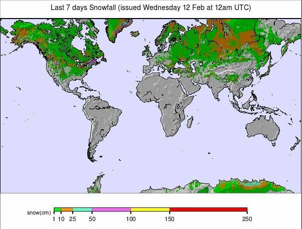
Issued: 12 February 2020
By Patrick “Snowhunter” Thorne
North American Roundup
European Roundup
Asia Roundup
INTRODUCTION NORTH AMERICA
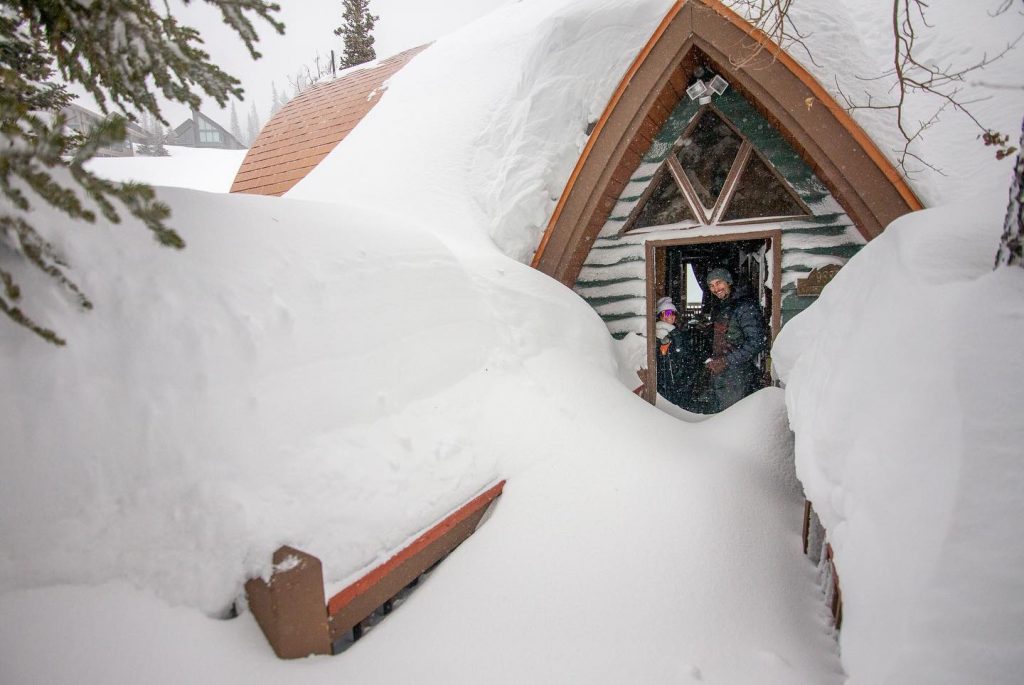
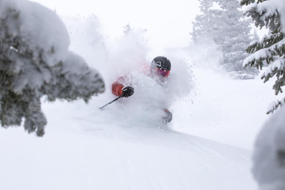
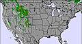
Although it has kept dumping down for a sixth (or is it seventh?) week in the Pacific Northwest the big snow news story of the last seven days in North America has probably been the huge snowfalls in the Rockies. The storm has brought deep powder but also, in the short term, lots of less welcome factors like access roads closed by too much snow and avalanche danger. Lifts and runs closed for similar reasons have led to huge queues at some of the lifts that remain open and a few other problems. As the snowfall has eased now the week ahead looks great.
There have also been some good snowfalls for the east, both north and south of the border and particularly welcomed in Quebec, which had been struggling with poor snowfalls to date. The province now sees an increasing number of its ski areas finally able to fully open their slopes.
USA
ROCKIES
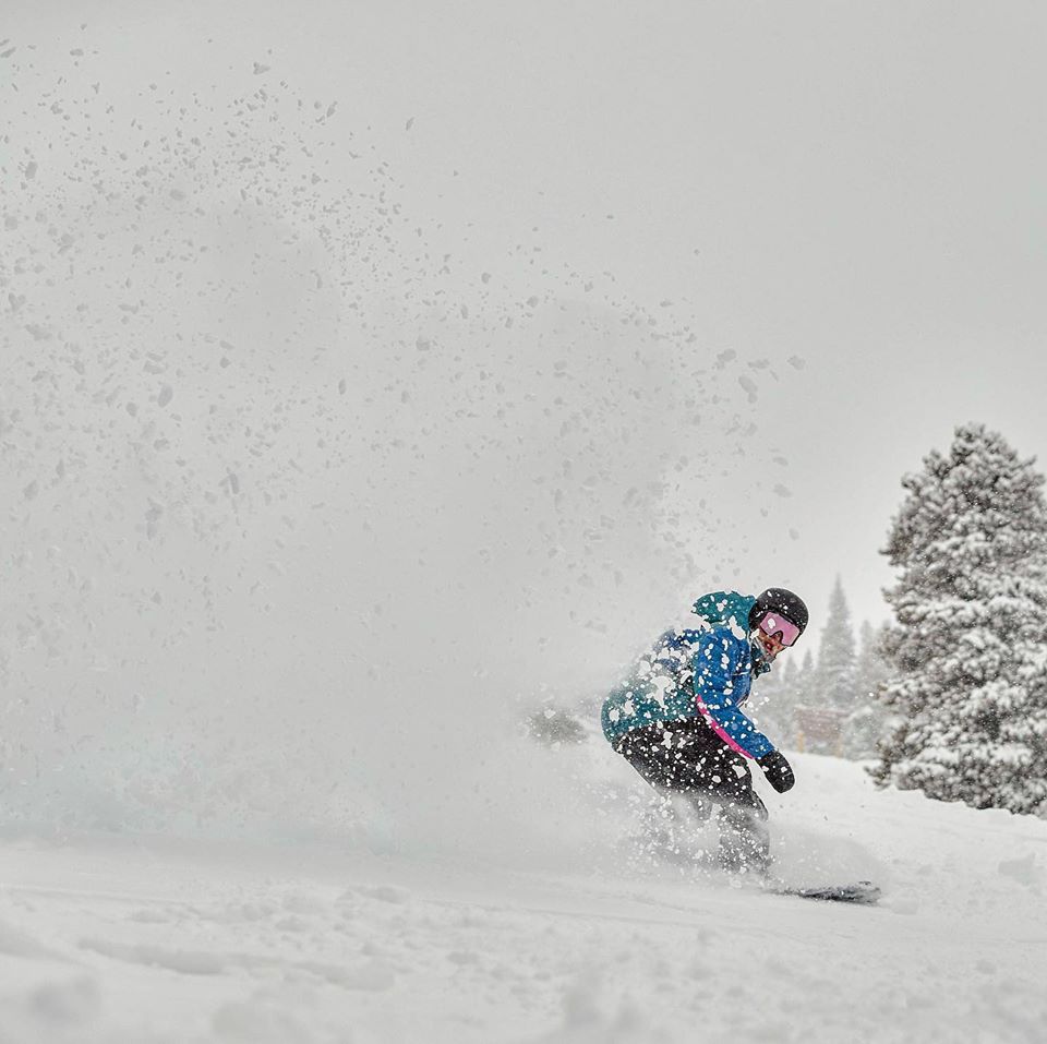
ROCKIES REPORT It’s been one of the snowiest weeks of the season so far in the Rockies bringing epic powder but also some practical problems at times. Up to 5 feet (150cm) of snowfall was reported at some resorts. Avalanches (or the threat of them) caused closure on the main I 70 from Denver out to Colorado’s resorts and in Utah, out to little Cottonwood Canyon at the end of last week. This limited access to Alta (126/126” / 315/315cm) and Snowbird (125/125” / 312/312cm), which already had the deepest snow in the region. Loveland (73/73” / 183/183cm) was also closed at the end of last week by snowstorm related issues. Other factors included huge lift queues at Vail (images of which went viral) as they struggled to cope with demand vs the amount of terrain they could safely open and a tree well death at Steamboat. Loveland, along with Breckenridge (85/85” / 213/213cm) reported some of the biggest 72-hour snowfalls with 4 feet (120cm) each. The snowfall had eased off by the start of this week but light snowfall was still being reported.
ROCKIES FORECAST A mixture of sunshine and snow showers in much of the Rockies region over the week ahead with temperatures hovering around, or a little below, freezing. It shouldn’t be as snowy as the past four or five days but some periods of light to moderate snowfall are forecast with heavier snow likely going into the weekend.
WEST
USA WEST REPORT Despite the huge snowfalls in the Rockies this past week, the Pacific Northwest and particularly Alpental ski area in Washington state (90/207” / 226/518cm), have once again topped North America’s snowfall table as they have every week since Christmas. After another 183cm (6 feet) of snowfall in the past week, Alpental is the only ski area in the world posting a 5 metre plus base this week. There continue to be problems caused by warm temperatures at times though and access to another Washington-state ski area, Bluewood (77/85” / 192/213cm) was cut off by floods in the region at the weekend. There has also been an issue with strong winds with Kirkwood, in California, closed by very strong gales on Sunday.
USA WEST FORECAST Perhaps not quite such a snowy week ahead as the last one. A mixture of sunshine, cloudy and snowy days coming up with some days seeing as much as a foot (30cm) of snow at some areas but generally less on the odd day rather than non-stop. Temperatures are looking like they should stay below freezing though.
MIDWEST
MIDWEST REPORT It has been a pretty good week for skiing in the Midwest with temperatures staying fairly cold and many areas reporting some good natural snowfalls. Many ski areas in Michigan, for example, reported 4-8 inches (10-20cm) of fresh snowfall in the past 72 hours, including Shanty creek (60/60”/ 152/152cm) which has one of the deepest bases in the region.
MIDWEST FORECAST It’s mostly cloudy but dry across the Midwest at present. Temperatures should stay sub-zero at most areas through the week ahead, allowing for more snow-making as required. The next natural snowfall is expected early next week.
EAST
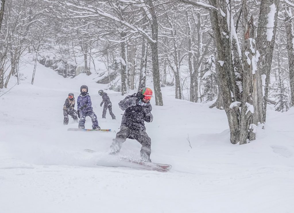
USA EAST REPORT There continues to be something of a north-south split in the east, as there has been most of the winter so far. So it has been a snowy few days in large parts of the east US with resorts reporting great conditions thanks to several inches of fresh snowfall on the slopes. But that’s in the north in states like Maine, Vermont and New York. Further south in Massachusetts its been raining again. Stowe (36/61” / 91/152cm) continues to post the best snow depth numbers in the region and has all of its 110+ ski slopes open.
USA EAST FORECAST We’re looking at more snowy weather for the next few days for ski areas in the east and temperatures staying well below freezing, down to 20 degrees below at times. Snowfall will most likely be moderate rather than heavy and then clear towards the end of the week when a mix of sunshine and cloud will be the norm.
CANADA
WEST
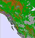
CANADA WEST REPORT It’s still snowing in western Canada and conditions could hardly be better across most of the area. Along with the fresh snow, bases keep building with Big White (231/330cm / 92/132”) being one of several BC areas to pass the 3 metre/10 foot base depth marker in the past few days. The volume of snowfall does mean the avalanche danger is high in some areas with Apex one of several warning backcountry skiers to be sure to check reports and behave responsibly before heading out.
CANADA WEST FORECAST A mixture of sunshine and snowfall in Canada’s west over the week ahead with temperatures set to stay solidly below freezing, usually just a few degrees but sometimes double-digits below. Bands of snowfall will move across the region every 24 hours or so, bringing 20-40cm of snowfall in total by the start of next week to the eastern side of the region. There’ll be heavier snowfall once again, particularly from Thursday on, on the west.
EAST
CANADA EAST REPORT Quebec has probably had its best weekend of the ski season so far with cold, snowy weather since Friday bringing some good accumulations to the province which has been struggling from periods of warm temperatures and lack of snowfall all winter to date. Ski areas here have reported 10-40cm (4-16 inches) of snowfall over the weekend which has transformed conditions and means most of the region’s larger ski areas are fully open for the first time this season. Mont Sainte Anne (43/63cm / 17/25”), one of those that had been particularly suffering up to now, reported 30cm (a foot) of snow and that all 70+ runs are now open and all lifts operating.
CANADA EAST FORECAST It should stay wintery, although with less snowfall, for the coming week in eastern Canada. Temperatures are expected to be much closer to seasonal averages, well below freezing (potentially as much as 20 below at times in fact), with light snow flurries and some sunny days. The end of the week is likely to be the sunniest with heavier snowfall returning at the end of the weekend.
INTRODUCTION EUROPE
After a sunny weekend in the Alps, it has been snowy since Monday and looks likely to stay that way for many areas right through the week, with temperatures staying low for most too.
Alas, that’s not good news as a storm system named Sabine in German-speaking areas and Ciara further west, has brought storm-force winds with it that has closed upper slopes in many areas over the past few days, everthing in some more exposed centres; however, once it blows through, things are looking good with more fresh snow to enjoy.
Elsewhere in Europe, it’s been drier in the Pyrenees but a little warm too; however, bases are still good so everything is open. A similar picture in the Dolomites and southern Alps which are missing out on the bigger snowfalls but getting some of the strong winds at present.
Eastern European areas are enjoying some of the best conditions of the season so far after cooler temperatures and fresh snowfall there since the start of this month. It’s also been snowing in Scotland and Scandinavia (a lot in western Norway again), although here too strong winds are causing lift closures at times.
AUSTRIA

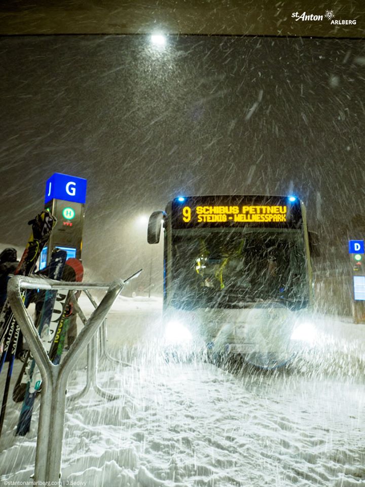
AUSTRIA REPORT After a sunny weekend across much of Austria it has been snowing again since Monday. The snowfall is expected to continue to the end of Wednesday or into Thursday at some resorts. 20-40cm (8-16 inches) of snowfall is expected for many areas by the time the latest storm ends and the skies clear once again; however, it looks like after a day or two of clear weather at the end of the week more snow-bearing clouds will move into the weekend meaning some areas may see a metre (40 inches) of snowfall in total by the start of next week. In the more optimistic scenario. St Anton am Arlberg (100285cm / 40/114”) and its neighbours is one of those with potential to see a lot of snowfall. The country’s glaciers continue to report good snow depths with the snow lying more than three metres (ten feet) deep on six of them.
AUSTRIA FORECAST As mentioned in the report, the snow that has been falling since Monday in much of Austria is continuing to fall at present and is set to continue at most Austrian resorts at least to next Sunday and probably beyond. February continues to be a much snowier month than January in the country. It is generally colder too with most resorts at about 1000 metres altitude likely to see temperatures remain below freezing for the coming week. The deepest snow continues to be up on the country’s glaciers where six of the eight report more than three metres (ten feet) of snow is now lying, but some of these were also closed on Monday as storm Sabine (as it was named there) blew through.
SWITZERLAND

SWITZERLAND REPORT After a clear and sunny end to last week across most of Switzerland it’s been snowing again since Monday. Like many resorts across the Alps, and similar to the snowstorms of the past two weeks, several resorts have closed high altitude terrain and sometimes their whole ski area, due in particular to storm-force winds. Laax and Verbier were among areas warning their slopes were partially closed on Monday and Tuesday. But the snowfall, which is set in for the week in most resorts, has already brought 20-40cm (8-18 inches) of fresh snow to many areas again and bases are building once again. Andermatt (40/410cm / 16/164”) is still posting the deepest base in Europe at the time of writing this roundup.
SWITZERLAND FORECAST It’s a snowy week right across Switzerland with temperatures staying cold too. Current forecasts show light to moderate snowfall through to the end of Wednesday, a clear sunny day for some areas in the east of the country on Thursday then heavy snow Friday and again from Sunday. In the west, the snowfall is more constant with heavy snow through to Friday, but possibly a clear day on Saturday for some here. It looks like quite a few areas might get more than a metre (40 inches) of snowfall in total by the start of next week.
FRANCE
FRANCE REPORT We’re in an unsettled spell of weather in the French Alps with stormy conditions from storm Ciara closing some areas on Monday and then heavy snowfall on Tuesday across much of the French Alps again both closing slopes and further improving conditions at the same time (in terms of snow depth and fresh cover). La Plagne (125/285cm / 50/114”) and the wider Paradiski region was one of the first to see significant snowfall at the start of this week with 15cm (6 inches) into Monday before the storm intensified. It also currently has the deepest snow lying in France on its upper slopes. It seems likely several French areas will go through the three-metre/ten feet mark by the weekend.
FRANCE FORECAST After the heavy snowfall on Tuesday, there’s lighter snowfall expected through Wednesday and in some places (including the 3 Valleys) it’s expected to continue into Thursday. That may not be the end of it either with another band of heavier snowfall expected to arrive at the end of the week so we may be looking at more than a metre (40 inches) more snowfall in total this week for some areas if all plays out as presently forecast.
ITALY

ITALY REPORT Mixed conditions in recent days acrossItalian mountain regions with some light snowfall, some cloudy dry days and some areas getting full sunshine, and most areas getting all three at one point or another. Most of the country has not seen so much snowfall as in the northern Alps but there has still been some snowfall, again mostly along the country’s northern and western borders; just a few centimetres again this week in many areas elsewhere. Strong winds have been felt across Italy too with the Sella Ronda closed at the start of this week as the sorm blew through the Dolomites. Otherwise, as has been the case all winter so far in Italy, on-slope conditions remain pretty good. Earlier snowfalls have helped here with most higher resorts fully open with good base depths, especially on upper runs. It has stayed mostly cold this week too, only getting above freezing for limited periods in the valleys. Madesimo (120/300cm / 48/120”) is posting the deepest base of Italy’s bigger resorts.
ITALY FORECAST A mixed forecast for Italy with some very heavy snowfall forecast for one area, the northwest corner, much as it has been for the past three weeks. Little snow elsewhere, just a few centimetres/inches for most of the rest of the country’s mountains, if anything. But it’s looking like almost constant heavy snow for resorts like Courmayeur, La Thuile and Cervinia up in and near the Aosta Valley. The tap seems to get turned off a little further south in Via Lattea, for example, if the forecast deluge area border proves spot-on accurate.
SCANDINAVIA

SCANDINAVIA REPORT There’s been heavy snowfall in Norway again (the story of 2020 so far…). Up to 35cm (14”) has been falling on western slopes in the country over the last 24 hours with Myrkdalen by Voss reporting another 70cm (28”) in the first 72 hours of this week. Roldal (160/ 250cm / 64/100”) got another 50cm (20 inches) in the same period and has further increased its position as having the deepest snow in Scandinavia, by some distance, this winter; however, strong winds have been an issue at times, as elsewhere in Europe. Elsewhere, the pattern of fairly good snow on northern, western and central mountains continues, less good still in the south. Bjorkliden, in Sweden’s Arctic north, opened for its 2020 ski season at the weekend and it’s due to be joined by Riksgransen later this month. The reports state that the snow is the deepest it has been there at this time of year since the 1990s.
SCANDINAVIA FORECAST There’s really not a lot of change in sight in the forecast with still more big snowfalls forecast for Norway over the next week. There may be a bit of a lull up to the weekend then potentially another 60cm (two feet) plus over the weekend in the west again Temperatures should stay just below freezing most of the time.
GERMANY

GERMANY REPORT German ski areas are continuing to improve against the backdrop of a fairly dire season for many areas with temperatures too warm too often, especially impacting the country’s many smaller, lower ski hills. It was snowy until Thursday/Friday last week before a generally sunny weekend when temperatures got a little too warm again. But since Monday we’ve been back to sub-zero generally and we’re now in the middle of a fresh snowstorm expected to deposit 20-40cm (8-16 inches) on many areas. Balderschwang (60/70cm / 24/38”) is one of those expecting a bigger snowfall. The Zugspitze Glacier (264/330cm / 105/132”), Germany’s highest area, posted one of the biggest snowfalls in Europe over the past week with 120cm (four feet) of fresh snow.
GERMANY FORECAST The current snowfall in Germany should continue through to the end of Wednesday and into Thursday after which drier weather is expected. Further snow is forecast for some areas on Friday. Temperatures should vary between a few degrees above freezing and more often sub-zero temps, sometimes as low as double digits below freezing. This means that there should not be too much of a thaw over the coming week.
BULGARIA and ROMANIA
BULGARIA / ROMANIA REPORT It’s been one of the best weeks of the season so far in Bulgaria, with plenty of fresh snowfall and low temperatures allowing most of the country’s areas to fully open at last. Pamporovo (200/200cm / 80/80”) has the deepest snow in the region and about 75% of runs and lifts open.
BULGARIA / ROMANIA FORECAST Temperatures have been hovering around freezing for the past week and will continue at around that point for the week ahead, at least until the weekend when they may rise a few degrees above, particularly in the valley. Light snowfall is forecast for Wednesday/Thursday after which clear skies should be the norm.
CZECH REPUBLIC and SLOVAKIA
CZECH REPUBLIC / SLOVAKIA REPORT A mixed picture in the Czech and Slovak Republics in recent days with some fresh snow on higher slopes but also rain reported on lower runs. As usual it’s the bigger ski areas that look to be in the best shape, including Jasna (30/70cm / 12/28”) which reports its slopes to be 95% open (just a couple of black runs with inadequate cover).
CZECH REPUBLIC / SLOVAKIA FORECAST After the snowfall and some rain it is now a fairly dry picture in the Czech and Slovak Republics. With temperatures staying cold and below freezing snow conditions should be good for the week ahead.
SPAIN and ANDORRA
SPAIN / ANDORRA REPORT There’s less active weather to report in the Pyrenees, than in most of the rest of Europe, with the third week of generally clear, sunny weather. With just a little light snowfall coming in at present there is only likely to be a few centimetres (an inch or two) added to the existing cover. The good news is that thanks to big snowfalls last month and during December, between the long sunny, warmer-than-we’d-like spells, the cover got to a decent depth. This means that, even with a little thawing, most of the region’s bigger, higher ski areas remain fully open. Grandvalira (50/150cm / 20/60”), the biggest, reports all 120 runs open, adding up to 210km of slopes with all 60+ lifts turning.
SPAIN / ANDORRA FORECAST The current light snowfall in the Pyrenees should wind up by the end of Thursday and then we return to clear skies and sunshine through into the weekend. Unfortunately, it will continue to be rather too warm for the time of year, generally just a few degrees above freezing, but potentially hitting double digits above freezing point in the valleys later in the weekend. No more snow in the forecast at present.
SCOTLAND

SCOTLAND REPORT Conditions do seem to be gradually improving on the Scottish hills but with a full-blown storm raging for the past five days and lifts shut down, it’s hard to be sure yet just what the situation is. There has been a lot of precipitation driven in on the strong winds but with temperatures generally above freezing this has mostly fallen as rain or sleet at lower elevations, although there appears to have been a good dump of hill snow higher up, particularly in the west. As it has done all year so far, Glencoe looks to have the most potential terrain to open with nearby Nevis Range also looking good. All five areas have their all-weather snow-making machines maintaining beginner areas.
SCOTLAND FORECAST It is looking a little too warm for comfort at the end of the week in the Scottish Highlands. That said, the weather situation is extremely volatile and changing by the hour, even the short-term forecast. Therefore, it may stay colder than currently seems likely and hopefully any snow that has built up in the recent storms will not be lost again. There’s also more snow in the forecast for high ground anyway as the unsettled conditions of the past few months looks set to continue for at least another week.
JAPAN
JAPAN REPORT Our friends atSnowJapan.com are excitedly reporting something like a normal Japanese winter at last, for large parts if not quite all of the country’s ski regions, over the past week. So temperatures closer to their normal double-digits below freezing and abundant snowfall arriving. They note that Myoko has done particularly well with a 1.2 metre (4 foot) snowfall over four days into the weekend. Niseko (120/260cm / 48/104”) reported nearer 60cm (two feet) of fresh cover but great conditions as a result there too now.
JAPAN FORECAST Despite the big improvement in the past week, unfortunately, it appears another warm spell is now on the cards for the next week with the snowfall slowing down and temperatures well above freezing again through the weekend; however, there does appear to be another spell of cold, snowy weather moving in from Sunday.


