WORLD SNOW ROUNDUP #115
Issued: 27 November 2019
By Patrick “Snowhunter” Thorne
INTRODUCTION
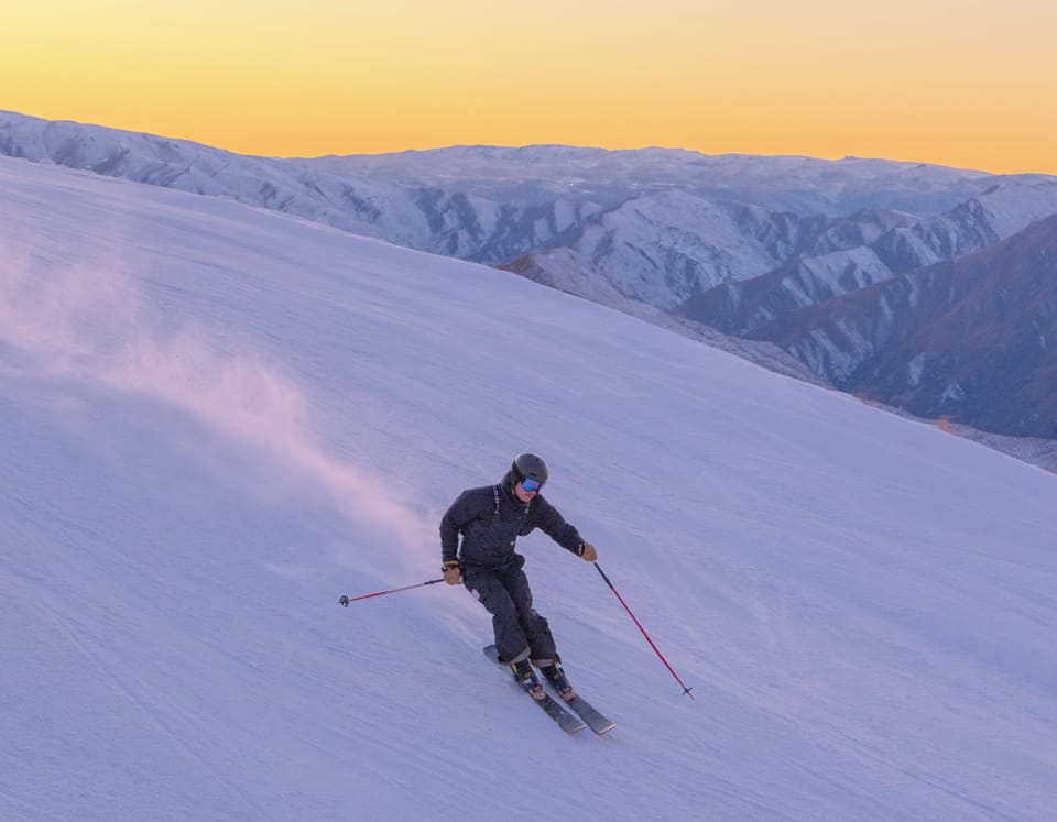
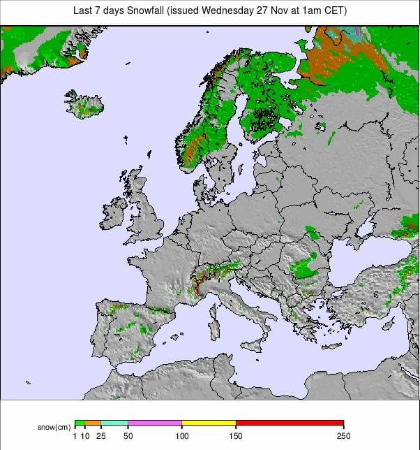
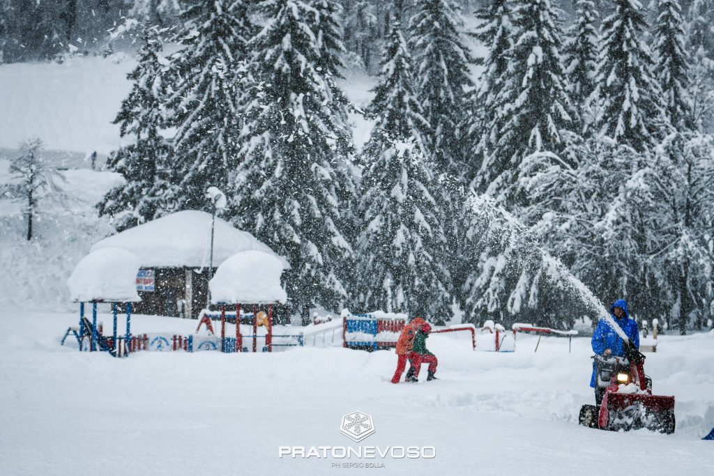
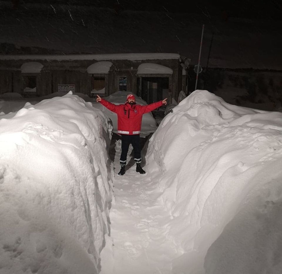
It has been another exceptionally snowy week in the Alps with much of the snowfall coming over the weekend, althou wfall was reported with the southern Alps along the French/Italian border seeing the heaviest snow. Some areas have now had more than 3 metres (10 feet) of snowfall this month with more to come in the final days of November. Along with the snowfall, there were strong winds in many areas, temporarily closing a lot of the resorts that have already opened and impacting the first day of the season for some resorts including Alpe d’Huez, Chamonix, Montgenevre and Val Thorens.
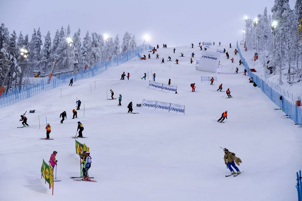
Elsewhere, there was more snow in Eastern Europe, the Dolomites and up in Scandinavia where it snowed right through the opening events of the 2019-20 FIS World Cup Slalom races in Levi, Finland. There was a little fresh snow in the Pyrenees too where ski areas in Andorra opened for the season as well as half-a-dozen of Spain’s biggest resorts.
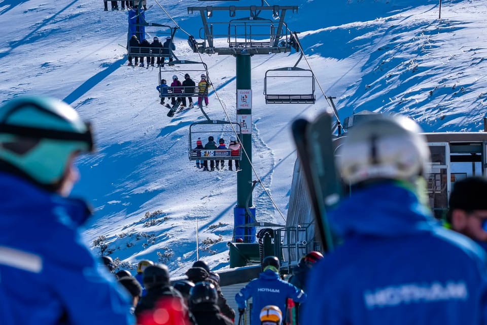
In North America, weather conditions have been more favourable than they have through all of November, in some areas, with 20-30cm of snowfall reported in snow-starved California as well as several other western states. The picture in the east has also got increasingly snowy. There’s a rush for as many ski areas as possible to open for the Thanksgiving long weekend and at the last count more than 80 had managed it with a number of other areas saying they’ll open on the day. So the US should be the first of the big ski nations to have more than 100 areas open for the 19-20 season by the coming weekend.
It’s much quieter in terms of resorts open so far in Canada but the first in BC, Sun Peaks, did open at the weekend and more small centres in the East in Quebec and Ontario.
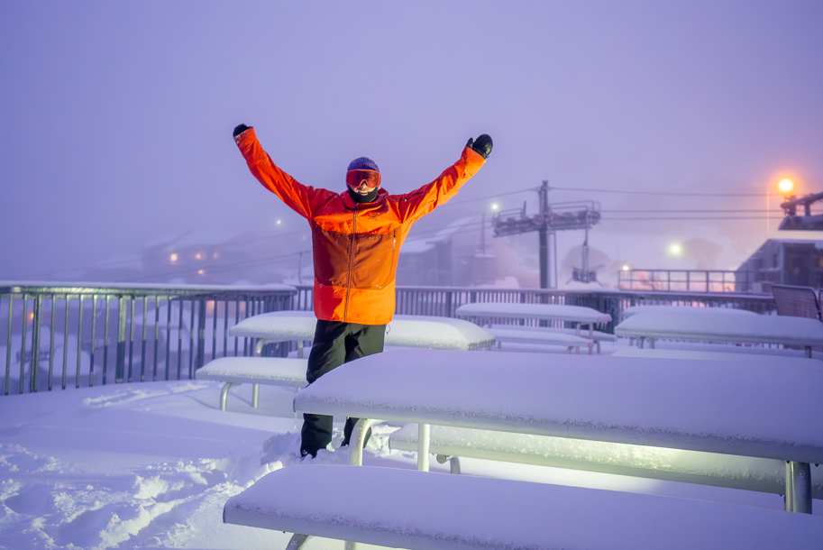
Elsewhere in the world Japan’s ski season got underway at several of the country’s leading resorts and the Southern Hemisphere’s 2019 ski season continues, with less than a week to go until the start of summertime there, at Whakapapa on Mt Ruapehu (on New Zealand’s North Island) which is opening one lift for four hours a day at weekends to access the remaining snow. The centre has announced this Sunday, December 1st will be the final day of the 2019 season.
INDEX:
Austria / France / Switzerland / Italy / Andorra / Norway/Sweden / Germany / Bulgaria / Japan / Scotland / USA / Canada / South America Weather Outlook / Southern Hemisphere / Europe Weather Outlook / North America Weather Outlook
AUSTRIA
Around 30 Austrian ski areas have now opened for 2019-20 season, after months of there just being the 8 or so glacier areas operational. Several resorts have opened early after the big snowfalls through November, the latest of which hit the country at the weekend, bringing 30-60cm more snow to higher slopes. Although accompanying strong winds also closed many areas on Saturday for safety reasons and the Stubai glacier had to cancel World Cup freestyle skiing too. All this snow means bases on higher slopes are looking good and glaciers that only had thin cover, and in some cases had to close with no cover in August/September, are looking good again. One of these was the Molltal Glacier (3200/290cm) which has reported 150cm (5 feet) of new snow in the past week and has the deepest base in the country. Hintertux (20/175cm) now has more than 50km of piste open and its full 1750 metre vertical.
FRANCE

French resorts have had some good snowfalls through November after the warm and dry September/October period, but initially not so much snow as further east in eastern Switzerland and Austria. That was rectified a little over the weekend with Tignes (65/150cm) and Montgenevre (60/100cm) posting some of the biggest snowfalls: 50-60cm of fresh. Besides these two, other French areas opening, some just for the weekend initially, included Alpe d’Huez, Chamonix, Puy St Vincent and Val Thorens whilst there were also two or three areas open down in the Pyrenees. More big-name resorts including Val d’Isere are set to open next weekend.
SWITZERLAND

Around 30 Swiss ski areas have now opened, although about half only at weekends, and another group are set to join them on Saturday. There was more heavy snowfall and storm-force winds at the weekend, which temporarily closed many areas. One example, Saas Fee (85/105cm), which reported one of the bigger falls, closed roads at the base on Saturday. The winds were strong enough to cause damage on the mountain, including the removal of the roof from a popular mountain hut close to the start of the Lauberhorn World Cup run, above Wengen. Andermatt (40/300cm) has the deepest base in the country and St Moritz and Saas Fee are probably the biggest areas open with around 40km each. In the latter’s case that includes a 9km long, 1800 vertical metre top-to-bottom run.
ITALY

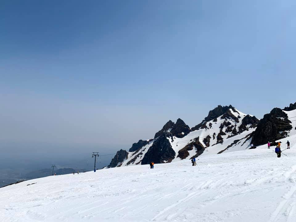
Whilst the parts of Europe seeing the most snow in the different snowstorms through November has tended to switch between the western and eastern side of the continent, Italian areas, in the middle, have tended to benefit from both systems and last weekend claimed the biggest accumulations of all with up to 1.5m (5ft) of new snow in the Piedmont region. Cervinia (200/320cm) got another 70cm of snow on top of the 2.4 metres it reported a week ago meaning more than 3 metres (10 feet) of snowfall during November and that’s reflected in one of the world’s deepest reported snow depths at present. However, the Presena glacier, with 80cm of fresh snow, is reporting its base depth has reached 4 metres, the deepest in the world at present.
ANDORRA
The season is really starting to take off in the Pyrenees with most of the major resorts in the area opening last weekend, particularly in Andorra and on the Spanish side of the mountains where a big public holiday long weekend, in early December, is a major inducement to be open as early as possible. Formigal (20/180cm) is one of half a dozen leading Spanish areas now open with more than 40 runs skiable. Baqueira/Beret (60/90cm) has also opened reporting 38km of piste open, from day one, served by 10 lifts and 5-10cm of fresh snow. Ski centres in Andorra have also opened reporting similar conditions. Fewer have done so as yet on the French-side although Cauterets (140/180cm), which reported another 20cm of snow on Monday morning, opened its smaller sector early at the weekend immediately posting the deepest base in the Pyrenees, and indeed in France. It will fully open this coming weekend. Down to the south of the region Sierra Nevada (60/80cm), in Spain (Europe’s most southerly major area), is also open with about 30 runs skiable so far.
NORWAY/SWEDEN

Things are continuing to look lovely and snowy in Scandinavia with snowfall for many areas through the weekend and into this week. About 40 areas are now open across the region with typically 30-60cm snow depths and 5-10 runs open. Bigger areas are now opening more terrain almost daily as the main season gets closer and dozens more areas are expected to open over the next few weekends.
GERMANY

So far only the Zugspitze Glacier ski area (40/60cm) is reported open in Germany with little fresh snowfall over the past week. It has around half of its slopes open. Most German ski areas open just a week or two before Christmas but several larger centres are expected to open over the next few weeks if snow conditions are good.
BULGARIA
There was palpable excitement in Bulgaria as ski resorts there reported a good snowfall at the weekend, turning the slopes white again. The largest, Bansko, is among the areas hoping to open at least some terrain from next weekend to get the season started there.
JAPAN
The season does not appear to be off to the best of starts in Japan. There’s been a little fresh snow at Niseko but opening day is currently on hold until more arrives; the autumn total is down on the past two years. It’s a similar picture ion Nozawa Onsen but Furana, which reports 66cm of snowfall so far this season although only a thin covering on the slopes, has managed to open three short runs.
SCOTLAND

Scotland is continuing to look good ahead of the 2019-20 season start but temperatures are rising a little bit so there’s some concern for the thin snowpack. However, all five Highland centres have now announced they’re going to be running all-weather snow-making systems this winter, with Nevis Range the latest to announce it has invested in a new machine from a Dutch company. Therefore, all are currently optimistic of a December opening. Glencoe is the latest to suggest opening day is imminent following The Lecht making a similar statement last week, without either committing to a day.
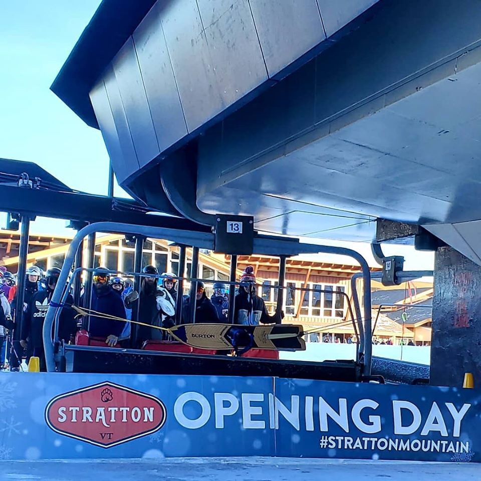
USA

In the US the big focus is on the Thanksgiving long weekend that is just upon us and it looks like at least 100 areas will be open across the country (more than the rest of the world combined) in time for the holidays. It appears snow conditions are picking up gradually too, with the first ‘powder alarms’ for 20+cm/8 inches+ in 24 hours since October issued on both east and west coasts and more snow is in the forecast for the next few days (but not huge quantities). The biggest relief has been in California where it has been warm and dry and without the October snowfalls Colorado had to fall back on. Wildcat (25/51cm), Bretton Woods (41/61cm) and Sugarloaf (25/41cm) in the east, were among the areas reporting 25-30cm (10-12 inches) of fresh snow in the previous 24 hours on Monday morning.
CANADA

Half-a-dozen more ski areas opened in Canada at the weekend taking the tally there into double figures. Many of the big names are yet to open, including Whistler which should open later this week. Sun Peaks (45/67cm) is the first area in BC to open, reporting a couple of runs as being available. Otherwise, in terms of bigger resorts, it is still an Alberta focus with the three Banff ski areas and Marmot Basin (60/60cm), near Jasper to the north, all reporting good early season conditions and more than 20cm of fresh snowfall in the past week. Lake Louise (76/86cm) will host the opening World cup Downhill speed events of the 19-20 season this weekend and already has more than 80 runs skiable.
EUROPEAN WEATHER OUTLOOK

It appears that November will continue to be snowy in the Alps right to the end, making it surely one of the snowiest Novembers in recent years here. After the past few clear days, the next wave of snowfall is due to move in mid-week with up to 70cm more forecast by the weekend with the French Alps, at this time, looking set to be the snowiest according to the forecasting models with Tignes topping the predictions with another 70cm there. The heaviest snowfall currently looks like it will be in the western Alps but then there should be at least light snow further east with 20-50cm more snow likely in Austria and eastern Switzerland as well as down in the Dolomites. In the Pyrenees, it’s looking like a fairly dry week ahead but with some snowfall likely at the weekend, potentially quite considerable falls if forecasts play out as hoped. For Scotland, it has warmed up but another temperature dip is expected at the weekend so hopefully, forecast precipitation will fall more as snow than rain.
NORTH AMERICAN WEATHER OUTLOOK

The forecast is definitely looking more promising for much of North America than it has for most of November. Following on from recent falls, California and more southerly ski states like Colorado and Arizona are in line for 30-60cm of snowfall with the next round of 20-40cm heavier snow expected in the east later in the week. Unfortunately, north of the border in Canada it’s a less snowy outlook across the country at present. Perhaps 10-20cm is possible in total over the rest of the week.