

A New Largest Ski Area in New Zealand?
The Remarkables is hoping to overtake Cardrona as New Zealand’s largest ski area under a major NZD 150 million‑plus expansion proposal lodged by owner NZSki.

Next 3 days weather summary:Light rain (total 8.0mm), mostly falling on Fri night. Warm (max 31°C on Fri afternoon, min 17°C on Wed night). Wind will be generally light. | Days 4-6 weather summary:Heavy rain (total 76.0mm), heaviest during Mon night. Warm (max 32°C on Sat afternoon, min 17°C on Mon night). Wind will be generally light. | |||||||||||||||||
Wednesday 24 | Thursday 25 | Friday 26 | Saturday 27 | Sunday 28 | Monday 29 | |||||||||||||
AM | PM | night | AM | PM | night | AM | PM | night | AM | PM | night | AM | PM | night | AM | PM | night | |
t-storm risk | light rain | rain shwrs | clear | clear | clear | clear | t-storm risk | t-storm risk | clear | t-storm risk | rain shwrs | clear | some clouds | rain shwrs | t-storm risk | heavy rain | heavy rain | |
km/h | ||||||||||||||||||
Snow map |  |  |  |  |  |  | ||||||||||||
— | — | — | — | — | — | — | — | — | — | — | — | — | — | — | — | — | — | |
mm | 1 | 1 | 2 | — | — | — | — | 1 | 3 | — | 2 | 14 | — | — | 7 | 1 | 22 | 30 |
max °C | 26 | 29 | 22 | 27 | 29 | 24 | 28 | 31 | 24 | 30 | 32 | 20 | 29 | 31 | 23 | 28 | 25 | 17 |
min °C | 21 | 27 | 17 | 22 | 29 | 18 | 24 | 30 | 19 | 24 | 25 | 18 | 24 | 29 | 18 | 23 | 19 | 17 |
chill °C | 21 | 27 | 17 | 22 | 29 | 18 | 24 | 30 | 19 | 24 | 25 | 18 | 24 | 29 | 18 | 23 | 19 | 17 |
Humid % | 53 | 49 | 78 | 47 | 36 | 78 | 50 | 43 | 77 | 47 | 69 | 68 | 42 | 49 | 75 | 49 | 94 | 89 |
Freeze m | 4150 | 4300 | 4250 | 4400 | 4500 | 4450 | 4400 | 4600 | 4550 | 4500 | 4700 | 4650 | 4550 | 4650 | 4650 | 4500 | 4300 | 4050 |
5:11 | — | — | 5:13 | — | — | 5:13 | — | — | 5:13 | — | — | 5:13 | — | — | 5:13 | — | — | |
— | — | 9:08 | — | — | 9:08 | — | — | 9:08 | — | — | 9:08 | — | — | 9:08 | — | — | 9:08 | |
Go pro and carve into:
Avalanche information: European Avalanche Warning Services (EAWS)
Latest snow reports near Zell am See:
| Top snow depth: | 0 cm |
|---|---|
| Bottom snow depth: | 0 cm |
| Fresh snowfall depth: | — |
| Last snowfall: | 16 May 2026 |
| Snow Alerts | Create Alert |
0.0 | Bluebird Powder days Fresh snow, mostly sunny, light wind. |
|---|---|
0.0 | Powder days Fresh snow, limited sun, any wind. |
0.0 | Bluebird days Average snow, mostly sunny, light wind. |
The above table gives the weather forecast for Zell am See at the specific elevation of 758 m. Our sophisticated weather models allow us to provide snow forecasts for the top, middle and bottom ski stations of Zell am See. To access the weather forecasts for the other elevations, use the tab navigation above the table. For a wider view of the weather, check out the Weather Map of Austria.
Click here to read further information on freezing levels and how we forecast our temperatures.
Overall 4.1 Based on 27 votes and 25 reviews
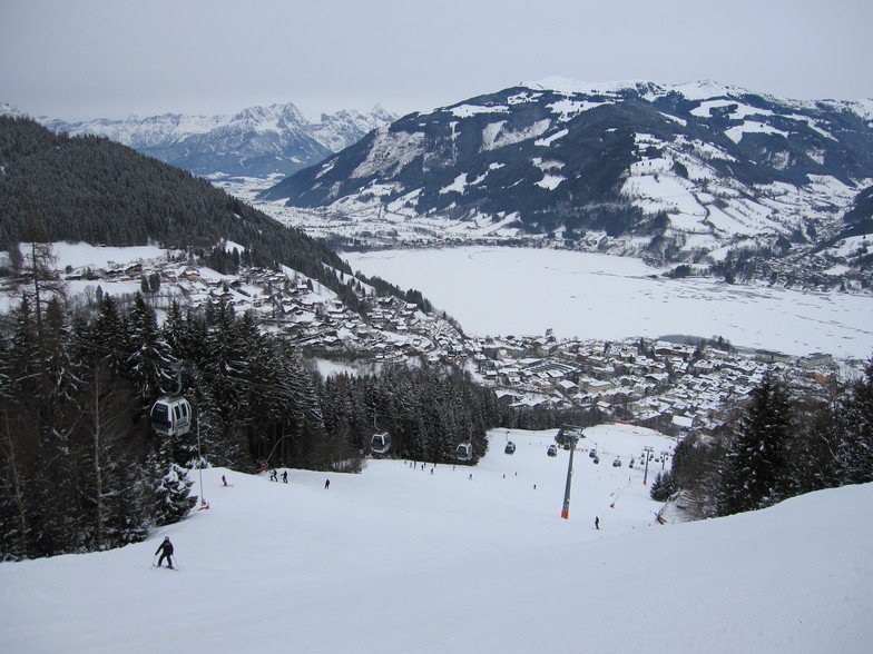
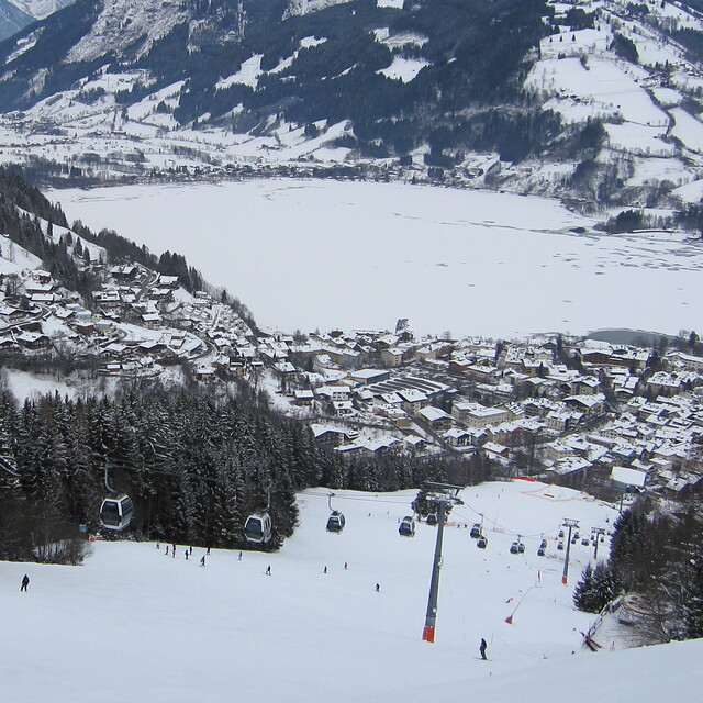
Zell is a massive compromise. The town itself is lovely. Some genuinely interesting architecture and history, a great ice rink and ice hockey team, the swimming pool in the town is amazing with slides and boards as well as the best burgers and pizzas anywhere! The town has a 90 minute train ride from Salzburg for less than €15 at the best times. However, the skiing is pretty poor on the Schmittenhoe. It's a days worth for an average intermediate, is badly laid out, has a couple of pointless cable cars and it takes 3 lifts to get to the summit from most entry points, bizarre. For a ‘bowl’ type hill it’s a mess due to a legacy of strange lift choices and designs. Most of the runs are pretty short and limited. The SchnappsHans development on the summit is a gruesome eyesore now, which dwarfs the iconic Sisi Chapel, and drags the hill into the French domain of ugly buildings in incongruous places, a real shame. The new 2019 link to Saalbach opens up your eyes to a far better skiing domain. The ZellExpress is a fine new gondola, quick and efficient. Again it doesn’t quite take you to the summit but leaves you needing more lifts to access the mountain. The new red slope off the back of the Schmittenhoe down to the Saalbach valley is steep in places and icy most of the time as it gets no sun. Once in Saalbach the valley provides a more extensive and simpler place to ski with endless linked blue and red runs providing opportunity for all. Alternatively, take the 680 bus from Zell for €5 and you’re there in 30 mins. Kaprun and the Kitzsteinhorn provide great views and glacier skiing, but again it's a fair haul for limited skiing although some free-ride expanse can be found. In all, its a great town with much to like; however, it's as complex and hard work to get around as Chamonix with far less ski domain and even more walking!
Richard from United Kingdom writes:
Zell is a massive compromise.
The town itself is lovely. Some genuinely interesting architecture and history, a great ice rink and ice hockey team, the swimming pool in the town is amazing with slides and boards as well as the best burgers and pizzas anywhere! The town has a 90 minute train ride from Salzburg for less than €15 at the best times.
However, the skiing is pretty poor on the Schmittenhoe. It's a days worth for an average intermediate, is badly laid out, has a couple of pointless cable cars and it takes 3 lifts to get to the summit from most entry points, bizarre. For a ‘bowl’ type hill it’s a mess due to a legacy of strange lift choices and designs. Most of the runs are pretty short and limited.
The SchnappsHans development on the summit is a gruesome eyesore now, which dwarfs the iconic Sisi Chapel, and drags the hill into the French domain of ugly buildings in incongruous places, a real shame.
The new 2019 link to Saalbach opens up your eyes to a far better skiing domain. The ZellExpress is a fine new gondola, quick and efficient. Again it doesn’t quite take you to the summit but leaves you needing more lifts to access the mountain. The new red slope off the back of the Schmittenhoe down to the Saalbach valley is steep in places and icy most of the time as it gets no sun. Once in Saalbach the valley provides a more extensive and simpler place to ski with endless linked blue and red runs providing opportunity for all. Alternatively, take the 680 bus from Zell for €5 and you’re there in 30 mins.
Kaprun and the Kitzsteinhorn provide great views and glacier skiing, but again it's a fair haul for limited skiing although some free-ride expanse can be found.
In all, its a great town with much to like; however, it's as complex and hard work to get around as Chamonix with far less ski domain and even more walking!


 Nearest