


Global Weekly Snow Roundup #320
Weekly Snow News for the world, updated 25 June 2026: Chile and New Zealand's seasons proper set to begin, Tignes and Sunshine reopen for summer skiing. weekend as Riksgransen ends its 2026 season.

Next 3 days weather summary:Some drizzle, heaviest during Sun night. Warm (max 28°C on Sat afternoon, min 14°C on Fri night). Wind will be generally light. | Days 4-6 weather summary:Light rain (total 9.0mm), mostly falling on Wed afternoon. Warm (max 27°C on Mon afternoon, min 12°C on Tue night). Wind will be generally light. | ||||||||||||||||
Fri 26 | Saturday 27 | Sunday 28 | Monday 29 | Tuesday 30 | Wednesday 1 | ||||||||||||
PM | night | AM | PM | night | AM | PM | night | AM | PM | night | AM | PM | night | AM | PM | night | |
some clouds | some clouds | some clouds | clear | some clouds | cloudy | some clouds | rain shwrs | some clouds | some clouds | clear | clear | cloudy | cloudy | light rain | rain shwrs | rain shwrs | |
km/h | |||||||||||||||||
Snow map | 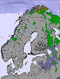 | 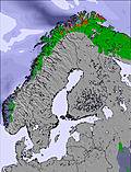 | 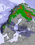 | 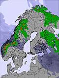 | 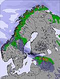 | 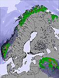 | |||||||||||
— | — | — | — | — | — | — | — | — | — | — | — | — | — | — | — | — | |
mm | — | — | — | — | — | — | — | 1 | — | — | — | — | — | — | 2 | 4 | 2 |
max °C | 26 | 21 | 25 | 28 | 23 | 26 | 28 | 23 | 25 | 27 | 23 | 21 | 23 | 19 | 18 | 21 | 17 |
min °C | 26 | 14 | 21 | 28 | 15 | 22 | 27 | 15 | 19 | 26 | 13 | 17 | 23 | 12 | 15 | 18 | 12 |
chill °C | 26 | 14 | 21 | 28 | 15 | 22 | 27 | 15 | 19 | 26 | 13 | 17 | 23 | 12 | 15 | 18 | 12 |
Humid % | 43 | 80 | 55 | 54 | 92 | 37 | 42 | 90 | 51 | 24 | 72 | 43 | 34 | 83 | 60 | 46 | 70 |
Freeze m | 3900 | 3900 | 4000 | 3950 | 3900 | 3500 | 3600 | 3450 | 3350 | 3200 | 2800 | 2750 | 2650 | 2600 | 2350 | 2500 | 2300 |
— | — | 3:55 | — | — | 3:56 | — | — | 3:57 | — | — | 3:57 | — | — | 3:58 | — | — | |
— | 10:44 | — | — | 10:44 | — | — | 10:44 | — | — | 10:43 | — | — | 10:43 | — | — | 10:42 | |
Go pro and carve into:
Avalanche information: Varsom.no Avalanche Warnings
Latest snow reports near Tryvann:
| Top snow depth: | 0 cm |
|---|---|
| Bottom snow depth: | 0 cm |
| Fresh snowfall depth: | — |
| Last snowfall: | 5 Apr 2026 |
| Snow Alerts | Create Alert |
0.0 | Bluebird Powder days Fresh snow, mostly sunny, light wind. |
|---|---|
0.0 | Powder days Fresh snow, limited sun, any wind. |
0.0 | Bluebird days Average snow, mostly sunny, light wind. |
The above table gives the weather forecast for Tryvann at the specific elevation of 144 m. Our sophisticated weather models allow us to provide snow forecasts for the top, middle and bottom ski stations of Tryvann. To access the weather forecasts for the other elevations, use the tab navigation above the table. For a wider view of the weather, check out the Weather Map of Norway.
Click here to read further information on freezing levels and how we forecast our temperatures.
Overall 1.8 Based on 13 votes and 1 review
Tryvann is the main resort in the city of Oslo. It is a small resort with 10km of slopes. It is very easily accessible, since the subway goes from the city center up to the resort in just half an hour. If you're going there for the runs, you will quickly be fed up, since it's small. On the other hand, the resort has a good snowpark, for all levels and with 2 half pipes. You can spend hours in the park without ever getting fed up. Conclusion: It's a good city resort, ideal for alpine ski/snowboard beginners and also for freestyle lovers.
Hugo Leitao from Portugal writes:
Tryvann is the main resort in the city of Oslo. It is a small resort with 10km of slopes. It is very easily accessible, since the subway goes from the city center up to the resort in just half an hour.
If you're going there for the runs, you will quickly be fed up, since it's small.
On the other hand, the resort has a good snowpark, for all levels and with 2 half pipes. You can spend hours in the park without ever getting fed up.
Conclusion: It's a good city resort, ideal for alpine ski/snowboard beginners and also for freestyle lovers.


 Nearest