


Europe Weekly Snow Roundup #321
Weekly Snow News for Europe, updated 2 July 2026: Fresh snowfall has been reported on high terrain in the Alps after the very warm end to June. Les 2 Alps ends its 7 months plus season this week.

Next 4 days weather summary:Heavy rain (total 27.0mm), heaviest during Sun afternoon. Warm (max 22°C on Sun morning, min 14°C on Fri night). Wind will be generally light. | Days 5-7 weather summary:Heavy rain (total 36.0mm), heaviest during Sun night. Warm (max 26°C on Wed morning, min 17°C on Sun night). Wind will be generally light. | |||||||||||||||
Friday 3 | Saturday 4 | Sunday 5 | Monday 6 | Tuesday 7 | ||||||||||||
night | AM | PM | night | AM | PM | night | AM | PM | night | AM | PM | night | AM | PM | night | |
mod. rain | rain shwrs | rain shwrs | some clouds | light rain | rain shwrs | rain shwrs | light rain | mod. rain | heavy rain | light rain | light rain | some clouds | light rain | mod. rain | rain shwrs | |
km/h | ||||||||||||||||
Snow map |  |  |  |  | 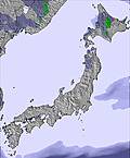 | 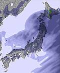 | ||||||||||
— | — | — | — | — | — | — | — | — | — | — | — | — | — | — | — | |
mm | 7 | 3 | 3 | — | 1 | 5 | 1 | 1 | 6 | 16 | 2 | 3 | — | 2 | 6 | 1 |
max °C | 18 | 20 | 21 | 16 | 21 | 20 | 17 | 22 | 20 | 18 | 19 | 20 | 18 | 23 | 22 | 20 |
min °C | 16 | 19 | 19 | 14 | 20 | 19 | 15 | 19 | 19 | 17 | 19 | 19 | 17 | 22 | 20 | 19 |
chill °C | 16 | 19 | 19 | 14 | 20 | 19 | 15 | 19 | 19 | 17 | 19 | 19 | 17 | 22 | 20 | 19 |
Humid % | 96 | 83 | 78 | 89 | 71 | 79 | 95 | 87 | 87 | 98 | 96 | 95 | 95 | 84 | 87 | 97 |
Freeze m | 4250 | 3950 | 4150 | 4300 | 4150 | 4150 | 4500 | 4300 | 4550 | 4400 | 4600 | 4500 | 4650 | 4750 | 5000 | 4950 |
— | 4:33 | — | — | 4:33 | — | — | 4:35 | — | — | 4:35 | — | — | 4:35 | — | — | |
— | — | 7:09 | — | — | 7:09 | — | — | 7:09 | — | — | 7:09 | — | — | 7:09 | — | |
Go pro and carve into:
Avalanche information: Japan Avalanche Network
Latest snow reports near Sun Alpina Keikyu Aokiko:
| Top snow depth: | — |
|---|---|
| Bottom snow depth: | — |
| Fresh snowfall depth: | — |
| Last snowfall: | 7 Apr 2026 |
| Snow Alerts | Create Alert |
0.0 | Bluebird Powder days Fresh snow, mostly sunny, light wind. |
|---|---|
0.0 | Powder days Fresh snow, limited sun, any wind. |
0.0 | Bluebird days Average snow, mostly sunny, light wind. |
The above table gives the weather forecast for Sun Alpina Keikyu Aokiko at the specific elevation of 850 m. Our sophisticated weather models allow us to provide snow forecasts for the top, middle and bottom ski stations of Sun Alpina Keikyu Aokiko. To access the weather forecasts for the other elevations, use the tab navigation above the table. For a wider view of the weather, check out the Weather Map of Japan.
Click here to read further information on freezing levels and how we forecast our temperatures.
Out of business.
Hiro from Japan writes:
Out of business.
Click here to submit your own review of Sun Alpina Keikyu Aokiko


 Nearest