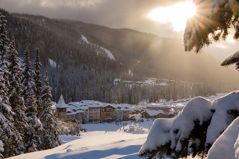


Global Weekly Snow Roundup #320
Weekly Snow News for the world, updated 25 June 2026: Chile and New Zealand's seasons proper set to begin, Tignes and Sunshine reopen for summer skiing. weekend as Riksgransen ends its 2026 season.

Next 3 days weather summary:Light rain (total 9.0mm), mostly falling on Fri afternoon. Very mild (max 16°C on Sun afternoon, min 7°C on Fri night). Wind will be generally light. | Days 4-6 weather summary:Heavy rain (total 22.0mm), heaviest during Tue morning. Warm (max 21°C on Mon afternoon, min 6°C on Wed night). Wind will be generally light. | |||||||||||||||||
Friday 26 | Saturday 27 | Sunday 28 | Monday 29 | Tuesday 30 | Wednesday 1 | |||||||||||||
AM | PM | night | AM | PM | night | AM | PM | night | AM | PM | night | AM | PM | night | AM | PM | night | |
cloudy | light rain | light rain | light rain | light rain | cloudy | rain shwrs | cloudy | light rain | some clouds | some clouds | light rain | light rain | light rain | rain shwrs | rain shwrs | rain shwrs | light rain | |
km/h | ||||||||||||||||||
Snow map | 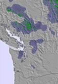 | 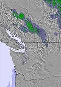 | 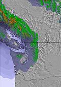 | 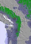 |  |  | ||||||||||||
— | — | — | — | — | — | — | — | — | — | — | — | — | — | — | — | — | — | |
mm | — | 1 | 2 | 2 | 1 | — | 1 | — | 2 | — | — | 4 | 4 | 4 | 4 | 2 | 1 | 3 |
max °C | 12 | 13 | 11 | 8 | 9 | 10 | 15 | 16 | 13 | 16 | 21 | 17 | 10 | 11 | 11 | 14 | 17 | 14 |
min °C | 12 | 13 | 7 | 7 | 9 | 8 | 11 | 16 | 9 | 11 | 20 | 10 | 9 | 10 | 8 | 9 | 17 | 6 |
chill °C | 11 | 12 | 6 | 6 | 8 | 8 | 11 | 15 | 8 | 11 | 20 | 10 | 8 | 10 | 8 | 9 | 16 | 5 |
Humid % | 65 | 68 | 81 | 93 | 89 | 82 | 61 | 58 | 88 | 71 | 44 | 87 | 96 | 94 | 90 | 68 | 43 | 81 |
Freeze m | 2750 | 2800 | 2700 | 2600 | 2750 | 2800 | 2900 | 3100 | 3650 | 3700 | 3550 | 3400 | 3050 | 3050 | 2900 | 2800 | 2950 | 2700 |
4:46 | — | — | 4:47 | — | — | 4:47 | — | — | 4:48 | — | — | 4:48 | — | — | 4:48 | — | — | |
— | — | 9:16 | — | — | 9:16 | — | — | 9:16 | — | — | 9:16 | — | — | 9:16 | — | — | 9:15 | |
Go pro and carve into:
Avalanche information: Avalanche Canada
Latest snow reports near Sun Peaks:
| Top snow depth: | 0 cm |
|---|---|
| Bottom snow depth: | 0 cm |
| Fresh snowfall depth: | — |
| Last snowfall: | 10 Jun 2026 |
| Snow Alerts | Create Alert |
0.0 | Bluebird Powder days Fresh snow, mostly sunny, light wind. |
|---|---|
0.0 | Powder days Fresh snow, limited sun, any wind. |
0.0 | Bluebird days Average snow, mostly sunny, light wind. |
The above table gives the weather forecast for Sun Peaks at the specific elevation of 1186 m. Our sophisticated weather models allow us to provide snow forecasts for the top, middle and bottom ski stations of Sun Peaks. To access the weather forecasts for the other elevations, use the tab navigation above the table. For a wider view of the weather, check out the Weather Map of Canada.
Click here to read further information on freezing levels and how we forecast our temperatures.
Overall 4.4 Based on 42 votes and 15 reviews
Our children learnt to ski here aged 3 and 5 and are now 14 and 16. We have come here most years so I feel confident that I know the resort well enough to leave a review! Sun Peaks has been our little secret gem as it's little known in the UK. The long travel time to get there from Europe is most definitely worth it. Travel is via Calgary or Vancouver and then a small plane flight to Kamloops and a shuttle bus (about 13 hours in total from London). So what makes it worth it? 1. The weather conditions: with temperature rarely getting above freezing by day you don't get the morning ice/afternoon slush of many resorts. It's colder and drier than the coast so sleet is not a problem. Even if it hasn't snowed for a few days there is always a good covering. This year 2018 exceptionally so. Last year was the only year we experienced anything like European snow conditions and even then nothing in comparison. 2. Hardly any line-ups and certainly no European pushing and shoving in the queue. In fact, everyone is so polite and merging lines work really well. 3. Huge runs, especially width and in some cases length (Green 5 Mile run) on most days except perhaps President Week, you can be skiing totally on your own! The runs range from beginners to experienced skiers. We now all ski most runs except the double diamonds and there's plenty to keep us happy for a week. 4. Lovely village with great choice of restaurants. Latest addition a Poutine shop - chips, gravy, cheese curds! Yum. 5. Friendly locals. We have stayed in pretty much all the different types of accommodation available. We started in a house in the forest area year one but quickly realised it was worth paying more to ski-in, ski-out. Since then we have stayed at the Cahilty and Sundance Lodge and family, with bigger budgets than ours, have stayed at the Delta/Grand. All clean and what you need with ski lockers provided. If you are adults only and have a good budget the 5th floor (9 adults preferred) at the Grand comes highly recommended. We love Sun Peaks. Please don't all come as we love the fact it isn't a second Whistler! For kids learning to ski the ski nursery/lesson facilities are amazing. Being European I thought 3 years old was too young for my child to learn, but no. In Canada, children are on skis from when they can walk, literally! My son, at three, had a one lesson factored in to his care at the Nursery and he coped. He is now a great skier. If you're in your teens/20's you will find Sun Peaks too quiet as there is not much night life, except for restaurants and a pub. However, for families and older adults it's perfect. Please Sun Peaks don't change.
Helen Rees from United Kingdom writes:
Our children learnt to ski here aged 3 and 5 and are now 14 and 16. We have come here most years so I feel confident that I know the resort well enough to leave a review! Sun Peaks has been our little secret gem as it's little known in the UK. The long travel time to get there from Europe is most definitely worth it. Travel is via Calgary or Vancouver and then a small plane flight to Kamloops and a shuttle bus (about 13 hours in total from London). So what makes it worth it?
1. The weather conditions: with temperature rarely getting above freezing by day you don't get the morning ice/afternoon slush of many resorts. It's colder and drier than the coast so sleet is not a problem. Even if it hasn't snowed for a few days there is always a good covering. This year 2018 exceptionally so. Last year was the only year we experienced anything like European snow conditions and even then nothing in comparison.
2. Hardly any line-ups and certainly no European pushing and shoving in the queue. In fact, everyone is so polite and merging lines work really well.
3. Huge runs, especially width and in some cases length (Green 5 Mile run) on most days except perhaps President Week, you can be skiing totally on your own! The runs range from beginners to experienced skiers. We now all ski most runs except the double diamonds and there's plenty to keep us happy for a week.
4. Lovely village with great choice of restaurants. Latest addition a Poutine shop - chips, gravy, cheese curds! Yum.
5. Friendly locals.
We have stayed in pretty much all the different types of accommodation available. We started in a house in the forest area year one but quickly realised it was worth paying more to ski-in, ski-out. Since then we have stayed at the Cahilty and Sundance Lodge and family, with bigger budgets than ours, have stayed at the Delta/Grand.
All clean and what you need with ski lockers provided. If you are adults only and have a good budget the 5th floor (9 adults preferred) at the Grand comes highly recommended.
We love Sun Peaks. Please don't all come as we love the fact it isn't a second Whistler!
For kids learning to ski the ski nursery/lesson facilities are amazing. Being European I thought 3 years old was too young for my child to learn, but no. In Canada, children are on skis from when they can walk, literally! My son, at three, had a one lesson factored in to his care at the Nursery and he coped. He is now a great skier.
If you're in your teens/20's you will find Sun Peaks too quiet as there is not much night life, except for restaurants and a pub. However, for families and older adults it's perfect.
Please Sun Peaks don't change.


 Nearest