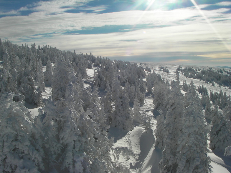


America’s Next Indoor Snow Centre Takes Shape
Construction of a new indoor snow centre for skiers, boarders and tubers appears to be making good progress at Heritage Farm in Wayne County, West Virginia.

Next 3 days weather summary:Light rain (total 5.0mm), mostly falling on Thu morning. Very mild (max 10°C on Wed afternoon, min 4°C on Thu night). Winds decreasing (strong winds from the NW on Thu afternoon, light winds from the NW by Fri night). | Days 4-6 weather summary:Moderate rain (total 16.0mm), heaviest on Sun afternoon. Very mild (max 17°C on Sat night, min 10°C on Sat morning). Winds increasing (calm on Sun morning, fresh winds from the NW by Mon night). | |||||||||||||||||
Wednesday 22 | Thursday 23 | Friday 24 | Saturday 25 | Sunday 26 | Monday 27 | |||||||||||||
AM | PM | night | AM | PM | night | AM | PM | night | AM | PM | night | AM | PM | night | AM | PM | night | |
rain shwrs | cloudy | some clouds | rain shwrs | rain shwrs | clear | some clouds | clear | clear | some clouds | some clouds | some clouds | some clouds | mod. rain | rain shwrs | some clouds | rain shwrs | rain shwrs | |
km/h | ||||||||||||||||||
Snow map |  |  |  |  |  |  | ||||||||||||
— | — | — | — | — | — | — | — | — | — | — | — | — | — | — | — | — | — | |
mm | 1 | — | — | 3 | 1 | — | — | — | — | — | — | — | — | 8 | 6 | — | 1 | 1 |
max °C | 7 | 10 | 10 | 8 | 8 | 7 | 7 | 10 | 10 | 11 | 14 | 17 | 16 | 15 | 12 | 11 | 12 | 11 |
min °C | 5 | 8 | 9 | 7 | 8 | 4 | 4 | 8 | 9 | 10 | 14 | 14 | 16 | 13 | 11 | 11 | 12 | 10 |
chill °C | 0 | 4 | 6 | 3 | 4 | -2 | -1 | 4 | 7 | 9 | 13 | 13 | 16 | 12 | 9 | 8 | 9 | 6 |
Humid % | 64 | 52 | 60 | 79 | 57 | 70 | 50 | 47 | 47 | 45 | 48 | 45 | 57 | 77 | 70 | 80 | 70 | 53 |
Freeze m | 2550 | 2850 | 2950 | 2800 | 2850 | 2600 | 2850 | 3000 | 3300 | 3700 | 3750 | 4250 | 4000 | 3750 | 3550 | 3400 | 3650 | 3900 |
5:20 | — | — | 5:22 | — | — | 5:22 | — | — | 5:24 | — | — | 5:26 | — | — | 5:26 | — | — | |
— | — | 8:44 | — | — | 8:43 | — | — | 8:42 | — | — | 8:40 | — | — | 8:38 | — | — | 8:37 | |
Go pro and carve into:
Avalanche information: European Avalanche Warning Services (EAWS)
Latest snow reports near Stuhleck:
| Top snow depth: | 0 cm |
|---|---|
| Bottom snow depth: | 0 cm |
| Fresh snowfall depth: | — |
| Last snowfall: | 12 May 2026 |
| Snow Alerts | Create Alert |
0.0 | Bluebird Powder days Fresh snow, mostly sunny, light wind. |
|---|---|
0.0 | Powder days Fresh snow, limited sun, any wind. |
0.0 | Bluebird days Average snow, mostly sunny, light wind. |
The above table gives the weather forecast for Stuhleck at the specific elevation of 1774 m. Our sophisticated weather models allow us to provide snow forecasts for the top, middle and bottom ski stations of Stuhleck. To access the weather forecasts for the other elevations, use the tab navigation above the table. For a wider view of the weather, check out the Weather Map of Austria.
Click here to read further information on freezing levels and how we forecast our temperatures.
Overall 3.1 Based on 19 votes and 3 reviews
I will never go back here. Despite great trails on a great little mountain, albeit poorly groomed, the crowds, the lack of ski etiquette on the slopes, and the complete unfriendliness will guarantee no repeat visit. Crowds, on the weekend, were ridiculous and the pushiness in long lift lines had inexcusable human behavior that was beyond atrocious. Don't even think of renting ski gear, we were in line for one full hour. The rental staff were very professional though considering how slammed they were. The food was Austrian. What can I say, "I can't eat this", but I am in Austria and what can one expect besides pork?
Bunny from Austria writes:
I will never go back here. Despite great trails on a great little mountain, albeit poorly groomed, the crowds, the lack of ski etiquette on the slopes, and the complete unfriendliness will guarantee no repeat visit. Crowds, on the weekend, were ridiculous and the pushiness in long lift lines had inexcusable human behavior that was beyond atrocious. Don't even think of renting ski gear, we were in line for one full hour. The rental staff were very professional though considering how slammed they were. The food was Austrian. What can I say, "I can't eat this", but I am in Austria and what can one expect besides pork?


 Nearest