

Global Weekly Snow Roundup #320
Weekly Snow News for the world, updated 25 June 2026: Chile and New Zealand's seasons proper set to begin, Tignes and Sunshine reopen for summer skiing. weekend as Riksgransen ends its 2026 season.

Next 3 days weather summary:Moderate rain (total 11.0mm), heaviest on Sat night. Warm (max 33°C on Sat afternoon, min 17°C on Sat night). Wind will be generally light. | Days 4-6 weather summary:Heavy rain (total 77.0mm), heaviest during Mon night. Warm (max 30°C on Mon afternoon, min 11°C on Wed night). Wind will be generally light. | |||||||||||||||||
Friday 26 | Saturday 27 | Sunday 28 | Monday 29 | Tuesday 30 | Wednesday 1 | |||||||||||||
AM | PM | night | AM | PM | night | AM | PM | night | AM | PM | night | AM | PM | night | AM | PM | night | |
clear | clear | clear | clear | t-storm risk | rain shwrs | clear | some clouds | mod. rain | some clouds | t-storm risk | rain shwrs | clear | t-storm risk | heavy rain | heavy rain | light rain | rain shwrs | |
km/h | ||||||||||||||||||
Snow map |  |  |  |  |  |  | ||||||||||||
— | — | — | — | — | — | — | — | — | — | — | — | — | — | — | — | — | — | |
mm | — | — | — | — | 1 | 4 | — | — | 6 | — | 1 | 22 | — | 7 | 28 | 14 | 3 | 2 |
max °C | 29 | 31 | 26 | 30 | 33 | 20 | 31 | 33 | 24 | 28 | 30 | 18 | 27 | 29 | 19 | 14 | 17 | 15 |
min °C | 23 | 31 | 19 | 24 | 31 | 17 | 23 | 33 | 17 | 21 | 29 | 15 | 20 | 22 | 16 | 14 | 16 | 11 |
chill °C | 23 | 31 | 19 | 24 | 31 | 17 | 23 | 33 | 17 | 21 | 29 | 15 | 20 | 22 | 16 | 14 | 16 | 11 |
Humid % | 45 | 38 | 66 | 48 | 45 | 67 | 44 | 33 | 78 | 55 | 53 | 83 | 55 | 86 | 96 | 87 | 76 | 91 |
Freeze m | 4450 | 4550 | 4600 | 4550 | 4600 | 4650 | 4600 | 4650 | 4550 | 4450 | 4450 | 4400 | 4300 | 4350 | 3550 | 3000 | 3300 | 3600 |
5:15 | — | — | 5:15 | — | — | 5:16 | — | — | 5:16 | — | — | 5:16 | — | — | 5:16 | — | — | |
— | — | 9:12 | — | — | 9:12 | — | — | 9:12 | — | — | 9:12 | — | — | 9:12 | — | — | 9:12 | |
Go pro and carve into:
Avalanche information: European Avalanche Warning Services (EAWS)
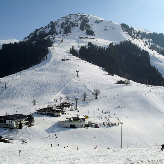
Latest snow reports near Söll (SkiWelt):
| Top snow depth: | 0 cm |
|---|---|
| Bottom snow depth: | 0 cm |
| Fresh snowfall depth: | — |
| Last snowfall: | 16 May 2026 |
| Snow Alerts | Create Alert |
0.0 | Bluebird Powder days Fresh snow, mostly sunny, light wind. |
|---|---|
0.0 | Powder days Fresh snow, limited sun, any wind. |
0.0 | Bluebird days Average snow, mostly sunny, light wind. |
The above table gives the weather forecast for Söll (SkiWelt) at the specific elevation of 620 m. Our sophisticated weather models allow us to provide snow forecasts for the top, middle and bottom ski stations of Söll (SkiWelt). To access the weather forecasts for the other elevations, use the tab navigation above the table. For a wider view of the weather, check out the Weather Map of Austria.
Click here to read further information on freezing levels and how we forecast our temperatures.
Resort name is also written as Soll.
Overall 4.2 Based on 36 votes and 52 reviews
Been visiting Soll for many years and still love the varied pistes, stunning views and excellent food and drink. Totally recommend the Hotel Postwirt. Constant lift and snow-making investments recently have made this a very worthwhile resort to visit. Depending on conditions there are some reasonable blacks, good reds and an intermediates cruising paradise.
Richard Brewer from United Kingdom writes:
Been visiting Soll for many years and still love the varied pistes, stunning views and excellent food and drink.
Totally recommend the Hotel Postwirt.
Constant lift and snow-making investments recently have made this a very worthwhile resort to visit.
Depending on conditions there are some reasonable blacks, good reds and an intermediates cruising paradise.


 Nearest