

America’s Next Indoor Snow Centre Takes Shape
Construction of a new indoor snow centre for skiers, boarders and tubers appears to be making good progress at Heritage Farm in Wayne County, West Virginia.

Next 3 days weather summary:Moderate rain (total 11.0mm), heaviest on Tue afternoon. Very mild (max 17°C on Wed afternoon, min 8°C on Tue night). Wind will be generally light. | Days 4-6 weather summary:Moderate rain (total 16.0mm), heaviest on Sat night. Warm (max 23°C on Sat afternoon, min 7°C on Thu night). Wind will be generally light. | |||||||||||||||||
Monday 20 | Tuesday 21 | Wednesday 22 | Thursday 23 | Friday 24 | Saturday 25 | |||||||||||||
AM | PM | night | AM | PM | night | AM | PM | night | AM | PM | night | AM | PM | night | AM | PM | night | |
some clouds | t-storm risk | rain shwrs | t-storm risk | rain shwrs | rain shwrs | clear | some clouds | some clouds | rain shwrs | rain shwrs | rain shwrs | clear | clear | some clouds | clear | clear | mod. rain | |
km/h | ||||||||||||||||||
Snow map |  |  |  |  |  |  | ||||||||||||
— | — | — | — | — | — | — | — | — | — | — | — | — | — | — | — | — | — | |
mm | — | 2 | 1 | 1 | 4 | 3 | — | — | — | 1 | 5 | 2 | — | — | — | — | — | 8 |
max °C | 14 | 15 | 13 | 14 | 14 | 11 | 13 | 17 | 14 | 10 | 11 | 10 | 14 | 19 | 15 | 19 | 23 | 18 |
min °C | 10 | 15 | 10 | 10 | 13 | 8 | 9 | 16 | 9 | 9 | 11 | 7 | 9 | 17 | 11 | 14 | 22 | 11 |
chill °C | 10 | 15 | 10 | 10 | 12 | 8 | 9 | 16 | 9 | 9 | 10 | 7 | 9 | 17 | 11 | 14 | 22 | 11 |
Humid % | 64 | 63 | 81 | 66 | 63 | 78 | 56 | 37 | 62 | 79 | 68 | 77 | 44 | 29 | 60 | 33 | 29 | 89 |
Freeze m | 3350 | 3500 | 3450 | 3350 | 3200 | 2800 | 3100 | 3400 | 3100 | 2950 | 2950 | 2800 | 3650 | 3800 | 3900 | 3900 | 4150 | 3600 |
5:37 | — | — | 5:39 | — | — | 5:39 | — | — | 5:41 | — | — | 5:43 | — | — | 5:43 | — | — | |
— | — | 9:02 | — | — | 9:01 | — | — | 9:00 | — | — | 9:00 | — | — | 8:59 | — | — | 8:58 | |
Go pro and carve into:
Avalanche information: European Avalanche Warning Services (EAWS)
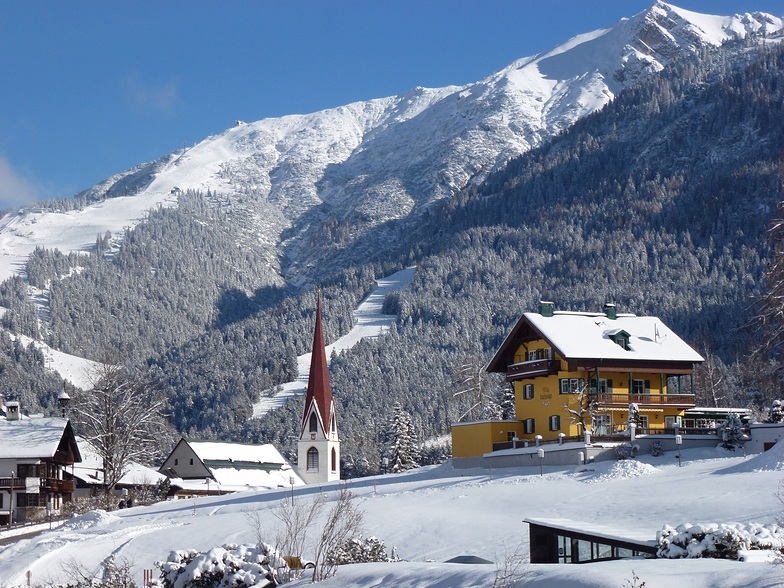
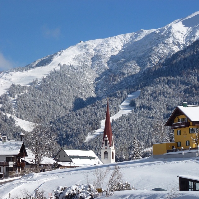
Latest snow reports near Seefeld-Reith/Gschwandtkopf:
| Top snow depth: | 0 cm |
|---|---|
| Bottom snow depth: | 0 cm |
| Fresh snowfall depth: | — |
| Last snowfall: | 16 May 2026 |
| Snow Alerts | Create Alert |
0.0 | Bluebird Powder days Fresh snow, mostly sunny, light wind. |
|---|---|
0.0 | Powder days Fresh snow, limited sun, any wind. |
0.0 | Bluebird days Average snow, mostly sunny, light wind. |
The above table gives the weather forecast for Seefeld-Reith/Gschwandtkopf at the specific elevation of 1500 m. Our sophisticated weather models allow us to provide snow forecasts for the top, middle and bottom ski stations of Seefeld-Reith/Gschwandtkopf. To access the weather forecasts for the other elevations, use the tab navigation above the table. For a wider view of the weather, check out the Weather Map of Austria.
Click here to read further information on freezing levels and how we forecast our temperatures.
Resort name is also written as Seefeld-Reith-Gschwandtkopf.
Overall 3.9 Based on 12 votes and 1 review
On the face of it Seefeld's second mountain has little to attract the diehard skier, but that would be to do the area a serious injustice! With a vertical of only 300m this puts the Geschwandtkopf on a par and scale with say Glenshee, but beyond that all the comparables end. Why? Because all the runs are north facing so are snow sure through the season, the pistes are all deserted, so very little if any ice and the mountain has two FIS rated race pistes which many national teams train and race on. Overall, the skiing is best suited to intermediates and beginners but advanced skiers will have a good day here too. Add to all of this the subline views of the Inn Valley and Seefeld plateau, the high quality and very reasonably priced Sportalm at the bottom, which is perfect for celebrity spotting (we saw Claudia Schiffer there one Sunday!) and the fact that Seefeld is one of the best all-round winter sports resort in the Alps and you have the perfect ingredients for a very enjoyable day or two as an alternative Seefeld's other ski area the Rosshutte. Recommended in small doses as part of a weeks stay in beautiful Seefeld.
Tirolerhund from United Kingdom writes:
On the face of it Seefeld's second mountain has little to attract the diehard skier, but that would be to do the area a serious injustice!
With a vertical of only 300m this puts the Geschwandtkopf on a par and scale with say Glenshee, but beyond that all the comparables end. Why? Because all the runs are north facing so are snow sure through the season, the pistes are all deserted, so very little if any ice and the mountain has two FIS rated race pistes which many national teams train and race on.
Overall, the skiing is best suited to intermediates and beginners but advanced skiers will have a good day here too.
Add to all of this the subline views of the Inn Valley and Seefeld plateau, the high quality and very reasonably priced Sportalm at the bottom, which is perfect for celebrity spotting (we saw Claudia Schiffer there one Sunday!) and the fact that Seefeld is one of the best all-round winter sports resort in the Alps and you have the perfect ingredients for a very enjoyable day or two as an alternative Seefeld's other ski area the Rosshutte.
Recommended in small doses as part of a weeks stay in beautiful Seefeld.
Click here to submit your own review of Seefeld-Reith/Gschwandtkopf


 Nearest