


Banff Sunshine Village Opening for Summer Skiing
Banff Sunshine Village has confirmed it will reopen for a fortnight of summer skiing, from this weekend. The only ski area in Canada to be open into July.

Next 3 days weather summary:Moderate rain (total 11.0mm), heaviest on Wed afternoon. Very mild (max 18°C on Wed afternoon, min 10°C on Tue morning). Wind will be generally light. | Days 4-6 weather summary:Heavy rain (total 32.0mm), heaviest during Fri night. Warm (max 21°C on Sun night, min 13°C on Fri night). Wind will be generally light. | |||||||||||||||||
Tuesday 23 | Wednesday 24 | Thursday 25 | Friday 26 | Saturday 27 | Sunday 28 | |||||||||||||
AM | PM | night | AM | PM | night | AM | PM | night | AM | PM | night | AM | PM | night | AM | PM | night | |
some clouds | cloudy | light rain | some clouds | rain shwrs | light rain | light rain | some clouds | rain shwrs | light rain | light rain | heavy rain | light rain | cloudy | rain shwrs | some clouds | some clouds | clear | |
km/h | ||||||||||||||||||
Snow map | 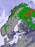 | 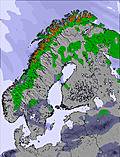 | 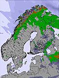 | 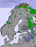 | 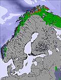 | 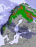 | ||||||||||||
— | — | — | — | — | — | — | — | — | — | — | — | — | — | — | — | — | — | |
mm | — | — | 2 | — | 4 | 3 | 1 | — | 1 | 1 | 2 | 22 | 2 | — | 5 | — | — | — |
max °C | 13 | 17 | 17 | 15 | 18 | 15 | 11 | 15 | 15 | 15 | 17 | 16 | 14 | 18 | 19 | 20 | 20 | 21 |
min °C | 10 | 16 | 11 | 12 | 17 | 12 | 11 | 12 | 12 | 14 | 17 | 13 | 13 | 16 | 18 | 19 | 19 | 15 |
chill °C | 9 | 15 | 9 | 12 | 17 | 11 | 10 | 12 | 11 | 13 | 16 | 13 | 13 | 16 | 18 | 19 | 18 | 14 |
Humid % | 60 | 49 | 92 | 72 | 62 | 94 | 94 | 73 | 94 | 80 | 83 | 99 | 95 | 84 | 86 | 56 | 60 | 87 |
Freeze m | 2350 | 2800 | 3000 | 2850 | 2950 | 2950 | 2950 | 2900 | 3050 | 3500 | 3400 | 3550 | 3750 | 3950 | 3800 | 3800 | 3700 | 3600 |
3:28 | — | — | 3:29 | — | — | 3:29 | — | — | 3:30 | — | — | 3:30 | — | — | 3:31 | — | — | |
— | — | 10:49 | — | — | 10:49 | — | — | 10:49 | — | — | 10:47 | — | — | 10:47 | — | — | 10:46 | |
Go pro and carve into:
Avalanche information: European Avalanche Warning Services (EAWS)
Latest snow reports near Sälen:
| Top snow depth: | 0 cm |
|---|---|
| Bottom snow depth: | 0 cm |
| Fresh snowfall depth: | — |
| Last snowfall: | 14 May 2026 |
| Snow Alerts | Create Alert |
0.0 | Bluebird Powder days Fresh snow, mostly sunny, light wind. |
|---|---|
0.0 | Powder days Fresh snow, limited sun, any wind. |
0.0 | Bluebird days Average snow, mostly sunny, light wind. |
The above table gives the weather forecast for Sälen at the specific elevation of 620 m. Our sophisticated weather models allow us to provide snow forecasts for the top, middle and bottom ski stations of Sälen. To access the weather forecasts for the other elevations, use the tab navigation above the table. For a wider view of the weather, check out the Weather Map of Sweden.
Click here to read further information on freezing levels and how we forecast our temperatures.
Resort name is also written as Salen.
Overall 4.5 Based on 1 vote and 3 reviews
Sälen / Lindvallen is our destination again this year and has been for 7 years in a row. Super destination to teach your kids to ski. We stay in Rødebyen, which is right next to all you need: ski school and ski rental and with ski-in ski-out. Slopes are to the easy side, but great to get your kids started. If you go there outside week 7 and 8, it's not very crowded. Enjoy!
Finn Bøgild from Denmark writes:
Sälen / Lindvallen is our destination again this year and has been for 7 years in a row. Super destination to teach your kids to ski. We stay in Rødebyen, which is right next to all you need: ski school and ski rental and with ski-in ski-out. Slopes are to the easy side, but great to get your kids started. If you go there outside week 7 and 8, it's not very crowded. Enjoy!


 Nearest