


Portillo Re-Opens To Guests Arriving By Helicopter
Chile’s famous Portillo ski resort is reported to have re-opened to guests arriving by helicopter after being cut off by road for more than two weeks by over 6m/20 feet of snowfall.

Next 3 days weather summary:Mostly dry. Warm (max 23°C on Thu morning, min 16°C on Mon night). Wind will be generally light. | Days 4-6 weather summary:Heavy rain (total 24.0mm), heaviest during Sat night. Warm (max 23°C on Thu afternoon, min 16°C on Sat afternoon). Wind will be generally light. | ||||||||||||||||
Mon 3 | Tuesday 4 | Wednesday 5 | Thursday 6 | Friday 7 | Saturday 8 | ||||||||||||
PM | night | AM | PM | night | AM | PM | night | AM | PM | night | AM | PM | night | AM | PM | night | |
cloudy | some clouds | clear | clear | clear | clear | clear | clear | some clouds | some clouds | some clouds | some clouds | some clouds | some clouds | light rain | light rain | heavy rain | |
km/h | |||||||||||||||||
Snow map |  |  |  | 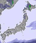 | 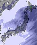 | 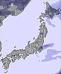 | |||||||||||
— | — | — | — | — | — | — | — | — | — | — | — | — | — | — | — | — | |
mm | — | — | — | — | — | — | — | — | — | — | — | — | — | — | 2 | 5 | 16 |
max °C | 19 | 17 | 19 | 19 | 19 | 21 | 21 | 21 | 23 | 23 | 21 | 23 | 23 | 20 | 17 | 17 | 16 |
min °C | 17 | 16 | 18 | 18 | 18 | 21 | 21 | 20 | 23 | 22 | 21 | 22 | 21 | 18 | 17 | 16 | 16 |
chill °C | 17 | 16 | 18 | 18 | 18 | 21 | 21 | 20 | 23 | 22 | 21 | 22 | 21 | 18 | 17 | 16 | 16 |
Humid % | 57 | 71 | 57 | 72 | 54 | 30 | 56 | 42 | 30 | 54 | 63 | 47 | 66 | 88 | 100 | 99 | 100 |
Freeze m | 4700 | 5000 | 5200 | 5300 | 5350 | 5400 | 5500 | 5400 | 5300 | 5300 | 5150 | 5050 | 5000 | 4950 | 4550 | 4450 | 4350 |
— | — | 4:20 | — | — | 4:22 | — | — | 4:22 | — | — | 4:24 | — | — | 4:24 | — | — | |
6:47 | — | — | 6:46 | — | — | 6:45 | — | — | 6:45 | — | — | 6:43 | — | — | 6:42 | — | |
Go pro and carve into:
Avalanche information: Japan Avalanche Network
Latest snow reports near Tokachi Sahoro Resort:
| Top snow depth: | 0 cm |
|---|---|
| Bottom snow depth: | 0 cm |
| Fresh snowfall depth: | — |
| Last snowfall: | 4 May 2026 |
| Snow Alerts | Create Alert |
0.0 | Bluebird Powder days Fresh snow, mostly sunny, light wind. |
|---|---|
0.0 | Powder days Fresh snow, limited sun, any wind. |
0.0 | Bluebird days Average snow, mostly sunny, light wind. |
The above table gives the weather forecast for Tokachi Sahoro Resort at the specific elevation of 1030 m. Our sophisticated weather models allow us to provide snow forecasts for the top, middle and bottom ski stations of Tokachi Sahoro Resort. To access the weather forecasts for the other elevations, use the tab navigation above the table. For a wider view of the weather, check out the Weather Map of Japan.
Click here to read further information on freezing levels and how we forecast our temperatures.
Resort name is also written as Sahoro Resort.
Overall 3.5 Based on 14 votes and 6 reviews
Disagree with the comments from another reviewer. We've been skiing at Sahoro five times and going again this Christmas. The resort has two hotels including the Club Med. The Club Med is fairly large and self contained with restaurants and bar plus indoor swimming pool and jacuzzi. Lots of families and activities for kids. Ski in/ski out. Ski area itself is not huge but on the other hand the infrastructure was set up for up to eight hotels, not two, so you'll hardly need to queue for lifts even in peak weeks like Christmas. Instructors available in English and Japanese and we've found most are good. Compared to Niseko and Furano, they are better for adults and advanced skiers in my experience and I go there when skiing with friends, but I prefer Sahoro when I take my family.
Stephen from Hong Kong writes:
Disagree with the comments from another reviewer. We've been skiing at Sahoro five times and going again this Christmas. The resort has two hotels including the Club Med. The Club Med is fairly large and self contained with restaurants and bar plus indoor swimming pool and jacuzzi. Lots of families and activities for kids. Ski in/ski out. Ski area itself is not huge but on the other hand the infrastructure was set up for up to eight hotels, not two, so you'll hardly need to queue for lifts even in peak weeks like Christmas. Instructors available in English and Japanese and we've found most are good. Compared to Niseko and Furano, they are better for adults and advanced skiers in my experience and I go there when skiing with friends, but I prefer Sahoro when I take my family.
Read 5 more reviews of Tokachi Sahoro Resort or submit your own


 Nearest