

Banff Sunshine Village Opening for Summer Skiing
Banff Sunshine Village has confirmed it will reopen for a fortnight of summer skiing, from this weekend. The only ski area in Canada to be open into July.

Next 3 days weather summary:Light rain (total 5.0mm), mostly falling on Tue afternoon. Warm (max 23°C on Thu morning, min 10°C on Tue night). Wind will be generally light. | Days 4-6 weather summary:Heavy rain (total 33.0mm), heaviest during Fri afternoon. Very mild (max 18°C on Fri morning, min 8°C on Sun night). Wind will be generally light. | |||||||||||||||||
Tuesday 23 | Wednesday 24 | Thursday 25 | Friday 26 | Saturday 27 | Sunday 28 | |||||||||||||
AM | PM | night | AM | PM | night | AM | PM | night | AM | PM | night | AM | PM | night | AM | PM | night | |
light rain | light rain | cloudy | some clouds | clear | clear | clear | cloudy | cloudy | light rain | heavy rain | light rain | light rain | some clouds | rain shwrs | rain shwrs | rain shwrs | clear | |
km/h | ||||||||||||||||||
Snow map | 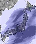 | 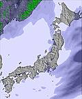 |  |  |  |  | ||||||||||||
— | — | — | — | — | — | — | — | — | — | — | — | — | — | — | — | — | — | |
mm | 2 | 3 | — | — | — | — | — | — | — | 4 | 17 | 4 | 2 | — | 2 | 2 | 2 | — |
max °C | 14 | 15 | 12 | 20 | 19 | 14 | 23 | 22 | 17 | 18 | 16 | 16 | 14 | 17 | 13 | 15 | 15 | 11 |
min °C | 13 | 13 | 10 | 17 | 17 | 10 | 20 | 19 | 15 | 17 | 16 | 13 | 13 | 15 | 12 | 13 | 12 | 8 |
chill °C | 13 | 13 | 10 | 17 | 17 | 10 | 20 | 19 | 15 | 16 | 16 | 12 | 12 | 15 | 11 | 12 | 11 | 7 |
Humid % | 97 | 83 | 89 | 58 | 62 | 86 | 54 | 51 | 90 | 93 | 99 | 96 | 98 | 90 | 94 | 91 | 78 | 91 |
Freeze m | 2550 | 2600 | 2650 | 2800 | 2900 | 3350 | 3650 | 3700 | 3800 | 4000 | 3950 | 3250 | 3200 | 3300 | 3800 | 3950 | 3800 | 3700 |
3:58 | — | — | 3:59 | — | — | 3:59 | — | — | 3:59 | — | — | 4:00 | — | — | 4:00 | — | — | |
— | 7:19 | — | — | 7:19 | — | — | 7:19 | — | — | 7:19 | — | — | 7:19 | — | — | 7:19 | — | |
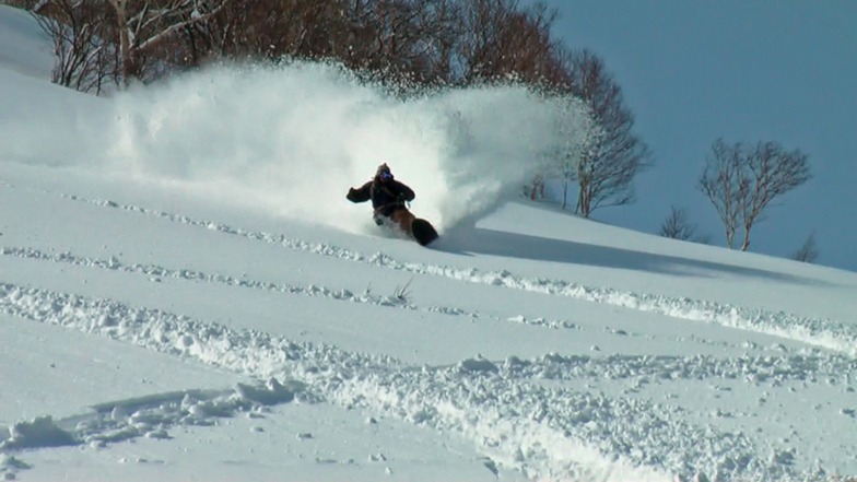
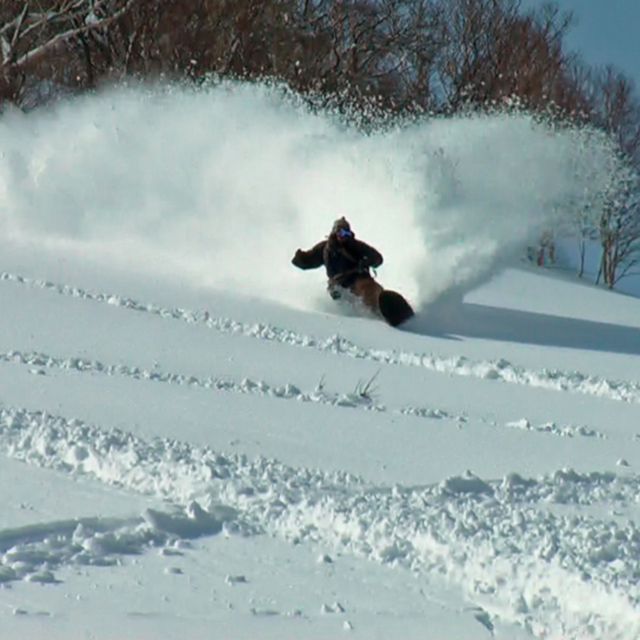
Go pro and carve into:
Avalanche information: Japan Avalanche Network
Latest snow reports near Niseko Grand Hirafu:
| Top snow depth: | 0 cm |
|---|---|
| Bottom snow depth: | 0 cm |
| Fresh snowfall depth: | — |
| Last snowfall: | 4 May 2026 |
| Snow Alerts | Create Alert |
0.0 | Bluebird Powder days Fresh snow, mostly sunny, light wind. |
|---|---|
0.0 | Powder days Fresh snow, limited sun, any wind. |
0.0 | Bluebird days Average snow, mostly sunny, light wind. |
The above table gives the weather forecast for Niseko Grand Hirafu at the specific elevation of 256 m. Our sophisticated weather models allow us to provide snow forecasts for the top, middle and bottom ski stations of Niseko Grand Hirafu. To access the weather forecasts for the other elevations, use the tab navigation above the table. For a wider view of the weather, check out the Weather Map of Japan.
Click here to read further information on freezing levels and how we forecast our temperatures.
Resort name is also written as Niseko Hirafu.
Overall 3.9 Based on 81 votes and 120 reviews
My fifth visit to Niseko over the last 17 years. Its changed a lot but not for the better. There is now practically no Japanese experience to be had here. Its overcrowded with all infrastructure lifts/resort restaurants/mountain restaurants/buses/trains packed to the max (the only time I didn't stand on public transport in 2 weeks was on the train from Sapporo to the airport). You will probably get some great snow during your visit but be prepared to queue for it in all aspects of your holiday lifts/eating/getting around and theres a good chance most of the good stuff will be tracked out by lunch (or earlier). It may be me but it seems that they have made it harder to get to other resorts close by, Rusutsu/Moiwa used to be easy public/free transport now it's taxi and a bus or 2 buses. A car is becoming more essential in Niseko just from making getting around less painful. Although it will be chaos if that eventuates, pretty sure parking is not on anyone's list! The old Niseko is gone and the current one is losing its appeal (other than the snow of course)!
Cam from Australia writes:
My fifth visit to Niseko over the last 17 years. Its changed a lot but not for the better. There is now practically no Japanese experience to be had here. Its overcrowded with all infrastructure lifts/resort restaurants/mountain restaurants/buses/trains packed to the max (the only time I didn't stand on public transport in 2 weeks was on the train from Sapporo to the airport). You will probably get some great snow during your visit but be prepared to queue for it in all aspects of your holiday lifts/eating/getting around and theres a good chance most of the good stuff will be tracked out by lunch (or earlier). It may be me but it seems that they have made it harder to get to other resorts close by, Rusutsu/Moiwa used to be easy public/free transport now it's taxi and a bus or 2 buses. A car is becoming more essential in Niseko just from making getting around less painful. Although it will be chaos if that eventuates, pretty sure parking is not on anyone's list! The old Niseko is gone and the current one is losing its appeal (other than the snow of course)!
Read 119 more reviews of Niseko Grand Hirafu or submit your own


 Nearest