
Global Weekly Snow Roundup #319
Weekly Snow News for the world, updated 18 June 2026: Argentina and Lesotho's seasons begin, Tignes and Sunshine to reopen this weekend as Riksgransen ends its 2026 season.

Next 3 days weather summary:Moderate rain (total 19.0mm), heaviest on Sat morning. Very mild (max 12°C on Fri night, min 5°C on Fri morning). Wind will be generally light. | Days 4-6 weather summary:Heavy rain (total 61.0mm), heaviest during Mon night. Mild temperatures (max 8°C on Tue night, min 3°C on Tue morning). Winds decreasing (fresh winds from the WSW on Sun night, calm by Tue afternoon). | ||||||||||||||||
Thu 18 | Friday 19 | Saturday 20 | Sunday 21 | Monday 22 | Tuesday 23 | ||||||||||||
PM | night | AM | PM | night | AM | PM | night | AM | PM | night | AM | PM | night | AM | PM | night | |
some clouds | cloudy | light rain | some clouds | rain shwrs | mod. rain | light rain | light rain | light rain | light rain | mod. rain | mod. rain | heavy rain | heavy rain | light rain | some clouds | some clouds | |
km/h | |||||||||||||||||
Snow map | 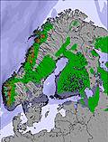 | 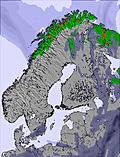 | 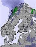 | 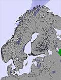 | 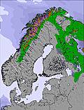 | 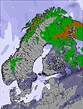 | |||||||||||
— | — | — | — | — | — | — | — | — | — | — | — | — | — | — | — | — | |
mm | — | — | 1 | — | 1 | 6 | 4 | 3 | 4 | 3 | 7 | 6 | 13 | 26 | 5 | — | — |
max °C | 10 | 8 | 6 | 9 | 12 | 12 | 10 | 8 | 7 | 7 | 5 | 4 | 4 | 5 | 3 | 5 | 8 |
min °C | 9 | 6 | 5 | 9 | 10 | 11 | 8 | 7 | 7 | 6 | 4 | 4 | 4 | 4 | 3 | 4 | 6 |
chill °C | 9 | 5 | 4 | 9 | 10 | 9 | 6 | 5 | 4 | 2 | -1 | -1 | -1 | 0 | 0 | 4 | 5 |
Humid % | 54 | 63 | 85 | 73 | 59 | 92 | 97 | 85 | 92 | 95 | 89 | 95 | 98 | 98 | 95 | 77 | 70 |
Freeze m | 1950 | 1800 | 1600 | 1900 | 2450 | 2800 | 2450 | 1950 | 1550 | 1450 | 1100 | 1100 | 1250 | 1350 | 1000 | 1300 | 1700 |
— | — | 12:00 | — | — | 12:00 | — | — | 12:00 | — | — | 12:00 | — | — | 12:00 | — | — | |
12:00 | — | 12:00 | — | — | 12:00 | — | — | 12:00 | — | — | 12:00 | — | — | 12:00 | — | — | |
Go pro and carve into:
Avalanche information: Varsom.no Avalanche Warnings
Latest snow reports near Narvik:
| Top snow depth: | 0 cm |
|---|---|
| Bottom snow depth: | 0 cm |
| Fresh snowfall depth: | — |
| Last snowfall: | 29 May 2026 |
| Snow Alerts | Create Alert |
0.0 | Bluebird Powder days Fresh snow, mostly sunny, light wind. |
|---|---|
0.0 | Powder days Fresh snow, limited sun, any wind. |
0.0 | Bluebird days Average snow, mostly sunny, light wind. |
The above table gives the weather forecast for Narvik at the specific elevation of 564 m. Our sophisticated weather models allow us to provide snow forecasts for the top, middle and bottom ski stations of Narvik. To access the weather forecasts for the other elevations, use the tab navigation above the table. For a wider view of the weather, check out the Weather Map of Norway.
Click here to read further information on freezing levels and how we forecast our temperatures.
Overall 2.9 Based on 12 votes and 1 review
Great off-piste and tree runs, plus hiking to powder for the advanced people. Those looking for lots of long runs may be a little disappointed. Probably ok for beginners. Park is nice but not huge - a few funboxes and rails plus a kicker and table top. Tons of natural features everywhere though. No pipe. Advise you to bring a head torch as it gets dark early and is floodlit but not in all areas. There are many tree runs in powder in semi-dark conditions! Also, everyone should ideally have a pair of clear goggle lenses due to low light conditions - and in the week (Jan/Feb 2013) lifts open in the evening. Daytime at weekend. When deciding to travel, check the official website for opening dates of the gondola to the top, as otherwise there is only one T bar from the bottom!
Will Mowlam from Norway writes:
Great off-piste and tree runs, plus hiking to powder for the advanced people. Those looking for lots of long runs may be a little disappointed. Probably ok for beginners. Park is nice but not huge - a few funboxes and rails plus a kicker and table top. Tons of natural features everywhere though. No pipe.
Advise you to bring a head torch as it gets dark early and is floodlit but not in all areas. There are many tree runs in powder in semi-dark conditions!
Also, everyone should ideally have a pair of clear goggle lenses due to low light conditions - and in the week (Jan/Feb 2013) lifts open in the evening. Daytime at weekend.
When deciding to travel, check the official website for opening dates of the gondola to the top, as otherwise there is only one T bar from the bottom!


 Nearest